
Teton County, Wyoming facts for kids
Quick facts for kids
Teton County
|
||
|---|---|---|

|
||
|
||

Location within the U.S. state of Wyoming
|
||
 Wyoming's location within the U.S. |
||
| Country | ||
| State | ||
| Founded | February 15, 1921 (authorized) 1922 (organized) |
|
| Named for | Teton Range | |
| Seat | Jackson | |
| Largest town | Jackson | |
| Area | ||
| • Total | 4,216 sq mi (10,920 km2) | |
| • Land | 3,995 sq mi (10,350 km2) | |
| • Water | 221 sq mi (570 km2) 5.2%% | |
| Population
(2020)
|
||
| • Total | 23,331 | |
| • Estimate
(2019)
|
23,464 | |
| • Density | 5.5339/sq mi (2.13666/km2) | |
| Time zone | UTC−7 (Mountain) | |
| • Summer (DST) | UTC−6 (MDT) | |
| Congressional district | At-large | |

Teton County is a county in the U.S. state of Wyoming. As of the 2020 United States Census, the population was 23,331. Its county seat is Jackson. Its west boundary line is also the Wyoming state boundary shared with Idaho and the southern tip of Montana. Teton County is part of the Jackson, WY-ID Micropolitan Statistical Area. Teton County contains the Jackson Hole ski area, all of Grand Teton National Park, and 40.4% of Yellowstone National Park's total area, including over 96.6% of its water area (largely in Yellowstone Lake).
Contents
History
Teton County was created February 15, 1921 with land from Lincoln County and organized the following year. The county was named for the Teton Range. The county was created because the inhabitants lived too far away from Kemmerer, the county seat of Lincoln County. The creation of the county required a special act of the Wyoming Legislature, because the area was too poor and had too few people to qualify for county status under the normal requirements.
Geography

According to the U.S. Census Bureau, the county has a total area of 4,216 square miles (10,920 km2), of which 3,995 square miles (10,350 km2) is land and 221 square miles (570 km2) (5.2%) is water.
Adjacent counties
- Park County (northeast)
- Fremont County (east)
- Sublette County (southeast)
- Lincoln County (south)
- Bonneville County, Idaho (southwest)
- Teton County, Idaho (southwest)
- Fremont County, Idaho (west)
- Gallatin County, Montana (northwest)
Teton County, Wyoming and Teton County, Idaho, are two of twenty-two counties or parishes in the United States with the same name to border each other across state lines. The others are Big Horn County, Montana and Big Horn County, Wyoming; Bristol County, Massachusetts and Bristol County, Rhode Island; Escambia County, Alabama and Escambia County, Florida; Kent County, Delaware and Kent County, Maryland; Park County, Montana and Park County, Wyoming; Pike County, Illinois and Pike County, Missouri; Sabine County, Texas and Sabine Parish, Louisiana; San Juan County, New Mexico and San Juan County, Utah; Union Parish, Louisiana and Union County, Arkansas; and Vermilion County, Illinois and Vermillion County, Indiana (both these counties are named for the Vermilion River, despite their different spellings).
National protected areas
- Bridger-Teton National Forest (part)
- Caribou-Targhee National Forest (part)
- Grand Teton National Park
- John D. Rockefeller Memorial Parkway
- National Elk Refuge
- Shoshone National Forest (part)
- Yellowstone National Park (part)
Demographics
| Historical population | |||
|---|---|---|---|
| Census | Pop. | %± | |
| 1930 | 2,003 | — | |
| 1940 | 2,543 | 27.0% | |
| 1950 | 2,593 | 2.0% | |
| 1960 | 3,062 | 18.1% | |
| 1970 | 4,823 | 57.5% | |
| 1980 | 9,355 | 94.0% | |
| 1990 | 11,172 | 19.4% | |
| 2000 | 18,251 | 63.4% | |
| 2010 | 21,294 | 16.7% | |
| 2020 | 23,331 | 9.6% | |
| US Decennial Census 1870–2000 2010–2016 |
|||
2010 census
As of the 2010 United States Census, there were 21,294 people, 8,973 households, and 4,938 families in the county. The population density was 5.3 inhabitants per square mile (2.0/km2). There were 12,813 housing units at an average density of 3.2 per square mile (1.2/km2). The racial makeup of the county was 88.4% white, 1.1% Asian, 0.5% American Indian, 0.2% black or African American, 0.1% Pacific islander, 8.1% from other races, and 1.6% from two or more races. Those of Hispanic or Latino origin made up 15.0% of the population. In terms of ancestry, 22.2% were German, 14.9% were English, 13.0% were Irish, and 11.1% were American.
Of the 8,973 households, 25.5% had children under the age of 18 living with them, 45.7% were married couples living together, 5.6% had a female householder with no husband present, 45.0% were non-families, and 29.2% of all households were made up of individuals. The average household size was 2.34 and the average family size was 2.89. The median age was 36.9 years.
The median income for a household in the county was $70,271 and the median income for a family was $90,596. Males had a median income of $40,594 versus $36,715 for females. The per capita income for the county was $42,224. About 5.1% of families and 8.2% of the population were below the poverty line, including 15.5% of those under age 18 and 0.8% of those age 65 or over.
Economy
A 2019 Bloomberg L.P. report (citing Bureau of Economic Analysis figures) found that Teton had the highest average incomes per capita of any county in the United States, at $252,000. This was partly attributed to the high incomes of Jackson Hole residents, where property owners include Bill Gates.
As of the fourth quarter of 2021, the median home price in Teton County was $1,060,093, an increase of 17.8% from the prior year.
Communities

Town
- Jackson (county seat)
Census-designated places
- Alta
- Hoback
- Kelly
- Moose Wilson Road
- Rafter J Ranch
- South Park
- Teton Village
- Wilson
Unincorporated communities
- Colter Bay
- Moran
- Moose
- West Thumb
Images for kids
-
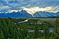
Snake River Overlook and the Teton Range, Teton County

See also
 In Spanish: Condado de Teton (Wyoming) para niños
