
Tikipunga facts for kids
Quick facts for kids
Tikipunga
|
|
|---|---|
|
Suburb
|
|

|
|

Tikipunga
Location in New Zealand
|
|
| Country | New Zealand |
| Local authority | Whangarei District Council |
| Electoral ward | Denby Ward |
| Area | |
| • Land | 868 ha (2,145 acre) |
| Population
(June 2022)
|
|
| • Total | 7,840 |
| Kauri | Glenbervie | |
| Kamo |
|
|
| Whau Valley | Otangarei |
Tikipunga is one of the biggest suburbs in Whangārei, New Zealand. It is in the north-east part of the town and has the landmark Whangārei Falls nearby.
Contents
Whangarei Falls
At Whangarei Falls, the Hātea River drops 26 metres (85 ft) over a basalt lava flow. There are walkways around the falls and along the river. The falls were originally known as Otuihau, and have been a picnic spot since at least the 1890s. In the 1920s, the land was bought by Archibald Clapham (of Clapham's Clocks) to prevent commercial exploitation of the falls. The Whangarei Businessmen's Association raised funds in 1946 to buy the land on behalf of the citizens of the town.
Amenities
The Paramount Plaza shopping centre on Paramount Parade serves the suburb and is anchored by a large Countdown Supermarket. It contains a service station, several food outlets, a liquor store, a pharmacy, a video store and a medical centre. Nearby the plaza is the Tikipunga branch of the Whangarei Libraries. There is also a smaller suburban shopping strip on the corner of Kiripaka and Spedding roads.
35°41′06″S 174°19′43″E / 35.684873°S 174.328543°E
Demographics
Tikipunga covers 5.48 km2 (2.12 sq mi) and had an estimated population of 7840 as of June 2022, with a population density of 1431 people per km2.
| Historical population | ||
|---|---|---|
| Year | Pop. | ±% p.a. |
| 2006 | 5,763 | — |
| 2013 | 5,484 | −0.71% |
| 2018 | 6,906 | +4.72% |
Tikipunga had a population of 6,906 at the 2018 New Zealand census, an increase of 1,422 people (25.9%) since the 2013 census, and an increase of 1,143 people (19.8%) since the 2006 census. There were 2,433 households, comprising 3,213 males and 3,693 females, giving a sex ratio of 0.87 males per female, with 1,662 people (24.1%) aged under 15 years, 1,296 (18.8%) aged 15 to 29, 2,496 (36.1%) aged 30 to 64, and 1,452 (21.0%) aged 65 or older.
Ethnicities were 69.8% European/Pākehā, 41.8% Māori, 6.3% Pacific peoples, 3.3% Asian, and 1.6% other ethnicities. People may identify with more than one ethnicity.
The percentage of people born overseas was 12.9, compared with 27.1% nationally.
Although some people chose not to answer the census's question about religious affiliation, 48.4% had no religion, 36.9% were Christian, 4.2% had Māori religious beliefs, 0.4% were Hindu, 0.1% were Muslim, 0.6% were Buddhist and 1.2% had other religions.
Of those at least 15 years old, 522 (10.0%) people had a bachelor's or higher degree, and 1,416 (27.0%) people had no formal qualifications. 408 people (7.8%) earned over $70,000 compared to 17.2% nationally. The employment status of those at least 15 was that 2,118 (40.4%) people were employed full-time, 606 (11.6%) were part-time, and 315 (6.0%) were unemployed.
| Name | Area (km2) | Population | Density (per km2) | Households | Median age | Median income |
|---|---|---|---|---|---|---|
| Tikipunga North | 2.74 | 3,003 | 1,096 | 1,059 | 36.4 years | $21,900 |
| Tikipunga South | 2.74 | 3,903 | 1,424 | 1,374 | 35.4 years | $25,500 |
| New Zealand | 37.4 years | $31,800 |
Education
Tikipunga High School is a state coeducational Year 7-13 secondary school on Corks Road, with a roll of 345 students as of April 2023. The school opened in 1971.
Tikipunga Primary School is a contributing primary (years 1–6) school with a roll of 285 students as of April 2023.
Te Kura Kaupapa Maori o Te Rawhiti Roa is a composite (years 1–15) school with a roll of 182 students as of April 2023.
All these schools are coeducational.
-
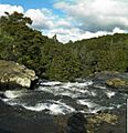
Whangarei Falls as seen from a walkway over the river.
-
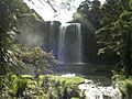
Falls from below.
.jpg)

