
Tishomingo County, Mississippi facts for kids
Quick facts for kids
Tishomingo County
|
|
|---|---|
| County of Tishomingo | |

Tishomingo County Courthouse
|
|

Location within the U.S. state of Mississippi
|
|
 Mississippi's location within the U.S. |
|
| Country | |
| State | |
| Founded | February 9, 1836 |
| Named for | Tishomingo |
| Seat | Iuka |
| Largest city | Iuka |
| Area | |
| • Total | 445 sq mi (1,150 km2) |
| • Land | 424 sq mi (1,100 km2) |
| • Water | 20 sq mi (50 km2) 4.6% |
| Population
(2010)
|
|
| • Total | 19,593 |
| • Estimate
(2018)
|
19,454 |
| • Density | 44.03/sq mi (17.000/km2) |
| Time zone | UTC−6 (Central) |
| • Summer (DST) | UTC−5 (CDT) |
| Congressional district | 1st |
Tishomingo County is a county located in the northeastern corner of the U.S. state of Mississippi. As of the 2010 census, the population was 19,593. Its county seat is Iuka.
Contents
History
Tishomingo County was organized February 9, 1836, from Chickasaw lands that were ceded to the United States. The Chickasaw were forced by Indian Removal to relocate to lands in the Indian Territory (now Oklahoma). In 1870 this land was divided into Alcorn, Prentiss and Tishomingo counties.

Tishomingo was referred to in the Coen brothers' film, O Brother, Where Art Thou?.
Geography

According to the U.S. Census Bureau, the county has a total area of 445 square miles (1,150 km2), of which 424 square miles (1,100 km2) is land and 20 square miles (52 km2) (4.6%) is water. The highest natural point in Mississippi, the 806 feet (246 meter) Woodall Mountain, is located in the county. Tishomingo County is the only county in Mississippi with outcroppings of natural limestone formations.
Adjacent counties
- Hardin County, Tennessee (north)
- Lauderdale County, Alabama (northeast)
- Colbert County, Alabama (east)
- Franklin County, Alabama (southeast)
- Itawamba County (south)
- Prentiss County (southwest)
- Alcorn County (northwest)
Major highways
- U.S. Route 72
- Mississippi Highway 4
- Mississippi Highway 25
- Mississippi Highway 30
- Mississippi Highway 172
- Mississippi Highway 350
- Mississippi Highway 364
- Mississippi Highway 365
- Mississippi Highway 366
- Mississippi Highway 760
- Natchez Trace Parkway
National protected area
![]() Natchez Trace Parkway
Natchez Trace Parkway
Demographics
| Historical population | |||
|---|---|---|---|
| Census | Pop. | %± | |
| 1840 | 6,681 | — | |
| 1850 | 15,490 | 131.9% | |
| 1860 | 24,149 | 55.9% | |
| 1870 | 7,350 | −69.6% | |
| 1880 | 8,774 | 19.4% | |
| 1890 | 9,302 | 6.0% | |
| 1900 | 10,124 | 8.8% | |
| 1910 | 13,067 | 29.1% | |
| 1920 | 15,091 | 15.5% | |
| 1930 | 16,411 | 8.7% | |
| 1940 | 16,974 | 3.4% | |
| 1950 | 15,544 | −8.4% | |
| 1960 | 13,889 | −10.6% | |
| 1970 | 14,940 | 7.6% | |
| 1980 | 18,434 | 23.4% | |
| 1990 | 17,683 | −4.1% | |
| 2000 | 19,163 | 8.4% | |
| 2010 | 19,593 | 2.2% | |
| 2018 (est.) | 19,454 | −0.7% | |
| U.S. Decennial Census 1790-1960 1900-1990 1990-2000 2010-2013 |
|||
2020 census
| Race | Num. | Perc. |
|---|---|---|
| White (non-Hispanic) | 17,169 | 91.08% |
| Black or African American (non-Hispanic) | 433 | 2.3% |
| Native American | 48 | 0.25% |
| Asian | 41 | 0.22% |
| Other/Mixed | 622 | 3.3% |
| Hispanic or Latino | 537 | 2.85% |
As of the 2020 United States census, there were 18,850 people, 7,635 households, and 5,035 families residing in the county.
2010 census
As of the 2010 United States Census, there were 19,593 people living in the county. 94.5% were White, 2.6% Black or African American, 0.2% Native American, 0.1% Asian, 1.7% of some other race and 0.8% of two or more races. 2.8% were Hispanic or Latino (of any race).
Recreation

- Tishomingo State Park is located in the foothills of the Appalachian Mountains in Tishomingo County, Mississippi, north of Tupelo, Mississippi. Activities in the park including canoeing, rock climbing, fishing and hiking. The park was constructed by the Civilian Conservation Corps during the 1930s. Many of the original buildings are still standing. The park is named for an early leader of the Chickasaw nation, Chief Tishomingo (1734-1838).
- J.P. Coleman State Park is a state park in the U.S. state of Mississippi. It is located north of Iuka off Mississippi Highway 25. It sits along the banks of the Tennessee River and Pickwick Lake. The park is named for James P. Coleman, a former governor of Mississippi. Activities include sailing, swimming, camping, hiking, skiing, and fishing for smallmouth bass.
- Bay Springs Lake is a reservoir on the Tennessee-Tombigbee Waterway in the U.S. state of Mississippi. It is impounded by the Jamie Whitten Lock and Dam. The lake is approximately nine miles long, between waterway mile markers 412 at the dam, and 421 near the entrance to the divide cut.
- The Tennessee–Tombigbee Waterway (popularly known as the Tenn-Tom) is a 234-mile (377 km) artificial waterway that provides a connecting link between the Tennessee and Tombigbee rivers. The waterway begins at Pickwick Lake on the Tennessee River, then flows southward through northeast Mississippi and west Alabama, finally connecting with the established Warrior-Tombigbee navigation system at Demopolis, Alabama.
Communities
City
- Iuka (county seat)
Towns
Villages
Unincorporated communities
Gallery
-
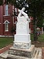
Monument to Confederate soldiers who served in the American Civil War
-
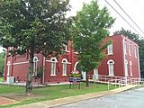
Southwest view of the Old Tishomingo County courthouse in Iuka, Mississippi.
-
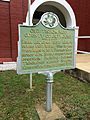
State historical marker for Old Tishomingo County Courthouse


See also
 In Spanish: Condado de Tishomingo para niños
