
Tocumwal facts for kids
Quick facts for kids TocumwalNew South Wales |
|||||||||
|---|---|---|---|---|---|---|---|---|---|

The levee and foreshore park at Tocumwal
|
|||||||||

Tocumwal
Location in New South Wales
|
|||||||||
| Population | 2,682 (2016 census) | ||||||||
| • Density | 5,000/km2 (13,000/sq mi) | ||||||||
| Postcode(s) | 2714 | ||||||||
| Elevation | 126 m (413 ft) | ||||||||
| Location | 270 km (168 mi) from Melbourne | ||||||||
| LGA(s) | Berrigan Shire | ||||||||
| County | Denison | ||||||||
| State electorate(s) | Murray | ||||||||
| Federal Division(s) | Farrer | ||||||||
|
|||||||||
Tocumwal ( TOH-kəm-wawl) is a town in the southern Riverina region of New South Wales, Australia, in the Berrigan Shire local government area, near the Victorian border. The town is situated on the banks of the Murray River, 270 kilometres (170 mi) north of the city of Melbourne. The Newell Highway and Murray Valley Highway join at the Murray River, and form part of the main road route National Highway A39 between Brisbane and Melbourne. At the 2016 census, Tocumwal had a population of 2,682. The winner of several 'Tidy Town' awards, Tocumwal is affectionately known as 'The Jewel in the Crown That Is The Riverina District'.
The town is said to be named for the local Aboriginal word for "deep hole in the river".
Contents
History
Prior to European settlement, the Tocumwal area was inhabited by the Ulupna and Bangerang Aborigines. The first pastoral runs were established in the 1840s. The town was established in the early 1860s and recognised as a village in 1872. Tocumwal Post Office opened on 1 August 1868.
Prior to Federation, Tocumwal was an important customs point for goods crossing between the then colonies of Victoria and New South Wales.
A standard gauge branch line from the New South Wales Government Railways Main Southern railway line at Junee reached Narrandera in 1881 and a branch from Narrandera was completed to Tocumwal in 1898. The broad gauge Victorian Railways Melbourne-Shepparton railway line was extended to Tocumwal in 1908, creating a break-of-gauge at Tocumwal until the New South Wales Government Railways line was closed south of Narrandera (about 1980).
During World War 2 the town was the site of Royal Australian Air Force Station Tocumwal, which was a major Royal Australian Air Force training airfield and aircraft depot. Units included (at various times) the 5 Operational Training Unit, 7 Operational Training Unit, 7 Aircraft Depot and the Paratroop Training Unit. Today, the airfield is a renowned gliding site.
After the war families were housed at the American Air Force Hospital,the men travelled daily over the river to Yarroweyah to work on farms which they could then apply for under the soldier settlement scheme. The Hospital was on or next to Barooga Station. Living quarters were made in long Nissen huts, 3-4 in each with a shared bathroom. Single quarters were at the front and a cook was employed for them.
After the war ended, many of the Air Force houses in Tocumwal were disassembled and trucked to Canberra to be rebuilt and reused in new and inner city suburbs where they provided Government housing to workers coming from Melbourne and Sydney to construct the new Capital City. To this day they remain a distinctive architectural form in suburbs such as Ainslie.
Because of the break-of-gauge between the railways north and south of Tocumwal, this station was a natural choice for military oriented storage facilities and munitions dumps.
Also during World War 2, Tocumwal was the location of RAAF No.14 Inland Aircraft Fuel Depot (IAFD), completed in 1942 and closed on 14 June 1944. Usually consisting of 4 tanks, 31 fuel depots were built across Australia for the storage and supply of aircraft fuel for the RAAF and the US Army Air Forces at a total cost of £900,000 ($1,800,000).
Climate
Tocumwal has a semi-arid climate (BSk).
| Climate data for Tocumwal | |||||||||||||
|---|---|---|---|---|---|---|---|---|---|---|---|---|---|
| Month | Jan | Feb | Mar | Apr | May | Jun | Jul | Aug | Sep | Oct | Nov | Dec | Year |
| Record high °C (°F) | 45.8 (114.4) |
45.7 (114.3) |
41.8 (107.2) |
37.0 (98.6) |
29.0 (84.2) |
23.7 (74.7) |
25.5 (77.9) |
30.5 (86.9) |
34.0 (93.2) |
37.0 (98.6) |
43.5 (110.3) |
43.5 (110.3) |
45.8 (114.4) |
| Average high °C (°F) | 31.8 (89.2) |
31.4 (88.5) |
28.0 (82.4) |
23.0 (73.4) |
18.4 (65.1) |
14.8 (58.6) |
13.9 (57.0) |
15.8 (60.4) |
18.8 (65.8) |
22.4 (72.3) |
26.7 (80.1) |
29.4 (84.9) |
22.9 (73.2) |
| Average low °C (°F) | 16.0 (60.8) |
16.1 (61.0) |
13.6 (56.5) |
9.7 (49.5) |
6.7 (44.1) |
4.3 (39.7) |
3.4 (38.1) |
4.3 (39.7) |
6.3 (43.3) |
8.8 (47.8) |
11.9 (53.4) |
14.0 (57.2) |
9.6 (49.3) |
| Record low °C (°F) | 7.4 (45.3) |
6.8 (44.2) |
5.0 (41.0) |
0.0 (32.0) |
−2.1 (28.2) |
−4.8 (23.4) |
−4.3 (24.3) |
−4.0 (24.8) |
−1.5 (29.3) |
1.3 (34.3) |
2.9 (37.2) |
5.1 (41.2) |
−4.8 (23.4) |
| Average precipitation mm (inches) | 32.4 (1.28) |
29.8 (1.17) |
34.8 (1.37) |
31.7 (1.25) |
40.9 (1.61) |
43.9 (1.73) |
42.3 (1.67) |
43.0 (1.69) |
38.9 (1.53) |
43.4 (1.71) |
34.2 (1.35) |
34.0 (1.34) |
449.5 (17.70) |
| Average precipitation days | 3.9 | 3.5 | 4.5 | 5.0 | 7.2 | 9.0 | 10.1 | 10.1 | 8.2 | 7.2 | 5.5 | 4.5 | 78.7 |
| Average relative humidity (%) | 33 | 35 | 38 | 46 | 57 | 65 | 65 | 57 | 52 | 45 | 38 | 33 | 47 |
Facilities
Tocumwal has one state and one Catholic primary school. The nearest high school is in Finley, 21 kilometres (13 mi) to the north.
Australian rules football, cricket and netball are all very popular in the town. Notable sporting teams include the Tocumwal Football Club (The Bloods) who compete in the Picola & District Football League
Tocumwal is in the federal Division of Farrer and the state Electoral district of Murray.
Tocumwal was also where the largest Murray cod in the world was caught.
Tocumwal has a 36-hole championship golf course at the Tocumwal Golf Club, a bowls club and is well known internationally for gliding at SportAviation.
Gallery
-
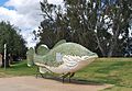
The Big Murray Cod on the Tocumwal foreshore
-
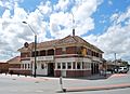
The Tattersalls Hotel, one of four pubs in Tocumwal
-
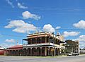
The Terminus Hotel, another of the four pubs
-
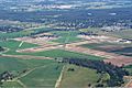
Tocumwal Airport


Images for kids
-
The Big Murray Cod on the Tocumwal foreshore
-
The Tattersalls Hotel, one of four pubs in Tocumwal
-
The Terminus Hotel, another of the four pubs
-
Tocumwal Airport
