
Tracy, California facts for kids
Quick facts for kids
Tracy, California
|
|
|---|---|
.JPG)   .jpg) |
|
| Motto(s):
Think Inside the Triangle
|
|

Location in San Joaquin County and the state of California
|
|

Tracy, California
Location in the United States
|
|
| Country | United States |
| State | California |
| County | San Joaquin |
| Incorporated | July 22, 1910 |
| Government | |
| • Type | City Manager |
| Area | |
| • Total | 26.03 sq mi (67.42 km2) |
| • Land | 25.90 sq mi (67.07 km2) |
| • Water | 0.14 sq mi (0.35 km2) 0.61% |
| Elevation | 52 ft (16 m) |
| Population
(2020)
|
|
| • Total | 93,000 |
| • Rank | 84th in California |
| • Density | 3,573/sq mi (1,379/km2) |
| Time zone | UTC−8 (Pacific) |
| • Summer (DST) | UTC−7 (PDT) |
| ZIP codes |
95304, 95376–95378, 95385, 95391
|
| Area code | 209 |
| FIPS code | 06-80238 |
| GNIS feature IDs | 277621, 2412090 |
Tracy is the second most populated city in San Joaquin County, California, United States. The population was 93,000 at the 2020 census. Tracy is located inside a geographic triangle formed by Interstate 205 on the north side of the city, Interstate 5 to the east, and Interstate 580 to the southwest.
Contents
History
The origins of Tracy are related to the mid-19th century construction of Central Pacific Railroad lines running from Sacramento through Stockton and to the San Francisco Bay Area. Tracy is part of the San Jose-San Francisco-Oakland, CA Combined Statistical Area, an extension of the Bay Area. A number of small communities sprang up along these lines, including the one named for railroad director Lathrop J. Tracy. Incorporated in 1910, Tracy grew rapidly and prospered as an agricultural area even when railroad operations began to decline in the 1950s. Beginning in the 1980s, Tracy experienced a growth spurt as people migrated to the city looking for affordable alternatives to Bay Area home prices, in addition to a more tranquil lifestyle. A steady period of growth ensued, as many companies found Tracy an ideal location for their distribution facilities.
Geography and environment
Located in the Greater Bay Area, Tracy sits near both fertile and (due to a region of hills west of Tracy) infertile agricultural lands. Tracy has a Mediterranean climate. Some of this land (in the east and mostly north of Tracy because of the moist Delta river system) has come under increasing development pressure as the San Francisco Bay Area's vigorous population growth has spilled over into the Tracy area as well as other locations such as the new town of Mountain House (because of TRACY's Measure A in 1990) near the Bay Area's edge.
In an effort to reduce its impact on the environment, the city launched the Emerald Tracy Project in September 2009. City spokesman Matt Robinson said that if it succeeds, Tracy will be the second city after Riverside to satisfy the state’s goal for sustainable communities.
Tracy is marked by a semi-arid climate (Köppen BSh), with mild, moist winters and very hot and dry summers, thus displaying Mediterranean characteristics. December and January are the coolest months, and average around 47.1 °F (8.4 °C), and there are 19 nights with lows at or below freezing annually, with the coldest night of the year typically bottoming out below 30 °F (−1.1 °C). July is the warmest month, averaging 76.4 °F (28.3 °C); normally, there are 18 days of 100 °F (37.8 °C)+ highs and 82 days of 90 °F (32.2 °C)+ highs. Average annual precipitation is around 12.5 inches (317.7 mm), which, by definition, would classify the area as a semidesert.


| Climate data for Tracy, California (Pumping Plant) | |||||||||||||
|---|---|---|---|---|---|---|---|---|---|---|---|---|---|
| Month | Jan | Feb | Mar | Apr | May | Jun | Jul | Aug | Sep | Oct | Nov | Dec | Year |
| Average high °F (°C) | 55.6 (13.1) |
62.4 (16.9) |
67.2 (19.6) |
73.5 (23.1) |
80.0 (26.7) |
87.3 (30.7) |
92.5 (33.6) |
91.8 (33.2) |
88.0 (31.1) |
79.2 (26.2) |
65.1 (18.4) |
55.6 (13.1) |
74.9 (23.8) |
| Average low °F (°C) | 38.5 (3.6) |
41.3 (5.2) |
44.8 (7.1) |
48.2 (9.0) |
53.5 (11.9) |
57.4 (14.1) |
60.2 (15.7) |
59.9 (15.5) |
58.3 (14.6) |
52.8 (11.6) |
44.9 (7.2) |
38.4 (3.6) |
49.9 (9.9) |
| Average precipitation inches (mm) | 2.61 (66) |
2.31 (59) |
1.97 (50) |
.73 (19) |
.45 (11) |
.10 (2.5) |
.04 (1.0) |
.06 (1.5) |
.25 (6.4) |
.72 (18) |
1.61 (41) |
1.66 (42) |
12.51 (317.4) |
| Average precipitation days (≥ 0.1 in) | 10.5 | 8.9 | 9.0 | 4.1 | 2.3 | .7 | .2 | .4 | 1.0 | 2.8 | 7.0 | 8.3 | 55.2 |
| Source: NOAA | |||||||||||||
Tire fire, South of Tracy
On August 7, 1998, a tire fire ignited at S.F. Royster's Tire Disposal south of Tracy on South MacArthur Drive, near Linne Rd. The tire dump held over 7 million illegally stored tires and was allowed to burn for over two years before it was extinguished. Allowing the fire to burn was considered to be a better way to avoid groundwater contamination than putting it out. The cleanup of chemicals released by the fire cost $16.2 million, and ultimately those releases did contaminate groundwater in the region anyway.
Demographics
| Historical population | |||
|---|---|---|---|
| Census | Pop. | %± | |
| 1930 | 3,829 | — | |
| 1940 | 4,056 | 5.9% | |
| 1950 | 8,410 | 107.3% | |
| 1960 | 11,289 | 34.2% | |
| 1970 | 14,724 | 30.4% | |
| 1980 | 18,428 | 25.2% | |
| 1990 | 33,558 | 82.1% | |
| 2000 | 56,929 | 69.6% | |
| 2010 | 82,922 | 45.7% | |
| 2020 | 93,000 | 12.2% | |
| U.S. Decennial Census | |||
The 2010 United States Census reported that Tracy had a population of 82,922. The population density was 3,745.5 people per square mile (1,446.2/km2). The racial makeup of Tracy was 43,724 (52.7%) White, 5,953 (7.2%) African American, 715 (0.9%) Native American, 12,229 (14.7%) Asian, 747 (0.9%) Pacific Islander, 13,173 (15.9%) from other races, and 6,381 (7.7%) from two or more races. Hispanic or Latino of any race were 30,557 persons (36.9%).
The Census reported that 82,606 people (99.6% of the population) lived in households, 69 (0.1%) lived in non-institutionalized group quarters, and 247 (0.3%) were institutionalized.
There were 24,331 households, out of which 13,143 (54.0%) had children under the age of 18 living in them, 15,122 (62.2%) were opposite-sex married couples living together, 3,196 (13.1%) had a female householder with no husband present, and 1,627 (6.7%) had a male householder with no wife present. There were 1,501 (6.2%) unmarried opposite-sex partnerships, and 184 (0.8%) same-sex married couples or partnerships. 3,326 households (13.7%) were made up of individuals, and 1,026 (4.2%) had someone living alone who was 65 years of age or older. The average household size was 3.40. There were 19,945 families (82.0% of all households); the average family size was 3.72.
The population was spread out, with 26,668 people (32.2%) under the age of 18, 7,476 people (9.0%) aged 18 to 24, 23,826 people (28.7%) aged 25 to 44, 19,202 people (23.2%) aged 45 to 64, and 5,750 people (6.9%) who were 65 years of age or older. The median age was 32.3 years. For every 100 females, there were 98.3 males. For every 100 females age 18 and over, there were 94.9 males.
There were 25,963 housing units at an average density of 1,172.7 per square mile (452.8/km2), of which 16,163 (66.4%) were owner-occupied, and 8,168 (33.6%) were occupied by renters. The homeowner vacancy rate was 2.5%; the rental vacancy rate was 5.9%. 54,275 people (65.5% of the population) lived in owner-occupied housing units and 28,331 people (34.2%) lived in rental housing units.
Transportation

Public transportation
Tracy is served by several bus services: locally, Tracer runs seven lines that serve as circulators between major transit hubs, shopping, school, residential, and downtown areas. San Joaquin Regional Transit District (SJRTD) runs two county hopper routes that connect the city with other San Joaquin County communities and one commuter route that run to Dublin/Pleasanton BART station.
Greyhound, Tracer, and SJRTD all connect with taxis, bike stations, and parking at the Tracy Transit Center, a transit station built in 2010.
Amtrak Thruway buses connect serve the city's bus station to the area with six daily trips to the South Bay and two to San Francisco, all of which stop at BART and job centers in Livermore.
To meet the future transportation needs, which will connect San Joaquin Valley with the Bay Area, there are two Transit Stations in Tracy. One is located downtown and is designated for bus service, but is being considered as a possible site for California High-Speed Rail.
South Tracy offers the Altamont Corridor Express (ACE) service at Tracy (ACE station), which provides commuter rail transportation to the Bay Area and connects with VTA in San Jose, BART via shuttle in Pleasanton and Fremont, in addition to Amtrak train in Santa Clara and San Jose.

Major highways
Interstate 205 passes along the north side of the city and connects the nearby Interstates 580 to the west and 5 on the east, with the three Interstates forming a triangle around much of the city. Business Loop 205 runs through the center of Tracy along 11th Street, formerly a portion of U.S. Highway 50. In addition, the northern terminus of State Highway 33 is located at South Bird Road and Interstate 5 southeast of Tracy.
Aviation
Tracy is served by Tracy Municipal Airport, located south of the city. It serves general aviation; there is no scheduled airline service from the airport.
Sister cities
Tracy has been a sister city of Memuro, Hokkaido since 1989. The city is also a sister city of Velas in the Azores.
Notable people
- Keyshia Cole - American singer, songwriter, actress, and television producer
- Troy Dayak – soccer player/coach
- Nick Eddy – former NFL player
- Gilbert Fuentes – (born February 21, 2002) American professional soccer player for Austin Bold on loan from Major League Soccer San Jose Earthquakes.
- MC Hammer – American rapper, dancer, entertainer, actor, business entrepreneur
- Rod Lauren – singer/actor
- Thia Megia – singer, finalist on American Idol season ten.
- Matt Overton – active NFL player- Jacksonville Jaguars
- Bubba Paris - former NFL football star
- Steve Perry – Singer from Journey (Banta)
- Richard Pombo – former United States Representative
- Saweetie - American rapper/songwriter
- Keena Turner – football star
Images for kids
-
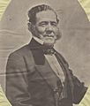
Californio politician Antonio María Pico, of the prominent Pico family of California, was granted Rancho Pescadero in 1843, encompassing the area of modern-day Tracy.

See also
 In Spanish: Tracy (California) para niños
