
Traer, Iowa facts for kids
Quick facts for kids
Traer, Iowa
|
|
|---|---|

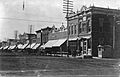
Downtown buildings including the Carnegie library and grain elevator
|
|

Location of Traer, Iowa
|
|
| Country | |
| State | |
| County | Tama |
| Area | |
| • Total | 1.29 sq mi (3.34 km2) |
| • Land | 1.29 sq mi (3.34 km2) |
| • Water | 0.00 sq mi (0.00 km2) |
| Elevation | 915 ft (279 m) |
| Population
(2020)
|
|
| • Total | 1,583 |
| • Density | 1,228.08/sq mi (474.02/km2) |
| Time zone | UTC-6 (Central (CST)) |
| • Summer (DST) | UTC-5 (CDT) |
| ZIP code |
50675
|
| Area code(s) | 319 |
| FIPS code | 19-78735 |
| GNIS feature ID | 0462294 |
Traer is a city in Tama County, Iowa, United States. The population was 1,583 at the time of the 2020 census.
Traer is known for the iron winding staircase that originally led to the office of the local newspaper. The staircase is freestanding, reverse-spiral and connected to the building with a suspended walkway, a somewhat rare arrangement.
Contents
History
Traer had its start in the year 1873 by the building of Burlington, Cedar Rapids and Northern Railway through that territory. The city was named for John W. Traer.
Geography
Traer is located at 42°11′29″N 92°27′52″W / 42.19139°N 92.46444°W (42.191495, -92.464374), in Perry Township.
According to the United States Census Bureau, the city has a total area of 1.18 square miles (3.06 km2), all of it land.
Important roads in Traer include U.S. Route 63 and Iowa Highway 8.
Demographics
| Historical populations | ||
|---|---|---|
| Year | Pop. | ±% |
| 1880 | 1,100 | — |
| 1890 | 1,014 | −7.8% |
| 1900 | 1,458 | +43.8% |
| 1910 | 1,283 | −12.0% |
| 1920 | 1,329 | +3.6% |
| 1930 | 1,417 | +6.6% |
| 1940 | 1,493 | +5.4% |
| 1950 | 1,627 | +9.0% |
| 1960 | 1,623 | −0.2% |
| 1970 | 1,682 | +3.6% |
| 1980 | 1,703 | +1.2% |
| 1990 | 1,552 | −8.9% |
| 2000 | 1,594 | +2.7% |
| 2010 | 1,703 | +6.8% |
| 2020 | 1,583 | −7.0% |
| Source: and Iowa Data Center Source: |
||

2010 census
As of the census of 2010, there were 1,703 people, 693 households, and 458 families living in the city. The population density was 1,443.2 inhabitants per square mile (557.2/km2). There were 778 housing units at an average density of 659.3 per square mile (254.6/km2). The racial makeup of the city was 98.0% White, 0.2% African American, 0.2% Native American, 0.4% Asian, 0.1% Pacific Islander, 0.1% from other races, and 1.1% from two or more races. Hispanic or Latino of any race were 0.8% of the population.
There were 693 households, of which 30.2% had children under the age of 18 living with them, 52.8% were married couples living together, 9.7% had a female householder with no husband present, 3.6% had a male householder with no wife present, and 33.9% were non-families. 30.0% of all households were made up of individuals, and 18.9% had someone living alone who was 65 years of age or older. The average household size was 2.35 and the average family size was 2.91.
The median age in the city was 43.5 years. 23.7% of residents were under the age of 18; 6.2% were between the ages of 18 and 24; 22.6% were from 25 to 44; 22.2% were from 45 to 64; and 25.1% were 65 years of age or older. The gender makeup of the city was 47.6% male and 52.4% female.
Education
Traer is within the North Tama County Community School District.
Infrastructure
Services provided by the city include a fire department, an ambulance service, a swimming pool, a public library, an airport, and two parks.
Notable people
- James "Tama Jim" Wilson lived in Traer after serving as U.S. Secretary of Agriculture and was buried in a cemetery northwest of the town in 1920.
- Margaret Wilson, who won the Pulitzer Prize for fiction in 1924, was born in Traer.
Images for kids
-
Main Street, 1910

See also
 In Spanish: Traer (Iowa) para niños
