
Tully, Queensland facts for kids
Quick facts for kids TullyQueensland |
|||||||||||||||
|---|---|---|---|---|---|---|---|---|---|---|---|---|---|---|---|

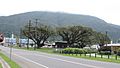
Tully's main street (Butler Street), 2006
|
|||||||||||||||

Tully
Location in Queensland
|
|||||||||||||||
| Population | 2,390 (2016 census) | ||||||||||||||
| Postcode(s) | 4854 | ||||||||||||||
| Elevation | 24 m (79 ft) | ||||||||||||||
| Location |
|
||||||||||||||
| LGA(s) | Cassowary Coast Region | ||||||||||||||
| State electorate(s) |
|
||||||||||||||
| Federal Division(s) | Kennedy | ||||||||||||||
|
|||||||||||||||
|
|||||||||||||||
Tully is a town and locality in the Cassowary Coast Region, Queensland, Australia. It is adjacent to the Bruce Highway, approximately 140 kilometres (87 mi) south of Cairns by road and 210 kilometres (130 mi) north of Townsville. At the 2016 census, the population was 2,390. Tully is perhaps best known for being one of the wettest towns in Australia and home to the 7.9 metre tall Golden Gumboot.
The Tully River (previously known as the Mackay River) was named after Surveyor-General William Alcock Tully in the 1870s. The town of Tully was named after the river when it was surveyed during the erection of the sugar mill in 1924 (although the river does not flow through the town or the locality). During the previous decade, a settlement known as Banyan had grown up on the other side of Banyan Creek.
Tully is one of the larger towns of the Cassowary Coast Region. The economic base of the region is agriculture: sugar cane and bananas are the dominant crops. The sugar cane grown at the many farms in the district is processed locally at the Tully Sugar Mill, and the raw sugar produced is shipped elsewhere for further refining.
History


The Tully River area was slowly settled once Cardwell, to the south, was established. The river was renamed in 1872 in honour of William Alcock Tully, then under-secretary for public lands and chief commissioner of crown lands in Queensland. The first settlers were the nephews of James Tyson who raised beef cattle. It was not until the government constructed a sugar mill in 1925 that the town began to develop.
Tully was originally within the Cardwell Division, which became the Shire of Cardwell in 1903. The original headquarters for the division/shire were in older town of Cardwell. In 1929, the decision was taken to relocate the shire council's headquarters to the newer but more populous town of Tully. The first council meeting held in Tully was on 27 June 1929. A new shire chambers was built in 1930 on the south-east corner of Bryant and Morris Streets.
At the 2011 census, Tully had a population of 2,436.
Tully remained the administrative centre for the Shire of Cardwell, until the shire was amalgamated into the Cassowary Coast Region in 2008. The regional council has its headquarters in Innisfail.
In March 2015, a farm at Tully tested positive for the soil-borne Panama disease. Follow-up testing confirmed the results. One of the strains of the disease affects all types of bananas and has previously only been detected in the Northern Territory. Harvesting continued on the property with strict protocols allowing the farm to continue to operate and distribute product without posing a threat.
Climate
Tully has a tropical rainforest climate. With an average annual rainfall exceeding 4,000 millimetres (160 in), and the highest ever annual rainfall in a populated area of Australia (7,900 millimetres (310 in) in 1950), Tully is arguably the wettest town in Australia – a rivalry exists between Tully and the nearby town of Babinda for said title in which most years Babinda wins. Although Tully's average rainfall is less than Babinda, in 2003 a giant gumboot (the "Golden Gumboot") was erected as a monument to the town's climate; it also serves as a museum documenting past floods, as well as displaying the current rainfall for the year.
| Climate data for Tully, Queensland | |||||||||||||
|---|---|---|---|---|---|---|---|---|---|---|---|---|---|
| Month | Jan | Feb | Mar | Apr | May | Jun | Jul | Aug | Sep | Oct | Nov | Dec | Year |
| Average high °C (°F) | 31.3 (88.3) |
30.8 (87.4) |
29.9 (85.8) |
28.3 (82.9) |
26.3 (79.3) |
24.5 (76.1) |
24.0 (75.2) |
25.3 (77.5) |
27.3 (81.1) |
29.1 (84.4) |
30.5 (86.9) |
31.3 (88.3) |
28.2 (82.8) |
| Average low °C (°F) | 22.7 (72.9) |
22.8 (73.0) |
22.1 (71.8) |
20.7 (69.3) |
18.6 (65.5) |
16.1 (61.0) |
15.1 (59.2) |
15.6 (60.1) |
16.9 (62.4) |
19.0 (66.2) |
20.8 (69.4) |
22.1 (71.8) |
19.4 (66.9) |
| Average precipitation mm (inches) | 605.7 (23.85) |
738.0 (29.06) |
752.6 (29.63) |
533.7 (21.01) |
329.9 (12.99) |
195.6 (7.70) |
152.0 (5.98) |
125.6 (4.94) |
114.2 (4.50) |
109.7 (4.32) |
176.8 (6.96) |
270.1 (10.63) |
4,103.9 (161.57) |
| Source: BOM (Bureau of Meteorology) | |||||||||||||
Cyclone Yasi
Buildings in Tully were badly damaged by Cyclone Yasi on 3 February 2011. According to residents, Tully was "...a scene of mass devastation". An unknown number of homes were completely destroyed as intense winds, estimated at 300 km/h (190 mph), battered the area. Many other homes not destroyed sustained severe façade and or roof damage. As daybreak came, reports from the town stated that about 90 per cent of the structures along the main avenue sustained extensive damage.
Transport

Tully Railway Station is a prominent station on the main North Coast Railway Line, situated just over halfway between Townsville and Cairns. By 10 December 1924, Tully was connected with both Townsville and Innisfail.
Heritage listings
Tully has a number of heritage-listed sites, including:
- 17 Mars Street: Tully State School
- 69 Bryant Street: Tully Court House
Sport
Tully is the hometown to Indigenous boxer and 2008 Olympian, Paul Fleming.
Tully Tigers, is the local Rugby League club. One of their most famous juniors is former Cowboys forward Peter Jones. Tully was once one of the biggest sporting hubs in Far North Queensland, but since the economic crisis has hit, they are looking for more and more ways to support their clubs.
Tully is the last place reclusive All Black rugby player Keith Murdoch has been sighted.
Images for kids
-
Butler Street, Tully, with Mount Tyson in the background with low cloud, 2016

