
Turtle Bay, Manhattan facts for kids
Quick facts for kids
Turtle Bay
|
|
|---|---|

Townhouses in Turtle Bay
|
|
| Country | |
| State | |
| City | New York City |
| Borough | Manhattan |
| Community District | Manhattan 6 |
| Area | |
| • Total | 1.04 km2 (0.403 sq mi) |
| Population
(2016)
|
|
| • Total | 24,856 |
| • Density | 23,814/km2 (61,680/sq mi) |
| Ethnicity | |
| • White | 77.1% |
| • Asian | 13.0% |
| • Hispanic | 5.8% |
| • Black | 2.1% |
| • Other | 0.4% |
| Economics | |
| • Median income | $135,360 |
| Time zone | UTC−5 (Eastern) |
| • Summer (DST) | UTC−4 (EDT) |
| ZIP Codes |
10017, 10022
|
| Area code | 212, 332, 646, and 917 |
Turtle Bay is a neighborhood in New York City, on the east side of Midtown Manhattan. It extends from roughly 43rd Street to 53rd Streets, and eastward from Lexington Avenue to the East River's western branch (facing Roosevelt Island). The neighborhood is the site of the headquarters of the United Nations and the Chrysler Building. The Tudor City apartment complex is to the south of Turtle Bay.
Turtle Bay is named after a former cove of the East River. The neighborhood was originally settled as a Dutch farm in the 17th century, and was subsequently developed with tenements, power plants, and slaughterhouses in the 19th century. These industrial structures were largely demolished in the 1940s and 1950s to make way for the United Nations headquarters. Today, Turtle Bay contains multiple missions and consulates to the nearby United Nations headquarters.
Turtle Bay is part of Manhattan Community District 6, and its primary ZIP Codes are 10017 and 10022. It is patrolled by the 17th Precinct of the New York City Police Department.
Contents
History
Colonial days
Turtle Bay, a cove of the East River, received its name in the 17th century by its resemblance in shape to that of a knife, "deutal" being Dutch for "knife". The cove, which was filled in after the Civil War, was a valuable shelter from the often harsh weather on the river, and became a thriving site for shipbuilding.
The Turtle Bay neighborhood was originally a 40-acre (16 ha) land grant given to two Englishmen by the Dutch colonial governor of New Amsterdam in 1639, and named "Turtle Bay Farm". The farm extended roughly from what is now 43rd Street to 48th Street, and from Third Avenue to the river.

On a knoll overlooking the cove, near 41st Street, the farmhouse was purchased as a summer retreat by Francis Bayard, and in the early 19th century remained the summer villa of Francis Bayard Winthrop. Turtle Creek, or DeVoor's Mill Creek as it was known, emptied into the cove at what is now 47th Street. To the south lay Kip's Bay farm; to the north, on a bluff, stood James Beekman's "Mount Pleasant", the first of a series of houses and villas with water views stretching away up the shoreline. After the street grid system was initiated in Manhattan, the hilly landscape of the Turtle Bay Farm was graded to create cross-streets and the land was subdivided for residential development.
Late 19th century
An army enrollment office was established at Third Avenue and 46th Street, after the first Draft Act was passed during the American Civil War. On July 13, 1863, an angry mob burned the office to the ground and proceeded to riot through the surrounding neighborhood, destroying entire blocks. The New York Draft Riots continued for three days before army troops managed to contain the mob, which had burned and looted much of the city.
After the war ended, the formerly pastoral neighborhood was developed with brownstones. By 1868 the bay had been entirely filled in by commercial overdevelopment, packed with breweries, gasworks, slaughterhouses, cattle pens, coal yards, and railroad piers. By the early 20th century, Turtle Bay was "a riverside back yard" for the city, as the WPA Guide to New York City (1939) described it: "huge industrial enterprises— breweries, laundries, abattoirs, power plants— along the water front face squalid tenements not far away from new apartment dwellings attracted to the section by its river view and its central position. The numerous plants shower this district with the heaviest sootfall in the city— 150 tons to the square mile annually".
The huge Waterside Station, a power plant operated by the Consolidated Edison Company, producing 367,000 kilowatts of electricity in its coal-fired plant, marked the southern boundary of the neighborhood. There were also 18 acres (73,000 m2) of slaughterhouses along First Avenue. With an infusion of poor immigrants having had come in the later part of the 19th century, and the opening of the elevated train lines along Second and Third Avenues, the neighborhood went into decay with crumbling tenement buildings.
20th and 21st centuries

Many tenements were restored in the 1920s, and a large communal garden was established. Charlotte Hunnewell Sorchan saw promise in the run-down rowhouses of Turtle Bay; in 1918 she purchased eleven houses on the south side of 49th Street and nine on the north side of 48th Street, between 2nd and 3rd Avenues; within two years she had renovated the enclave called Turtle Bay Gardens. Her architects refaced the brownstone street-fronts with pale stucco, and rearranged the interiors so that service rooms faced the noisy street and living areas faced inwards, where the individual back yards were arranged so that each opens into to a common garden of trees and shrubs down the center. Having married Walton Martin, she then sold the houses to friends at cost, with property restrictions that kept the commons secure. Among the first purchasers was Maria Bowen Chapin, founder of the Chapin School. Celebrity residents since have included actors Katharine Hepburn, Ruth Gordon, June Havoc, Ricardo Montalban, and Tyrone Power; writer-director Garson Kanin, composer Stephen Sondheim; jurist Learned Hand, conductor Leopold Stokowski; editor Maxwell Perkins; publisher Henry Luce; journalist Dorothy Thompson; and writer/journalist E. B. White, who wrote Charlotte's Web when living on 48th Street. It was designated the Turtle Bay Gardens Historic District in 1966.
An area between First and Second Avenues, and 41st and 43rd Streets was known as "Goat Hill" – goats and squatters ruled the area – and later renamed "Prospect Hill". Prospect Hill developed into a shanty Irish community known as "Corcoran's Roost", founded by Jimmy Corcoran, in the 1850s, and later became known as a community with a high rate of violent crime and a haven for waterfront thieves such as the Rag Gang, during the late 19th century. From 1927 to 1932, the 2,800-unit Tudor City was built on this site, which was in 1988 named a historic district.

The clearing of the slaughterhouses for the construction of the UN headquarters in 1948, largely completed by 1952, and the removal of the elevated trains opened the neighborhood up for high-rise office buildings and condominiums. Concurrent with the UN headquarters' construction, the Ralph Bunche Park staircase was constructed, connecting Tudor City to the rest of Turtle Bay. Until the Third Avenue el was demolished in 1956, it was characterized by a blighted stretch of sooty darkness that had separated the neighborhood from Midtown Manhattan.
After the UN headquarters' expansion plan was originally announced in 2000, it was opposed by some Turtle Bay residents over concerns about the loss of the current Robert Moses Playground in order to build a long-sought new UN building on the site. In October 2011, city and state officials announced an agreement in which the UN would be allowed to build the tower adjacent to the existing campus on the current playground. In exchange, the United Nations would allow the construction of an esplanade along the East River that would complete the East River Greenway, a waterfront pedestrian and bicycle pathway. While host nation authorities have agreed to the provisions of the plan, it needs the approval of the United Nations in order to be implemented. The plan is similar in concept to an earlier proposal that had been announced in 2000 but did not move forward.
Demographics
For census purposes, the New York City government classifies Turtle Bay as part of a larger neighborhood tabulation area called Turtle Bay-East Midtown. Based on data from the 2010 United States Census, the population of Turtle Bay-East Midtown was 51,231, a change of 1,494 (2.9%) from the 49,737 counted in 2000. Covering an area of 410.95 acres (166.31 ha), the neighborhood had a population density of 124.7 inhabitants per acre (79,800/sq mi; 30,800/km2). The racial makeup of the neighborhood was 77.1% (39,475) White, 2.1% (1,071) African American, 0% (23) Native American, 13% (6,655) Asian, 0% (21) Pacific Islander, 0.4% (184) from other races, and 1.6% (845) from two or more races. Hispanic or Latino of any race were 5.8% (2,957) of the population.
The entirety of Community District 6, which comprises Turtle Bay and Stuyvesant Town, had 53,120 inhabitants as of NYC Health's 2018 Community Health Profile, with an average life expectancy of 84.8 years. This is higher than the median life expectancy of 81.2 for all New York City neighborhoods. Most inhabitants are adults: a plurality (45%) are between the ages of 25–44, while 22% are between 45–64, and 13% are 65 or older. The ratio of youth and college-aged residents was lower, at 7% and 12% respectively.
As of 2017, the median household income in Community District 6 was $112,383, though the median income in Turtle Bay individually was $135,360 In 2018, an estimated 10% of Turtle Bay and Stuyvesant Town residents lived in poverty, compared to 14% in all of Manhattan and 20% in all of New York City. One in twenty-five residents (4%) were unemployed, compared to 7% in Manhattan and 9% in New York City. Rent burden, or the percentage of residents who have difficulty paying their rent, is 42% in Turtle Bay and Stuyvesant Town, compared to the boroughwide and citywide rates of 45% and 51% respectively. Based on this calculation, as of 2018[update], Turtle Bay and Stuyvesant Town are considered to be high-income relative to the rest of the city and not gentrifying.
Turtle Bay Association
The Turtle Bay Association, a neighborhood non-profit 501(c)3 organization, was founded in 1957 to protest, successfully, the widening of East 49th Street. It now serves as an advocate for residents of Turtle Bay, and maintains the neighborhood's quality of life. The Association's efforts have resulted in more park and landscaping development, creating the neighborhood's tree-lined and relatively quiet atmosphere.
Transportation

The closest New York City Subway stations are at the western border of the neighborhood, at Lexington Avenue/51st–53rd Streets (4, 6 <6>, E, and M trains) and Grand Central–42nd Street (4 5 6 <6>, 7 <7>, and S trains); the latter has a connection to the Metro-North Railroad at Grand Central Terminal. Local New York City Bus lines include M15, M15 SBS, M42, M50, M101, M102, M103.
The only major thoroughfare is the FDR Drive, at the neighborhood's eastern border. The Queens Midtown Tunnel (I-495) and Queensboro Bridge (NY 25) are located just south and north, respectively, of the neighborhood.
Diplomatic missions
Missions to the United States in Turtle Bay include:
- Consulate-General of the Bahamas
- Consulate-General of Germany
- Consulate-General of Israel in New York
- Consulate-General of Jamaica
- Consulate-General of Luxembourg
- Consulate-General of Nicaragua
- Consulate-General of Saudi Arabia
- Consulate-General of Singapore
- Consulate-General of Ukraine
- Consulate-General of the United Kingdom
Numerous missions to the United Nations are in Turtle Bay, close to the UN. They include:
- Albania
- Andorra
- Antigua and Barbuda
- Argentina
- Australia
- Azerbaijan
- The Bahamas
- Bahrain
- Bangladesh
- Barbados
- Belgium
- Belize
- Bhutan
- Bolivia
- Bosnia and Herzegovina
- Botswana
- Brazil
- Brunei Darussalam
- Burkina Faso
- Burundi
- Cambodia
- Canada
- Chad
- Chile
- Comoros
- Democratic Republic of the Congo
- Republic of the Congo
- Costa Rica
- Croatia
- Denmark
- Djibouti
- Dominica
- Dominican Republic
- Ecuador
- Egypt
- Equatorial Guinea
- Eritrea
- Ethiopia
- Finland
- France
- The Gambia
- Georgia
- Germany
- Greece
- Grenada
- Guinea
- Guyana
- Haiti
- Honduras
- Hungary
- Iceland
- India
- Republic of Ireland
- Israel
- Italy
- Jamaica
- Japan
- Jordan
- Kazakhstan
- Kenya
- Kuwait
- Kyrgyzstan
- Laos
- Latvia
- Lebanon
- Liberia
- Libya
- Lithuania
- Luxembourg
- Madagascar
- Malawi
- Malaysia
- Maldives
- Marshall Islands
- Mauritius
- Mexico
- Federated States of Micronesia
- Monaco
- Morocco
- Mozambique
- Nauru
- New Zealand
- Nicaragua
- North Korea
- Saudi Arabia
- Tonga
- Turkey
- United States
- Vietnam
In popular culture
- Turtle Bay is the setting for a considerable portion of the Kurt Vonnegut science fiction novel Slapstick, as well as the location of the (fictional) painter Dan Gregory's mansion (in the brownstones of 48th Street between 2nd and 3rd Avenues) in his novel Bluebeard.
- The animated series The Venture Bros.'s pilot episode is entitled "The Terrible Secret of Turtle Bay" and takes place largely at the UN headquarters.
- Turtle Bay is the location of a vacant lot in Stephen King's Dark Tower series, where the Tower takes the form of The Rose. Later, the lot is revealed to be the site of 1 Dag Hammarskjöld Plaza.
- In the song "Stars and The Moon" from the musical revue Songs for a New World by Jason Robert Brown, a rich suitor promises to buy the singer a "townhouse in Turtle Bay."
- Turtle Bay, and specifically Beekman Place, is home to the fictional character "Mame Dennis" in the novel Auntie Mame by Patrick Dennis, as well as in the Broadway play, musical and the films based on it.
- Turtle Bay is the home of the fictional lawyer Stone Barrington in a series of novels by Stuart Woods.
- Turtle Bay is the location of the "old willow tree" that is "long-suffering and much-climbed, held together by strings of wire but beloved of those who know it" that E.B. White writes "symbolizes the city" in his essay "Here is New York".
Education

Turtle Bay and Stuyvesant Town generally have a higher rate of college-educated residents than the rest of the city as of 2018[update]. A majority of residents age 25 and older (82%) have a college education or higher, while 3% have less than a high school education and 15% are high school graduates or have some college education. By contrast, 64% of Manhattan residents and 43% of city residents have a college education or higher. The percentage of Turtle Bay and Stuyvesant Town students excelling in math rose from 61% in 2000 to 80% in 2011, and reading achievement increased from 66% to 68% during the same time period.
Turtle Bay and Stuyvesant Town's rate of elementary school student absenteeism is lower than the rest of New York City. In Turtle Bay and Stuyvesant Town, 8% of elementary school students missed twenty or more days per school year, less than the citywide average of 20%. Additionally, 91% of high school students in Turtle Bay and Stuyvesant Town graduate on time, more than the citywide average of 75%.
Schools
The New York City Department of Education does not operate any public schools in Turtle Bay. Students in grades PK-5 are zoned to PS 59 Beekman Hill International in Lenox Hill and students in grades 6-8 are zoned to IS 104 Simon Baruch School in Gramercy Park. Formerly, P.S. 135 operated inside Turtle Bay. The structure now contains condominiums and is listed on the National Register of Historic Places.
There are no zoned high schools in New York City. However, the Art and Design High School, a vocational school, serves grades 9-12.
Libraries
The New York Public Library (NYPL) operates two branches near Turtle Bay:
- The 58th Street branch is located at 127 East 58th Street. The branch opened in a Carnegie library building in 1907 and moved to its current two-story space in 1969.
- The Grand Central branch is located at 135 East 46th Street. The two-story library opened in 2008.
Images for kids
-
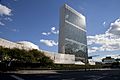
The United Nations Headquarters is located in Turtle Bay; pictured is the United Nations Secretariat Building.
-
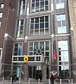
The German mission to the United Nations
.jpg)

See also
 In Spanish: Turtle Bay (Manhattan) para niños
