
Twentynine Palms, California facts for kids
Quick facts for kids
City of Twentynine Palms
|
||
|---|---|---|

Twentynine Palms looking east on Highway 62
|
||
|
||
| Motto(s):
"A Beautiful Desert Oasis"
|
||

Location in San Bernardino County and the state of California
|
||

Twentynine Palms, California
Location in the United States
|
||
| Country | United States | |
| State | California | |
| County | San Bernardino | |
| Incorporated | November 23, 1987 | |
| Government | ||
| • Type | Council–manager | |
| Area | ||
| • Total | 58.76 sq mi (152.18 km2) | |
| • Land | 58.76 sq mi (152.18 km2) | |
| • Water | 0.00 sq mi (0.00 km2) 0% | |
| Elevation | 1,988 ft (606 m) | |
| Population
(2010)
|
||
| • Total | 25,048 | |
| • Estimate
(2019)
|
26,073 | |
| • Density | 443.74/sq mi (171.33/km2) | |
| Time zone | UTC−8 (Pacific) | |
| • Summer (DST) | UTC−7 (PDT) | |
| ZIP codes |
92277-92278
|
|
| Area codes | 442/760 | |
| FIPS code | 06-80994 | |
| GNIS feature IDs | 1652804, 2412119 | |


Twentynine Palms (also known as 29 Palms) is a city in San Bernardino County, California. Twentynine Palms serves as one of the entry points to Joshua Tree National Park.
Contents
Geography
The city is located in the Mojave Desert in Southern California. It lies on the northern side of the Joshua Tree National Park and includes one of the entrances to the Park, at the Oasis of Mara.
According to the United States Census Bureau, the city has a total area of 59.1 square miles (153 km2), all land.
The city is at an elevation of 1,988 feet (606 m).
The Marine Corps Air Ground Combat Center Twentynine Palms is located there.
Climate
Due in large part to its elevation of more than 1,900 ft (580 m) above sea level, Twentynine Palms has a slightly cooler climate, especially during winter, than Palm Springs but with essentially the same subtropical desert characteristics. Temperatures reach 100 °F (38 °C) on 90 days, 90 °F (32 °C) on 155 days, and the freezing mark on 24 nights annually. Extremes range from 10 °F (−12 °C) on December 23, 1990 to 118 °F (48 °C) on July 11, 1961.
| Climate data for Twentynine Palms, California (1981–2010 normals) | |||||||||||||
|---|---|---|---|---|---|---|---|---|---|---|---|---|---|
| Month | Jan | Feb | Mar | Apr | May | Jun | Jul | Aug | Sep | Oct | Nov | Dec | Year |
| Record high °F (°C) | 85 (29) |
90 (32) |
95 (35) |
102 (39) |
112 (44) |
117 (47) |
118 (48) |
116 (47) |
114 (46) |
106 (41) |
93 (34) |
92 (33) |
118 (48) |
| Average high °F (°C) | 61.5 (16.4) |
65.3 (18.5) |
72.3 (22.4) |
79.8 (26.6) |
89.3 (31.8) |
98.0 (36.7) |
102.7 (39.3) |
101.0 (38.3) |
94.7 (34.8) |
82.8 (28.2) |
69.4 (20.8) |
60.1 (15.6) |
81.4 (27.4) |
| Daily mean °F (°C) | 51.1 (10.6) |
54.4 (12.4) |
60.3 (15.7) |
66.8 (19.3) |
75.9 (24.4) |
83.9 (28.8) |
89.4 (31.9) |
88.1 (31.2) |
81.4 (27.4) |
69.8 (21.0) |
57.8 (14.3) |
49.9 (9.9) |
69.1 (20.6) |
| Average low °F (°C) | 40.8 (4.9) |
43.4 (6.3) |
48.2 (9.0) |
53.8 (12.1) |
62.5 (16.9) |
69.7 (20.9) |
76.2 (24.6) |
75.2 (24.0) |
68.0 (20.0) |
56.8 (13.8) |
46.3 (7.9) |
39.7 (4.3) |
56.7 (13.7) |
| Record low °F (°C) | 11 (−12) |
18 (−8) |
23 (−5) |
29 (−2) |
33 (1) |
43 (6) |
53 (12) |
52 (11) |
38 (3) |
24 (−4) |
14 (−10) |
10 (−12) |
10 (−12) |
| Average precipitation inches (mm) | 0.52 (13) |
0.57 (14) |
0.45 (11) |
0.13 (3.3) |
0.09 (2.3) |
0.01 (0.25) |
0.54 (14) |
0.80 (20) |
0.39 (9.9) |
0.18 (4.6) |
0.24 (6.1) |
0.57 (14) |
4.49 (112.45) |
| Average precipitation days (≥ 0.01 in) | 3.2 | 3.2 | 2.5 | 1.2 | 0.8 | 0.2 | 1.6 | 2.6 | 1.6 | 1.1 | 1.2 | 2.4 | 21.6 |
| Source: NOAA (extremes 1935–present) | |||||||||||||
History
Twentynine Palms was named for the palm trees found there in 1852 by Col. Henry Washington while surveying the San Bernardino base line. A post office was established in 1927.
Nearby is a small Indian reservation belonging to the Twentynine Palms Band of Mission Indians.
The Joshua Tree National Park wilderness area which lies just alongside to the South of Twentynine Palms was designated a National Monument in 1936 and became a National Park in 1994.
The nearby Marine Corps Air Ground Combat Center Twentynine Palms was founded in 1952.
Demographics
| Historical population | |||
|---|---|---|---|
| Census | Pop. | %± | |
| 1970 | 5,667 | — | |
| 1980 | 7,465 | 31.7% | |
| 1990 | 11,821 | 58.4% | |
| 2000 | 14,764 | 24.9% | |
| 2010 | 25,048 | 69.7% | |
| 2019 (est.) | 26,073 | 4.1% | |
| U.S. Decennial Census | |||
Its population as of July 1, 2013 was estimated at 25,768.
2010 census
At the 2010 census, there were 25,048 people in 8,095 households, including 5,847 families, in the city. The population density was 423.5 people per square mile (163.5/km2). There were 9,431 housing units at an average density of 159.5 per square mile, of the occupied units 2,742 (33.9%) were owner-occupied and 5,353 (66.1%) were rented. The homeowner vacancy rate was 3.6%; the rental vacancy rate was 9.2%. 6,876 people (27.5% of the population) lived in owner-occupied housing units and 14,825 people (59.2%) lived in rental housing units. The racial makeup of the city was 71.6%, White (60.8% non-Hispanic), 8.2% African American, 1.3% Native American, 3.9% Asian, 1.4% Pacific Islander, 6.7% from other races, and 6.9% from two or more races. Hispanic or Latino of any race were 20.8% of the population.
The census reported that 21,701 people (86.6% of the population) lived in households, and 3,347 (13.4%) lived in non-institutionalized group quarters.
Of the 8,095 households 43.3% had children under the age of 18 living in them, 54.5% were opposite-sex married couples living together, 12.9% had a female householder with no husband present, 4.9% had a male householder with no wife present. There were 5.0% unmarried opposite-sex partnerships, and 1.6% same-sex married couples or partnerships. 21.1% of households were one person and 5.6% were one person aged 65 or older. The average household size was 2.68 and the average family size was 3.10.
The age distribution was 25.6% under the age of 18, 30.0% aged 18 to 24, 25.5% aged 25 to 44, 13.1% aged 45 to 64, and 5.8% who were 65 or older. The median age was 23.5 years. For every 100 females, there were 129.0 males. For every 100 females age 18 and over, there were 139.9 males.
The median household income was $42,572. About 14.4% of the population were living below the poverty line.
In popular culture
Music
A song, "The Lady from 29 Palms", was written by Allie Wrubel in 1947 and recorded by such artists as Frank Sinatra, Freddy Martin, Tony Pastor, and The Andrews Sisters.
The album Lily on the Beach by German electronic music ensemble Tangerine Dream contains an instrumental piano ballad called "Twenty-Nine Palms".
Former Led Zeppelin singer Robert Plant had a hit single called "29 Palms", from his solo album Fate of Nations in 1993.
The band Sublime mentioned the city of Twentynine Palms, CA in their song "April 29, 1992 (Miami)" off of their self-titled album, and also in their song "Thanx" off of their 40 oz. to Freedom album.
Track two of the album "Places" by Brad Mehldau, released in 2000, is named after the city.
In 2006, the pop punk band Forever Came Calling was founded here.
Film
Some scenes in the 1963 comedy film It's a Mad, Mad, Mad, Mad World were shot in Twentynine Palms.
Some scenes in the 1964 comedy film "Kiss Me, Stupid" were shot in Twentynine Palms.
Twentynine Palms is a 2003 drama/horror film set in Twentynine Palms.
Radio
On April 22, 1945, The Jack Benny Program was broadcast from Twentynine Palms Auxiliary Naval Air Station. There were jokes about the base's dry, hot weather, along with a comedic sketch of the town's history.
Economy
The Oasis of Mara, the original source of water and the historic source of all economic activity in the area, is divided into two parts: to the east, a long strip of palm trees terminating at one by the Joshua Tree National Park Visitor's Center, which is visited by approximately 140,000 people every year, and maintained by the United States National Park Service. To the west, the remainder of the oasis is owned by the 29 Palms Inn, an historic hotel, and ends in a large shaded pond.
The current economy depends largely on the nearby Marine Corps Air Ground Combat Center, as well as tourism associated with Joshua Tree National Park. In February 2015, the city set in place rules governing vacation rentals, and has granted approximately one hundred permits, compared to over one thousand in the nearby community of Joshua Tree.
Cultural attractions
The city has a series of 26 outdoor murals painted on local buildings featuring various aspects of desert life and history.
The 29 Palms Historical Society, housed in the original schoolhouse of the city, maintains a museum devoted to local history. The Historical Society also hosts an annual "Weed Show" each November devoted to art work composed of weeds. The Twentynine Palms Artists' Guild maintains exhibits devoted to local artists.
Education
- Twentynine Palms High School
- Copper Mountain College is a community college serving the Morongo Basin.
- The Morongo Unified School District provides an education for public school students.
- Mayfield College offers a training program to prepare active duty service members for careers in the Heating, Ventilation, Air Conditioning, and Refrigeration (HVAC/R) industry.
Transportation
 State Route 62 runs east–west through the town.
- Bus service is provided by the Morongo Basin Transit Authority (MBTA).
Notable people
- Willie Boy, subject of the novel Willie Boy; A Desert Manhunt, and the film Tell Them Willie Boy Is Here. He was a Piute-Chemehuevi Native American born in 29 Palms.
- Doug Cockle, actor and director
- Paramhansa Yogananda, Indian yoga master and teacher who lived in America from 1920 to 1952, had a desert retreat in Twentynine Palms.
- Mike Evans, actor and writer, was a longtime resident and died at his mother's house in Twentynine Palms.
- Cliff Raven, noted American tattoo pioneer, lived and worked in Twentynine Palms in his later years.
- Dick Dale, Legendary "King Of The Surf Guitar", lived on a ranch in 29 Palms until he died in March 2019.
- Elizabeth Warder Crozer Campbell, logged thousands of archeological finds in the 1920s in Joshua Tree Park. Wrote The Desert Was Home.
Images for kids
-
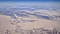
Aerial view of Twentynine Palms from the south, with Mojave Desert behind

See also
 In Spanish: Twentynine Palms para niños
