
Twizel facts for kids
Quick facts for kids
Twizel
|
|
|---|---|
 |
|
| Country | New Zealand |
| Region | Canterbury |
| Territorial authority | Mackenzie District |
| Ward | Pukaki Ward |
| Founded | 1968 |
| Area | |
| • Total | 21.08 km2 (8.14 sq mi) |
| Elevation | 470 m (1,540 ft) |
| Population
(June 2023)
|
|
| • Total | 1,850 |
| • Density | 87.76/km2 (227.3/sq mi) |
| Time zone | UTC+12 (NZST) |
| • Summer (DST) | UTC+13 (NZDT) |
| Postcode(s) |
7901
|
| Area code(s) | 03 |

Twizel is the largest town in the Mackenzie District, in the Canterbury Region of the South Island of New Zealand. The town was founded in 1968 to house construction workers on the Upper Waitaki Hydroelectric Scheme. Twizel has a resident population of 1,850 (June 2023); during the summer, holidaymakers nearly triple the town's population. Twizel is 37 km (29 minutes drive) east of Lake Ōhau, 30 km (20 minutes drive) north of Omarama and 60 km (42 minutes drive) south of Lake Tekapo.
Contents
History
The present town was built in 1968 as a greenfields project to service the Upper Waitaki Hydroelectricity Scheme. The scheme consisted of 50 km of canals, two dams, and four powerhouses (Tekapo B, Ohau A, B and C), and the formation of Lake Ruataniwha, producing 848 MW of electricity. At the height of the project in the 1970s, population peaked of around 6,000.
The town was laid out in a 'Scandinavian' fashion, featuring looping roads and pedestrian ways, making it usually far more direct to walk than use a car. Shops, school, and recreational parkland formed a hub in the centre of the town, around which the residential area were built. A previous version of this layout had been tried at Otematata. Accommodation was highly segregated: in addition to single men's quarters in the middle of town, there was a series of different houses available, with the smallest for workers, staff houses for teachers and professionals, and the largest for engineers and other high-status residents.
As the intention was for the town to revert to farmland, there were many 'temporary' features. For example, instead of putting in kerbing, channels, and footpaths at the edge of the road, a single expanse of seal was contoured in a very flat 'W' shape: the seal was highest at the outer edge (footpath) and in the middle (centreline), with a lower area serving as a channel and delineation between the roadway and footpath. Likewise, most of the town's telephone local loop is strung above ground to save the task of burying and then removing the lines. Most houses were prefabricated, and intended to be portable. Some were brought from Otematata, and some were later moved to Clyde for the next hydroelectricity project. However, in 1983, as the hydroelectric project was winding up, residents successfully fought to save the town itself.
Tourism and activities
Twizel is a now a service and tourist town for visitors. Nearby Lake Ruataniwha supports sailing, water skiing and prominent rowing events such as the Maadi Cup, while the Ohau Skifield and the Round Hill Ski Area attract winter tourists.
Twizel is also on the route of the Alps to Ocean Cycle Trail,
The area boasts one of the world's cleanest, driest and darkest skies, and has long drawn astronomers to Twizel and the surrounding area, with several existing astro-tourism ventures, such as at Lake Tekapo and Omarama, catering to their needs during the development of two additional observatories in Twizel and at Mount Cook Village. Since 2012, Twizel has been a part of the Aoraki Mackenzie International Dark-Sky Reserve, one of only five such reserves in the world recognised by the International Dark-Sky Association.
Transport
Road
Twizel sits immediately to the west of State Highway 8 which is the main highway serving the town. Twizel is served by InterCity coaches with regular service to Christchurch and Queenstown. The Cook Connection bus service also provides connections to Mount Cook village from Twizel.

Airport
Twizel is served by the nearby Pukaki Airport.
Demographics
Twizel is described by Statistics New Zealand as a small urban area, and covers 21.08 km2 (8.14 sq mi) and had an estimated population of 1,850 as of June 2023, with a population density of 88 people per km2.
| Historical population | ||
|---|---|---|
| Year | Pop. | ±% p.a. |
| 2006 | 1,041 | — |
| 2013 | 1,152 | +1.46% |
| 2018 | 1,455 | +4.78% |
Twizel had a population of 1,455 at the 2018 New Zealand census, an increase of 303 people (26.3%) since the 2013 census, and an increase of 414 people (39.8%) since the 2006 census. There were 609 households. There were 765 males and 687 females, giving a sex ratio of 1.11 males per female. The median age was 46.5 years (compared with 37.4 years nationally), with 213 people (14.6%) aged under 15 years, 243 (16.7%) aged 15 to 29, 681 (46.8%) aged 30 to 64, and 318 (21.9%) aged 65 or older.
Ethnicities were 87.6% European/Pākehā, 9.1% Māori, 0.8% Pacific peoples, 8.0% Asian, and 3.5% other ethnicities (totals add to more than 100% since people could identify with multiple ethnicities).
The proportion of people born overseas was 22.3%, compared with 27.1% nationally.
Although some people objected to giving their religion, 54.2% had no religion, 34.2% were Christian, 1.4% were Hindu, 1.0% were Buddhist and 2.5% had other religions.
Of those at least 15 years old, 222 (17.9%) people had a bachelor or higher degree, and 240 (19.3%) people had no formal qualifications. The median income was $31,400, compared with $31,800 nationally. 171 people (13.8%) earned over $70,000 compared to 17.2% nationally. The employment status of those at least 15 was that 690 (55.6%) people were employed full-time, 222 (17.9%) were part-time, and 9 (0.7%) were unemployed.
Education
Twizel Area School is the sole school in Twizel, catering for Year 1 to 13 students (ages 5 to 18).Twizel Primary School and Twizel High School were established in 1970. These were merged in 1986 to form the Twizel Area School. The co-educational school has a roll of 236 students as of April 2023. In April 2020, a commissioner was made responsible for the governance of Twizel Area School. The appointment of the commissioner was made at the request of its Board of Trustees. In March 2021, Twizel Area School returned to being run by the Board of Trustee with the commissioner stating that "The future of the school is bright and there is a lot to look forward to".
In July 2020, the New Zealand government announced a $21 million rebuild of the Twizel Area School. The relocatable classrooms would be replaced. In August 2021, the school was still awaiting plans to be developed and there was yet to be a timeframe for when construction would begin.
Images for kids
-

Twizel, surrounded by trees with the Southern Alps in the background
-
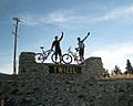
Cyclists in Twizel, New Zealand
-
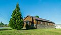
All Saints Church, Twizel


