Union County, Indiana facts for kids
Quick facts for kids
Union County
|
|
|---|---|

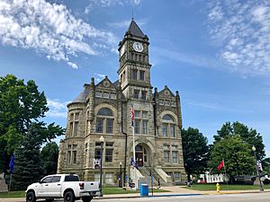
Union County Courthouse in Liberty
|
|

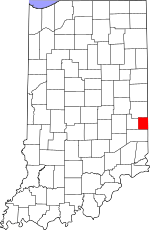
Location within the U.S. state of Indiana
|
|
 Indiana's location within the U.S. |
|
| Country | |
| State | |
| Founded | 5 January 1821 (created) 1 February 1821 (organized) |
| Seat | Liberty |
| Largest town | Liberty |
| Area | |
| • Total | 165.18 sq mi (427.8 km2) |
| • Land | 161.22 sq mi (417.6 km2) |
| • Water | 3.95 sq mi (10.2 km2) 2.39%% |
| Population | |
| • Estimate
(2018)
|
7,037 |
| • Density | 43.6/sq mi (16.8/km2) |
| Time zone | UTC−5 (Eastern) |
| • Summer (DST) | UTC−4 (EDT) |
| Congressional district | 6th |
| Indiana county number 81 | |

Union County is a county in the U.S. state of Indiana. As of the 2010 United States Census, the population was 7,516. The county seat is Liberty.
Since 2018, Union County has been included in the Cincinnati-Middletown, OH-KY-IN Metropolitan Statistical Area. It is located on the Indiana-Ohio border.
Contents
History
Union County was formed in 1821. It was so named because it is the product of a union of parts of Fayette, Franklin and Wayne counties. The first settlers were from Laurens District, South Carolina. John Templeton was the first settler to enter land at the Cincinnati land office in what would become Harmony Township, Union County Indiana. The first county seat was Brownsville, a small town located on the East Fork of the Whitewater River. The seat was moved in 1824 to Liberty, a central location. The primary industry of Union County was and is farming.
Union County is the birthplace of Thomas Warren Bennett, Mary Alice Smith (Little Orphan Annie), Cincinnatus Hiner "Joaquin" Miller, Jay Hall Connaway, Major General Frederick Leroy Martin and Ambrose Burnside.
Geography
According to the 2010 census, the county has a total area of 165.18 square miles (427.8 km2), of which 161.22 square miles (417.6 km2) (or 97.60%) is land and 3.95 square miles (10.2 km2) (or 2.39%) is water.
Adjacent counties
- Wayne County (north)
- Preble County, Ohio (east)
- Butler County, Ohio (southeast)
- Franklin County (south)
- Fayette County (west)
Cities and towns
Unincorporated
|
Townships
- Brownsville
- Center
- Harmony
- Harrison
- Liberty
- Union
Major highways
Climate and weather
| Weather chart for Liberty, Indiana | |||||||||||||||||||||||||||||||||||||||||||||||
|---|---|---|---|---|---|---|---|---|---|---|---|---|---|---|---|---|---|---|---|---|---|---|---|---|---|---|---|---|---|---|---|---|---|---|---|---|---|---|---|---|---|---|---|---|---|---|---|
| J | F | M | A | M | J | J | A | S | O | N | D | ||||||||||||||||||||||||||||||||||||
|
3
36
17
|
2.7
42
20
|
3.8
53
29
|
4
64
38
|
4.9
74
48
|
4.1
83
58
|
4.3
87
62
|
3.9
85
60
|
2.7
79
52
|
3
67
40
|
3.7
53
32
|
3.3
41
23
|
||||||||||||||||||||||||||||||||||||
| temperatures in °F precipitation totals in inches source: The Weather Channel |
|||||||||||||||||||||||||||||||||||||||||||||||
|
Metric conversion
|
|||||||||||||||||||||||||||||||||||||||||||||||
In recent years, average temperatures in Liberty have ranged from a low of 17 °F (−8 °C) in January to a high of 87 °F (31 °C) in July, although a record low of −31 °F (−35 °C) was recorded in January 1994 and a record high of 104 °F (40 °C) was recorded in September 1951. Average monthly precipitation ranged from 2.68 inches (68 mm) in September to 4.90 inches (124 mm) in May.
Demographics
| Historical population | |||
|---|---|---|---|
| Census | Pop. | %± | |
| 1830 | 7,944 | — | |
| 1840 | 8,017 | 0.9% | |
| 1850 | 6,944 | −13.4% | |
| 1860 | 7,109 | 2.4% | |
| 1870 | 6,341 | −10.8% | |
| 1880 | 7,673 | 21.0% | |
| 1890 | 7,006 | −8.7% | |
| 1900 | 6,748 | −3.7% | |
| 1910 | 6,260 | −7.2% | |
| 1920 | 6,021 | −3.8% | |
| 1930 | 5,880 | −2.3% | |
| 1940 | 6,017 | 2.3% | |
| 1950 | 6,412 | 6.6% | |
| 1960 | 6,457 | 0.7% | |
| 1970 | 6,582 | 1.9% | |
| 1980 | 6,860 | 4.2% | |
| 1990 | 6,976 | 1.7% | |
| 2000 | 7,349 | 5.3% | |
| 2010 | 7,516 | 2.3% | |
| 2015 (est.) | 7,182 | −4.4% | |
| U.S. Decennial Census 1790-1960 1900-1990 1990-2000 2010-2013 |
|||
As of the 2010 United States Census, there were 7,516 people, 2,938 households, and 2,117 families residing in the county. The population density was 46.6 inhabitants per square mile (18.0/km2). There were 3,239 housing units at an average density of 20.1 per square mile (7.8/km2). The racial makeup of the county was 97.5% white, 0.4% black or African American, 0.3% Asian, 0.3% American Indian, 0.1% Pacific islander, 0.3% from other races, and 1.1% from two or more races. Those of Hispanic or Latino origin made up 1.1% of the population. In terms of ancestry, 26.2% were German, 16.0% were Irish, 11.9% were English, and 11.6% were American.
Of the 2,938 households, 34.4% had children under the age of 18 living with them, 56.0% were married couples living together, 11.7% had a female householder with no husband present, 27.9% were non-families, and 23.9% of all households were made up of individuals. The average household size was 2.54 and the average family size was 2.99. The median age was 40.3 years.
The median income for a household in the county was $47,697 and the median income for a family was $49,815. Males had a median income of $39,603 versus $27,394 for females. The per capita income for the county was $19,243. About 8.2% of families and 11.9% of the population were below the poverty line, including 21.2% of those under age 18 and 10.0% of those age 65 or over.
Education
Union County is served by the Union County–College Corner Joint School District, the only joint state school district in the state.
Notable people
- Ambrose Everett Burnside (1824–1881), soldier, railroad executive, inventor, industrialist, politician
- Thomas W. Bennett (territorial governor) (1831–1893), governor of Idaho Territory 1871–1875; born in Union County
- Hiram Rhodes Revels (1827–1901), first African-American member of the US Senate, representing Mississippi 1870–1871; attended the Union County Quaker Seminary.
- Bill Bartlett (fl. 1970s-2010s), musician, guitarist for Ram Jam
- Jay Hall Connaway (1893–1970), Realist painter
- Mary Alice Smith (1850-_), aka Little Orphant Annie
- Bob Jenkins (1947–2021), television and radio sports announcer for ESPN/ABC Sports
- Edward E. Moore (1866–1940), Indiana state senator and Los Angeles City Council member
See also
 In Spanish: Condado de Union (Indiana) para niños

