
Union County, Tennessee facts for kids
Quick facts for kids
Union County
|
|||
|---|---|---|---|
| County of Union | |||

Union County Courthouse in Maynardville
|
|||
|
|||

Location within the U.S. state of Tennessee
|
|||
 Tennessee's location within the U.S. |
|||
| Country | |||
| State | |||
| Founded | 1850 | ||
| Named for | Either its creation from parts of five other counties or its support for the Union during the Civil War | ||
| Seat | Maynardville | ||
| Largest city | Maynardville | ||
| Area | |||
| • Total | 247 sq mi (640 km2) | ||
| • Land | 224 sq mi (580 km2) | ||
| • Water | 24 sq mi (60 km2) 9.5%% | ||
| Population
(2020)
|
|||
| • Total | 19,802 |
||
| • Density | 85/sq mi (33/km2) | ||
| Time zone | UTC−5 (Eastern) | ||
| • Summer (DST) | UTC−4 (EDT) | ||
| ZIP Codes |
37721, 37779, 37807, 37866, 37705
|
||
| Area code | 865 | ||
| Congressional district | 3rd | ||


Union County is a county located in the U.S. state of Tennessee. As of the 2010 census, its population was 19,109. Its county seat is Maynardville. Union County is included in the Knoxville metropolitan statistical area.
Contents
History
Union County was formed in 1850 from portions of Grainger, Claiborne, Campbell, Anderson and Knox counties. There are at least two theories on the source of its name. The name may commemorate the "union" of sections of five counties, or it may reflect East Tennessee's support for the preservation of the Union in the years before the Civil War. The county seat was originally named "Liberty," but renamed "Maynardville" in honor of attorney and congressman, Horace Maynard, who had defended the county in a court case that sought to block its formation.
In the 1930s, the damming of the Clinch River by Norris Dam to form Norris Lake inundated a large part of the county, including the community of Loyston, and displaced many residents. With assistance from the National Park Service and the Civilian Conservation Corps (CCC), the Tennessee Valley Authority (TVA) developed Big Ridge State Park as a demonstration park on the shore of the lake in Union County. The park's recreational facilities opened in May 1934.
Geography
According to the U.S. Census Bureau, the county has a total area of 247 square miles (640 km2), of which 224 square miles (580 km2) is land and 24 square miles (62 km2) (9.5%) is water. The county is situated in the Ridge-and-Valley Appalachians, a range characterized by long, narrow ridges alternating with similarly-shaped valleys. Prominent ridges in Union County include Copper Ridge, Hinds Ridge and Lone Mountain. The southern end of Clinch Mountain forms part of the county's border with Grainger County to the east.

The Clinch River, Union County's primary stream, flows through the northern part of the county. This section of the river is part of Norris Lake. Big Ridge Dam, a small non-generating dam, impounds an inlet of Norris Lake, creating Big Ridge Lake at Big Ridge State Park. The "Loyston Sea," one of the widest sections of Norris Lake, is located in Union County just north of the state park.
Adjacent counties
- Claiborne County (north)
- Grainger County (east)
- Knox County (south)
- Anderson County (southwest)
- Campbell County (northwest)
State protected areas
- Big Ridge State Park
- Chuck Swan State Forest (part)
Demographics
| Historical population | |||
|---|---|---|---|
| Census | Pop. | %± | |
| 1860 | 6,117 | — | |
| 1870 | 7,605 | 24.3% | |
| 1880 | 10,260 | 34.9% | |
| 1890 | 11,459 | 11.7% | |
| 1900 | 12,894 | 12.5% | |
| 1910 | 11,414 | −11.5% | |
| 1920 | 11,615 | 1.8% | |
| 1930 | 11,371 | −2.1% | |
| 1940 | 9,030 | −20.6% | |
| 1950 | 8,670 | −4.0% | |
| 1960 | 8,498 | −2.0% | |
| 1970 | 9,072 | 6.8% | |
| 1980 | 11,707 | 29.0% | |
| 1990 | 13,694 | 17.0% | |
| 2000 | 17,808 | 30.0% | |
| 2010 | 19,109 | 7.3% | |
| 2020 | 19,802 | 3.6% | |
| U.S. Decennial Census 1790-1960 1900-1990 1990-2000 2010-2014 |
|||

2020 census
| Race | Number | Percentage |
|---|---|---|
| White (non-Hispanic) | 18,642 | 94.14% |
| Black or African American (non-Hispanic) | 53 | 0.27% |
| Native American | 33 | 0.17% |
| Asian | 36 | 0.18% |
| Pacific Islander | 5 | 0.03% |
| Other/Mixed | 629 | 3.18% |
| Hispanic or Latino | 404 | 2.04% |
As of the 2020 United States census, there were 19,802 people, 7,405 households, and 5,471 families residing in the county.
Attractions
- Roy Acuff Museum
- Union County Arts Co-operative
- Big Ridge State Park
Communities

Cities
- Luttrell
- Maynardville (county seat)
- Plainview
Unincorporated communities
Ghost town
Economy
Top employers
According to a data profile produced by the Tennessee Department of Economic and Community Development in 2018, the top employers in the county are:
| Employer | Employees | |
|---|---|---|
| 1 | Union County School District | 350 |
| 2 | Clayton Homes (Maynardville) | 350 |
| 3 | Union County | 150 |
| 4 | Food City | 100 |
| 5 | O-N Minerals Company | 100 |
Education
- Big Ridge Elementary School
- Horace Maynard Middle School (previously Horace Maynard High School until 1997)
- Luttrell Elementary School
- Maynardville Elementary School
- Paulette Elementary School
- Sharps Chapel Elementary School
- Tennessee Virtual Academy
- Union County Alternative Center, grades 6-12
- Union County High School
Notable people
- Roy Acuff, entertainer
- Chet Atkins, entertainer
- Jake Butcher, former banker and politician, convicted of fraud
- Kenny Chesney, entertainer
- John Rice Irwin, historian and founder of Museum of Appalachia
- Florence Reece, who wrote the song "Which Side Are You On?", was born in Sharps Chapel in 1900.
- Carl Smith, entertainer
Images for kids
-
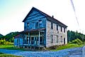
The old Hamilton-Lay store at Hamilton Crossroads, east of Maynardville

See also
 In Spanish: Condado de Union (Tennessee) para niños
