Union Township, Union County, New Jersey facts for kids
Quick facts for kids
Union Township, New Jersey
|
|
|---|---|
|
Township
|
|
| Township of Union | |
|
|
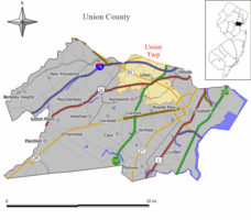
Map of Union Township in Union County. Inset: Location of Union County highlighted in the State of New Jersey.
|
|
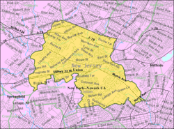
Census Bureau map of Union Township, Union County, New Jersey
|
|
| Country | |
| State | |
| County | |
| Incorporated | November 23, 1808 |
| Government | |
| • Type | Township |
| • Body | Township Committee |
| Area | |
| • Total | 9.08 sq mi (23.52 km2) |
| • Land | 9.05 sq mi (23.44 km2) |
| • Water | 0.03 sq mi (0.08 km2) 0.35% |
| Area rank | 219th of 565 in state 3rd of 21 in county |
| Elevation | 125 ft (38 m) |
| Population | |
| • Total | 56,642 |
| • Estimate
(2019)
|
58,488 |
| • Rank | 25th of 566 in state 2nd of 21 in county |
| • Density | 6,244.3/sq mi (2,410.9/km2) |
| • Density rank | 80th of 566 in state 9th of 21 in county |
| Time zone | UTC−05:00 (Eastern (EST)) |
| • Summer (DST) | UTC−04:00 (Eastern (EDT)) |
| ZIP Code |
07083: Union
07088: Vauxhall |
| Area code(s) | 908 |
| FIPS code | 3403974480 |
| GNIS feature ID | 0882212 |
| Website | |
Union Township is a township in Union County, New Jersey, United States. In the 18th century, the area that is now Union was then called Connecticut Farms. As of the 2010 United States Census, the township population was 56,642, the highest recorded in any decennial census, reflecting an increase of 2,237 (+4.1%) from the 54,405 counted in the 2000 Census, which had in turn increased by 4,381 (+8.8%) from the 50,024 counted in the 1990 Census.
Contents
History
Settled in 1667, Union was the third English speaking settlement in New Jersey after Elizabeth and Newark, with the area that is now Union then called Connecticut Farms.
Union Township was the site of the Battle of Connecticut Farms, one of the last battles between British and American forces during the American Revolutionary War. On June 6, 1780, British troops, led by Hessian General Wilhelm von Knyphausen, boarded boats on Staten Island bound for Elizabeth, New Jersey. At midnight, 5,000 troops started to land. They expected the Continental Army to give little resistance, believing that they were tired of the war and were poorly fed and paid. They also expected the citizens of New Jersey to welcome them. They were wrong on both counts and were unable to make their way to and through the Hobart Gap.
Union Township was incorporated as a township by an act of the New Jersey Legislature on November 23, 1808, from portions of Elizabeth Township, while the area was still part of Essex County. It became part of the newly formed Union County on March 19, 1857. Portions of the township have been taken to form Linden Township (March 4, 1861), Roselle Park, (March 22, 1901), Kenilworth (May 13, 1907) and Hillside (April 3, 1913). In 1946, a group of residents pushed for the township's name to be changed to "Connecticut Farms", citing the potential benefits to area residents and businesses from the broad awareness of the historical significance of the name.
Geography
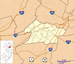
The Township of Union is located on the northern-central edge of Union County and is bordered by eight municipalities: Hillside to the east, Elizabeth to the southeast, Roselle Park and Kenilworth to the south and Springfield Township to the west. Northwest of the township lies Millburn, to the north lies Maplewood and to the northeast lies Irvington, all in Essex County.
According to the United States Census Bureau, Union township had a total area of 9.092 square miles (23.548 km2), including 9.071 square miles (23.494 km2) of land and 0.021 square miles (0.055 km2) of water (0.23%).
Unincorporated communities, localities and place names located partially or completely within the township include Battle Hill, Connecticut Farms, Galloping Hill, Headlentown, Putnam Manor, Salem, Townley and Vauxhall.
Neighborhoods
- Five Points, area around the junction of Galloping Hill Road, Chestnut Street, Salem Road, Delaware Avenue, Walton Avenue, and Tucker Avenue.
- Brookside Heights (Curreyville), west of Vauxhall Road.
- Vauxhall, area of Union north of I-78 and west of Stuyvesant Avenue,with its own ZIP code 07088.
- Union Center, area around the intersection of Morris and Stuyvesant Avenues.
- Putnam Ridge, a section between Suburban Road, Morris Avenue, Twin Oaks Road, and Colonial Avenue.
- Putnam Manor, an historic section between Colonial Avenue and Salem Road.
- Orchard Park
- Parkside Manor, a three-road section off of Union Terrace, featured in the movie She Devil with Roseanne Barr.
- Larchmont Estates, area bordered by Larchmont Reservation (NW and NE edges), Morris Avenue (SW), Liberty Avenue (SE), and Joe Collins Park/Larchmont Reservation (NE edge).
- Green Lane, new community between Kean University and Union Station.
- Fairway Drive, community bordering the Galloping Hill Golf Course.
Demographics
| Historical population | |||
|---|---|---|---|
| Census | Pop. | %± | |
| 1810 | 1,428 | — | |
| 1820 | 1,567 | 9.7% | |
| 1830 | 1,409 | −10.1% | |
| 1840 | 1,482 | 5.2% | |
| 1850 | 1,662 | 12.1% | |
| 1860 | 1,812 | 9.0% | |
| 1870 | 2,314 | 27.7% | |
| 1880 | 2,418 | 4.5% | |
| 1890 | 2,846 | 17.7% | |
| 1900 | 4,315 | 51.6% | |
| 1910 | 3,419 | −20.8% | |
| 1920 | 3,962 | 15.9% | |
| 1930 | 16,472 | 315.7% | |
| 1940 | 24,730 | 50.1% | |
| 1950 | 38,004 | 53.7% | |
| 1960 | 51,499 | 35.5% | |
| 1970 | 53,077 | 3.1% | |
| 1980 | 50,184 | −5.5% | |
| 1990 | 50,024 | −0.3% | |
| 2000 | 54,405 | 8.8% | |
| 2010 | 56,642 | 4.1% | |
| 2019 (est.) | 58,488 | 3.3% | |
| Population sources: 1810-1920 1840 1850-1870 1850 1870 1880-1890 1890-1910 1910-1930 1930-1990 2000 2010 * = Lost territory in previous decade. |
|||
2010 census
As of the census of 2010, there were 56,642 people, 19,556 households, and 14,276 families residing in the township. The population density was 6,244.3 per square mile (2,410.9/km2). There were 20,250 housing units at an average density of 2,232.4 per square mile (861.9/km2)*. The racial makeup of the township was 53.78% (30,464) White, 28.98% (16,417) Black or African American, 0.14% (80) Native American, 10.60% (6,003) Asian, 0.04% (24) Pacific Islander, 4.06% (2,297) from other races, and 2.40% (1,357) from two or more races. [[Hispanic (U.S. Census)|Hispanic or Latino of any race were 14.94% (8,465) of the population.
There were 19,556 households out of which 31.6% had children under the age of 18 living with them, 53.7% were married couples living together, 14.4% had a female householder with no husband present, and 27.0% were non-families. 23.0% of all households were made up of individuals, and 10.8% had someone living alone who was 65 years of age or older. The average household size was 2.82 and the average family size was 3.35.
In the township, the population was spread out with 21.1% under the age of 18, 10.7% from 18 to 24, 26.0% from 25 to 44, 28.2% from 45 to 64, and 14.0% who were 65 years of age or older. The median age was 39.6 years. For every 100 females there were 89.7 males. For every 100 females ages 18 and old there were 85.6 males.
The Census Bureau's 2006-2010 American Community Survey showed that (in 2010 inflation-adjusted dollars) median household income was $73,722 (with a margin of error of +/- $4,858) and the median family income was $86,705 (+/- $3,822). Males had a median income of $54,811 (+/- $1,998) versus $47,144 (+/- $2,316) for females. The per capita income for the township was $31,135 (+/- $1,104). About 3.7% of families and 4.7% of the population were below the poverty line, including 4.7% of those under age 18 and 5.6% of those age 65 or over.
Transportation
Roads and highways
As of May 2010[update], the township had a total of 145.85 miles (234.72 km) of roadways, of which 120.11 miles (193.30 km) were maintained by the municipality, 11.43 miles (18.39 km) by Union County and 12.46 miles (20.05 km) by the New Jersey Department of Transportation and 1.85 miles (2.98 km) by the New Jersey Turnpike Authority.
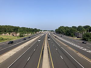
Union is traversed by the Garden State Parkway, Interstate 78, U.S. Route 22 and Route 82 (Morris Avenue).
The Parkway connects Kenilworth in the south to Hillside in the north. The Parkway includes interchanges 139A (Chestnut Street) / 139B (Route 82 West Union), interchanges 140 (Route 22 / Route 82 west) / 140A (Route 22 / Route 82 west) and interchange 141 (Vauxhall Road / Union).
Public transportation
NJ Transit offers rail service at the Union train station providing service on the Raritan Valley Line (formerly the mainline of the Lehigh Valley Railroad) to Newark Penn Station. The station opened in 2003 and includes a parking lot with over 450 spaces.
NJ Transit also provides bus service to New York City and New Jersey points on the 113, 114 and 117 routes to the Port Authority Bus Terminal in Midtown Manhattan, on the 65, 66 70 and 94 routes to Newark and local service on the 26 and 52.
Former Rahway Valley Railroad freight line, now abandoned, crosses through Union. This line, presently leased to Morristown and Erie Railway, is in the process of revitalization after which it will link to NJ Transit's Morris and Essex Lines at Summit and connect to Staten Island.
Newark Liberty International Airport is approximately 6 miles (9.7 km) east of Union.
Notable people
People who were born in, residents of, or otherwise closely associated with Union Township include:
- Aminat Ayinde, the second runner-up from Cycle 12 of America's Next Top Model.
- C. Louis Bassano (born 1942) politician who served in both the New Jersey General Assembly and the New Jersey Senate.
- Isaiah Briscoe (born 1996), basketball player for the Kentucky Wildcats men's basketball team.
- Freddie 'Red' Cochrane (1915–1993), professional boxer in the welterweight (147lb) division who became World Champion in 1941 in that class.
- Joe Collins (1922–1989), first baseman for the New York Yankees from 1948 to 1957. A park on Liberty Avenue is named after him.
- Tom Coyne (1954–2017), mastering engineer.
- Jonathan Townley Crane (1819–1880), clergyman, author and abolitionist.
- Joseph Cryan (born 1961), represents the 20th legislative district in the New Jersey General Assembly.
- Quenton DeCosey (born 1994), professional basketball player for Koroivos of the Greek Basket League.
- Jamie Fox (1954–2017), political strategist.
- Gina Genovese (born 1959), businesswoman and politician who has served as mayor of Long Hill Township.
- Kayla Hoffman (born 1988), artistic gymnast.
- Mildred Barry Hughes (1902–1995), the first woman elected to the New Jersey Senate, in 1965.
- Ron Karkovice (born 1963), Major League baseball catcher from 1986 to 1997.
- Amalya Lyle Kearse (born 1937), a judge of the United States Court of Appeals for the Second Circuit.
- Myra Smith Kearse (1899–1982), physician and community leader.
- Larry Kubin (born 1959), linebacker who played with the Washington Redskins from 1981 to 1984.
- Kelly Kulick (born 1977), professional bowler who became the first woman ever to win a regular Professional Bowlers Association tour title.
- Artie Lange (born 1967), comedian, actor, and former Howard Stern Show sidekick.
- Ray Liotta (born 1954), actor.
- Ed Lucas (1939–2021), blind sportswriter who primarily covered the New York Yankees.
- Elliott Maddox (born 1947), professional baseball player with both the New York Yankees 1974-76 and the New York Mets 1978–80.
- Conde McGinley (born 1890), publisher of the anti-Communist and anti-Semitic weekly paper, Common Sense.
- Bob Mischak (1932 –2014), American football guard and tight end who played in the American Football League and the NFL.
- Eulace Peacock (1914–1996), track and field athlete in the 1930s who was a top competitor of Jesse Owens.
- Matthew John Rinaldo (born 1931), represented New Jersey in the United States House of Representatives for twenty years, in the 12th congressional district (1973–1983) and in the 7th congressional district (1983–1993).
- Tyler Roberson (born 1994), professional basketball player for the Agua Caliente Clippers of the NBA G League.
- Lawrence E. Roberts (1922–2004), pilot with the Tuskegee Airmen and a colonel in the United States Air Force.
- Philip Rubin (born 1949), cognitive scientist, technologist and science administrator.
- Anthony E. Russo (born 1926), former member of the New Jersey Senate who served as Mayor of Union.
- Karl Schellscheidt (born 1968), soccer player, educator and entrepreneur.
- Manfred Schellscheidt (born 1941) German-American soccer coach and former player and member of the National Soccer Hall of Fame.
- Amy Simon (born 1971), planetary scientist at NASA's Goddard Space Flight Center.
- Darnell Stapleton (born 1985), former offensive guard for the Pittsburgh Steelers who was a member of the Steelers' Super Bowl XLIII championship team.
- Travis Taylor (born 1990), professional basketball player.
- Bill Wenzel (1918–1987), cartoonist best known for his good girl art.
- Robert Wuhl (born 1951), actor.
- Darren Young (born 1983), professional wrestler formerly signed to WWE where he is one half of The Prime Time Players with Titus O'Neil.
Education
The Union Public School District serves students in pre-kindergarten through twelfth grade. As of the 2018–19 school year, the district, comprised of 10 schools, had an enrollment of 7,219 students and 614.7 classroom teachers (on an FTE basis), for a student–teacher ratio of 11.7:1. The schools in the district (with 2018–19 enrollment data from the National Center for Education Statistics) are Battle Hill Elementary School (391 students; in grades PreK-4), Hannah Caldwell Elementary School (508; PreK-4), Connecticut Farms Elementary School (403; PreK-4), Franklin Elementary School (417; PreK-4), Livingston Elementary School (424; PreK-4), Washington Elementary School (575; PreK-4), Jefferson Elementary School (544; in grade 5), Burnet Middle School (961; 6-8), Kawameeh Middle School (674; 6-8) and Union High School (2,180; 9-12).
Union was threatened with being the first municipality north of the Mason–Dixon line to suffer from penalties as a result of school segregation. The area of Vauxhall was primarily black and the students enrolled at Jefferson Elementary School were disproportionately black, compared to the rest of the township. Union avoided problems by converting Jefferson Elementary into a sixth-grade only school called Central 6 and bused the Jefferson students to all the other elementary schools. It was later renamed Central 5 and is now Jefferson School, which is used as a one-year school for fifth-grade students.
Union is home to several private nursery schools and the Deron School, a private school for learning disabled students ages 5–13. St. Michael's Parish School and Holy Spirit School (founded in 1965) operate under the supervision of the Roman Catholic Archdiocese of Newark.
Kean University, dating back to 1855, serves a total student population of almost 16,000. Called New Jersey State Teachers College when it was located in Newark, the school moved to Union in 1958, was renamed Kean College in 1973 and was granted university status in 1997.
See also
 In Spanish: Municipio de Union (condado de Union, Nueva Jersey) para niños


