Upper Lake, California facts for kids
Quick facts for kids
Upper Lake, California
|
|
|---|---|

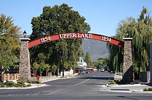
Upper Lake is the gateway to
Mendocino National Forest. |
|

|
|
| Country | United States |
| State | California |
| County | Lake |
| Area | |
| • Total | 1.687 sq mi (4.369 km2) |
| • Land | 1.682 sq mi (4.357 km2) |
| • Water | 0.005 sq mi (0.012 km2) 0.28% |
| Elevation | 1,345 ft (410 m) |
| Population
(2010)
|
|
| • Total | 1,052 |
| • Density | 623.6/sq mi (240.79/km2) |
| Time zone | UTC-8 (Pacific) |
| • Summer (DST) | UTC-7 (PDT) |
| ZIP code |
95485
|
| Area code | 707 |
| FIPS code | 06-81358 |
| GNIS feature IDs | 236896, 2409382 |
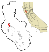
Upper Lake is a census-designated place (CDP) in Lake County, California, United States. Upper Lake is located 8 miles (13 km) north of Lakeport, at an elevation of 1,345 feet (410 m). The population was 1,052 at the 2010 census, up from 989 at the 2000 census. The Habematolel Pomo of Upper Lake are headquartered here.
Contents
History
This community was formerly named Upper Clear Lake and Upperlake.
The settlement began in 1856, when William B. Elliott opened a blacksmith's shop.
The Upper Clear Lake post office opened in 1871, changed its name to Upper Lake in 1875, to Upperlake in 1905, and then back to Upper Lake in 1906.
Geography
According to the United States Census Bureau, the CDP has a total area of 1.7 square miles (4.4 km2), of which over 99% is land.
At the 2000 census, according to the United States Census Bureau, the CDP had a total area of 6.0 square miles (16 km2), of which, 5.8 square miles (15 km2) of it was land and 0.2 square miles (0.52 km2) of it (3.33%) was water.
The Hayville Sulphur Spring, formerly used medicinally, is located 5 miles (8 km) northwest.
Climate
Upper Lake has a Hot-summer Mediterranean climate (Csa) according to the Köppen climate classification system.
| Climate data for Upper Lake (1893-2006) | |||||||||||||
|---|---|---|---|---|---|---|---|---|---|---|---|---|---|
| Month | Jan | Feb | Mar | Apr | May | Jun | Jul | Aug | Sep | Oct | Nov | Dec | Year |
| Record high °F (°C) | 85 (29) |
97 (36) |
90 (32) |
93 (34) |
102 (39) |
109 (43) |
111 (44) |
109 (43) |
110 (43) |
104 (40) |
94 (34) |
80 (27) |
111 (44) |
| Average high °F (°C) | 54.6 (12.6) |
58.3 (14.6) |
62.7 (17.1) |
68.8 (20.4) |
74.7 (23.7) |
84.1 (28.9) |
93 (34) |
92.6 (33.7) |
87.2 (30.7) |
76.7 (24.8) |
64.4 (18.0) |
55.9 (13.3) |
72.8 (22.7) |
| Average low °F (°C) | 32.9 (0.5) |
34.7 (1.5) |
36.6 (2.6) |
39.5 (4.2) |
43.4 (6.3) |
48.3 (9.1) |
52 (11) |
50.2 (10.1) |
45.9 (7.7) |
40.3 (4.6) |
35.6 (2.0) |
32.6 (0.3) |
41 (5) |
| Record low °F (°C) | 9 (−13) |
13 (−11) |
19 (−7) |
24 (−4) |
28 (−2) |
30 (−1) |
32 (0) |
33 (1) |
27 (−3) |
17 (−8) |
16 (−9) |
10 (−12) |
9 (−13) |
| Average precipitation inches (mm) | 7.35 (187) |
5.28 (134) |
4.46 (113) |
2.26 (57) |
1.11 (28) |
0.37 (9.4) |
0.03 (0.76) |
0.07 (1.8) |
0.33 (8.4) |
1.77 (45) |
4.19 (106) |
6.86 (174) |
34.09 (866) |
| Average snowfall inches (cm) | 0.9 (2.3) |
0.3 (0.76) |
0.2 (0.51) |
0 (0) |
0 (0) |
0 (0) |
0 (0) |
0 (0) |
0 (0) |
0 (0) |
0.2 (0.51) |
0.4 (1.0) |
2 (5.1) |
| Average precipitation days | 13 | 10 | 10 | 6 | 4 | 2 | 0 | 0 | 1 | 4 | 8 | 10 | 68 |
| Source: WRCC | |||||||||||||
Demographics
2010
At the 2010 census Upper Lake had a population of 1,052. The population density was 623.6 people per square mile (240.8/km2). The racial makeup of Upper Lake was 842 (80.0%) White, 7 (0.7%) African American, 33 (3.1%) Native American, 7 (0.7%) Asian, 0 (0.0%) Pacific Islander, 104 (9.9%) from other races, and 59 (5.6%) from two or more races. Hispanic or Latino of any race were 242 people (23.0%).
The census reported that 1,043 people (99.1% of the population) lived in households, 9 (0.9%) lived in non-institutionalized group quarters, and no one was institutionalized.
There were 390 households, 142 (36.4%) had children under the age of 18 living in them, 172 (44.1%) were opposite-sex married couples living together, 54 (13.8%) had a female householder with no husband present, 34 (8.7%) had a male householder with no wife present. There were 47 (12.1%) unmarried opposite-sex partnerships, and 3 (0.8%) same-sex married couples or partnerships. 100 households (25.6%) were one person and 44 (11.3%) had someone living alone who was 65 or older. The average household size was 2.67. There were 260 families (66.7% of households); the average family size was 3.18.
The age distribution was 280 people (26.6%) under the age of 18, 96 people (9.1%) aged 18 to 24, 252 people (24.0%) aged 25 to 44, 286 people (27.2%) aged 45 to 64, and 138 people (13.1%) who were 65 or older. The median age was 36.3 years. For every 100 females, there were 91.3 males. For every 100 females age 18 and over, there were 84.7 males.
There were 440 housing units at an average density of 260.8 per square mile, of the occupied units 267 (68.5%) were owner-occupied and 123 (31.5%) were rented. The homeowner vacancy rate was 3.2%; the rental vacancy rate was 6.8%. 683 people (64.9% of the population) lived in owner-occupied housing units and 360 people (34.2%) lived in rental housing units.
2000
At the 2000 census there were 989 people, 389 households, and 259 families in the CDP. The population density was 170.7 people per square mile (66.0/km2). There were 433 housing units at an average density of 74.7 per square mile (28.9/km2). The racial makeup of the CDP was 84.23% White, 0.81% African American, 4.35% Native American, 1.72% Asian, 6.07% from other races, and 2.83% from two or more races. Hispanic or Latino of any race were 14.86%.
Of the 389 households 28.8% had children under the age of 18 living with them, 46.5% were married couples living together, 13.6% had a female householder with no husband present, and 33.4% were non-families. 27.8% of households were composed of one person and 15.4% were composed of one person aged 65 or older. The average household size was 2.50 and the average family size was 3.05.
The age distribution was 26.5% under the age of 18, 10.3% from 18 to 24, 23.3% from 25 to 44, 22.3% from 45 to 64, and 17.6% 65 or older. The median age was 38 years. For every 100 females, there were 92.0 males. For every 100 females age 18 and over, there were 84.5 males.
The median household income was $22,143 and the median family income was $33,393. Males had a median income of $21,964 versus $17,188 for females. The per capita income for the CDP was $11,670. About 23.8% of families and 25.5% of the population were below the poverty line, including 23.7% of those under age 18 and 17.2% of those age 65 or over.
Economy
The early economy of Upper Lake comprised canning beans, growing alfalfa and raising cattle.
Canned beans
During the late 19th century, canned beans developed into the primary economy for Upper Lake in the mid-20th century. The first cannery, which employed 400 people annually, was built in 1897 by A. Mendenhall.
The first cannery was actually built by Mr. Henry Van Wambold. He built his "Blue Lakes Cannery" in 1895 and Mr. Mendenhall followed with his "Clear Lake Cannery" in 1897. This information is found in the State of California archives which show the application paperwork along with the trademark labels that were issued by California for each of these canneries. The name "Blue Lake" green bean was developed near the shores of the Blue Lakes of Lake County, near Upper Lake. Both these canneries were bought out in 1927 and were then renamed the "Lake County Cannery". The Lake County Cannery continued in operation until 1968.
Education
One of the first schools in Lake County was located in Upper Lake. The first teacher was J.W. Mackall, a former cashier at Farmers' Savings Bank.
Notable people
Benjamin Dewell, a member of the Bear Flag Rebellion, settled in Upper Lake, becoming the first permanent white settler, along with his wife Celia, in 1854.
See also
 In Spanish: Upper Lake para niños

