
Urangan, Queensland facts for kids
Quick facts for kids UranganHervey Bay, Queensland |
|||||||||||||||
|---|---|---|---|---|---|---|---|---|---|---|---|---|---|---|---|

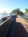
The Esplanade, Urangan
|
|||||||||||||||

Urangan
Location in Queensland
|
|||||||||||||||
| Population | 9,764 (2016 census) | ||||||||||||||
| • Density | 551.6/km2 (1,429/sq mi) | ||||||||||||||
| Postcode(s) | 4655 | ||||||||||||||
| Area | 17.7 km2 (6.8 sq mi) | ||||||||||||||
| Time zone | AEST (UTC+10:00) | ||||||||||||||
| LGA(s) | Fraser Coast Region | ||||||||||||||
| State electorate(s) | Hervey Bay | ||||||||||||||
| Federal Division(s) | Hinkler | ||||||||||||||
|
|||||||||||||||
Urangan is a coastal suburb of Hervey Bay in the Fraser Coast Region, Queensland, Australia. In the 2016 census Urangan had a population of 9,764 people.
Heritage listings
Urangan has a number of heritage-listed sites, including:
- Miller Street: Urangan Point State School, Block D
Education
Urangan Point State School is a government primary (Prep-6) school for boys and girls at Miller Street (25°17′28″S 152°54′07″E / 25.2911°S 152.9020°E). In 2018, the school had an enrolment of 400 students with 36 teachers (30 full-time equivalent) and 24 non-teaching staff (14 full-time equivalent). It includes a special education program.
Sandy Strait State School is a government primary (Prep-6) school for boys and girls at Robert Street (25°18′01″S 152°52′31″E / 25.3004°S 152.8753°E). In 2018, the school had an enrolment of 713 students with 49 teachers (46 full-time equivalent) and 37 non-teaching staff (22 full-time equivalent). It includes a special education program.
Urangan State High School is a government secondary (7-12) school for boys and girls at Robert Street (25°17′48″S 152°52′34″E / 25.2966°S 152.8760°E). In 2018, the school had an enrolment of 1712 students with 146 teachers (139 full-time equivalent) and 66 non-teaching staff (50 full-time equivalent). It includes a special education program.
Images for kids
-
Urangan Seawall & Pier in the background

