
Uvas Canyon County Park facts for kids
Quick facts for kids Uvas Canyon County Park |
|
|---|---|

Swanson Creek in Uvas Canyon
|
|
| Lua error in Module:Location_map at line 420: attempt to index field 'wikibase' (a nil value). | |
| Type | County park |
| Location | 8515 Croy Rd Morgan Hill, CA 95037 |
| Area | 1.79 sq mi (4.6 km2) |
| Operated by | Santa Clara County Parks |
| Status | Open daily |
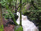
Uvas Canyon County Park is a 1,147-acre (464 ha) natural park located in upper Uvas Canyon on the eastern side of the Santa Cruz Mountains, west of Morgan Hill, California. The park has several small waterfalls, some of which flow perennially, that feed into tributaries confluent with Uvas Creek. The park is part of the Santa Clara County Parks System, and facilitates picnics, hiking and overnight camping. It is one of the few parks in the area that allows dogs in the campgrounds.
Access to Uvas Canyon County Park is via Croy Road, a two-lane paved secondary road off Uvas Road with no outlet that narrows to a single lane within the small private community of Sveadal, just before the park entrance.
Contents
History
In 2017, heavy rains damaged parts of Croy Road as well as much of the park's trail system. After significant repairs, the park has now been re-opened.
Flora
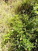
A partial list of trees and plants found in the park is described in the park's Waterfall Loop Nature Trail Guide. Some are non-native species, brought in by early settlers.
- Bigleaf Maple (Acer macrophyllum)
- Blackberry (Rubus ursinus)
- California Buckeye (Aesculus californica)
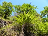
- California Juniper (Juniperus californica)
- California Laurel (Umbellularia californica)
- California Nutmeg (Torreya californica)
- California Sagebrush (Artemisia californica)
- Canyon Live Oak (Quercus chrysolepis)
- Coast Redwood (Sequoia sempervirens)
- Coastal Wood Fern (Dryopteris arguta)
- Coyote Brush (Baccharis spp.)
- Douglas Fir (Pseudotsuga menziesii)
- Golden Back Fern (Pentagramma triangularis)
- Madrone (Arbutus menziesii)
- Miner's Lettuce (Claytonia perfoliata)
- Poison Oak (Toxicodendron diversilobum)
- Sticky Monkey Flower (Diplacus aurantiacus)
- Western Sword Fern (Polystichum munitum)
- Tanbark Oak (Lithocarpus densiflorus)
- Thimbleberry (Rubus parviflorus)
- Tree of Heaven (Ailanthus altissima)
- Western Sycamore (Platanus racemosa)
- White Alder (Alnus rhombifolia)
- Wood Rose (Rosa gymnocarpa)
- Periwinkle (Vinca major)
- Trailing Myrtle (Vinca minor)
- Flora in Uvas Canyon County Park
-
California Buckeye tree in the park. The bark, leaves and fruits of the tree are poisonous to eat. However, its flowers provide nectar to butterflies.
-
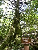
California Juniper tree in the park. Although native to other parts of California, this one was brought in by early settlers.
-
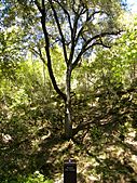
Canyon Live Oak tree in the park. A variety of fauna forage on the tree's acorns and foliage.
-
Sticky monkey flowers in the park. The yellowish flowers are pollinated by hummingbirds and bees.
-
White alder tree overlooking creek in the park. Thick vines of poison oak have grown around the base of the tree.


Fauna
Some animals native to the area include:
- Anna's Hummingbird
- Banana Slug
- Black-tailed Deer
- California Carpenter Bee
- California Newt
- California Quail
- Convergent Lady Beetle
- Coyote
- Mountain Lion
- Red-tailed Hawk
- Steller's Jay
- Santa Cruz Garter Snake
- Tarantula
- Turkey Vulture
- Wild Turkey
- Fauna in Uvas Canyon County Park
-
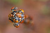
Convergent Lady Beetles near waterfall trail. Lady Bugs gather in the mountain valleys when they enter their overwintering diapause stage.
-
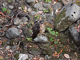
Red-tailed Hawk sitting on the banks of Uvas Creek near Sveadal. The hawks prey on steelhead trout that periodically appear in the creek.
-
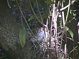
Steller's Jay nesting in a California Bay tree near Sveadal. The birds typically nest in the springtime.
-
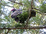
Turkey vulture perched in a Redwood tree near Sveadal. The vulture, along with several others nearby, eye carrion below.


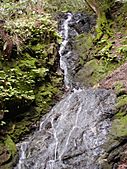
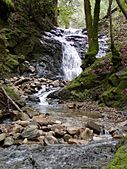
Waterfalls
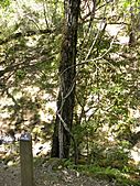
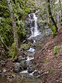
The park has seven small waterfalls, five of which are named on park maps and identified with signposts:
- Basin Falls 37°04′47″N 121°48′22″W / 37.07973°N 121.80613°W
- Black Rock Falls 37°04′57″N 121°48′03″W / 37.08246°N 121.80095°W
- Granuja Falls
- Triple Falls 37°04′41″N 121°47′39″W / 37.07806°N 121.79417°W
- Upper Falls 37°04′47″N 121°48′08″W / 37.07972°N 121.80222°W
The streams are rain and spring fed. Even though the streams are perennial, the best time to visit these waterfalls is after recent rains.
- Waterfalls of Uvas Canyon County Park
-
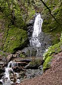
Basin Falls is around 20 feet tall, and is at an elevation of about 1100 ft.
-
Black Rock Falls
-
Granuja Falls
-
Triple Falls is around 35 feet tall.
-
Upper Falls


