
Van, Texas facts for kids
Quick facts for kids
Van, Texas
|
|
|---|---|
.jpg)
Downtown Van, Texas
|
|

Location within Van Zandt County and Texas
|
|
| Country | United States |
| State | Texas |
| County | Van Zandt |
| Area | |
| • Total | 2.99 sq mi (7.75 km2) |
| • Land | 2.99 sq mi (7.75 km2) |
| • Water | 0.00 sq mi (0.00 km2) |
| Elevation | 489 ft (149 m) |
| Population
(2010)
|
|
| • Total | 2,632 |
| • Estimate
(2019)
|
2,741 |
| • Density | 916.42/sq mi (353.86/km2) |
| Time zone | UTC-6 (Central (CST)) |
| • Summer (DST) | UTC-5 (CDT) |
| ZIP code |
75790
|
| Area code(s) | 430, 903 |
| FIPS code | 48-74912 |
| GNIS feature ID | 1376568 |
Van is a city located in southeastern Van Zandt County, Texas, United States, about 75 miles east of Dallas and 26 miles northwest of Tyler. Its population was 2,632 at the 2010 census. The town draws its name from an early settler and school teacher Henry Vance.
Contents
History
Van's first settlers in the area had arrived by the time of the Civil War. By 1874, the town was named Swindall for George Swindall, who donated land for a school west of the present business district and land north of that site in 1891 to the Methodist Church. In 1894 schoolteacher Henry Vance, the town's namesake, established a post office, and the name Van was chosen when the post office renamed the community. A Pure Oil company survey near the town in 1927 led to the discovery of oil at the property on October 13, 1929. Consequently, Van experienced an overnight boom, growing from a rural farming community with a school, and post office to an oil boomtown where thirty buildings, including hotels and stores, had been constructed in only ten days. That November Sun Oil, Shell Petroleum, the Texas Company, Pure Oil, and Humble became co-owners of the field, with Pure Oil as chief operator, and in 1930 the Texas Short Line Railway was extended from Grand Saline. The population numbered 894 throughout the 1930s. The population declined to 620 during World War II, as workers moved away to jobs in war-related industry, but increased steadily thereafter. Businesses in the community fluctuated from a high of fifty in 1934 to a low of fifteen in 1945, but remained between thirty and forty throughout most of the town's history. Mechanization of the oilfield occurred in the 1940s, and by the 1950s Van had a Humble Oil refinery, five churches, and a consolidated independent school district. A total of 591 wells made up the Van field when Pure Oil became a division of Union Oil in 1965. The population of Van grew from 1,103 in 1962 to 1,820 by 1974. The population reached just over 2,600 residents in 2013.
Geography
Van is located at 32°31′34″N 95°38′11″W / 32.526029°N 95.636493°W (32.526029, -95.636493). According to the United States Census Bureau, the city has a total area of 3.0 square miles (7.7 km2), all of it land.
Transportation
Van is served by:
- Interstate 20 is south of downtown Van.
- State Highway 110 is designated as Maple Street in the city; it runs southeast toward Tyler and north to Grand Saline.
- Farm to Market Road 16 is designated as Main Street in the city limits; the road runs west to near Canton and east toward Lindale.
- Farm to Market Road 314 is marked as Oak Street; Van is the northern terminus of this road that runs south toward Brownsboro, just west of Tyler.
- Farm to Market Road 1805 runs from Van and connects to FM 1253 into nearby Smith County.
Demographics
| Historical population | |||
|---|---|---|---|
| Census | Pop. | %± | |
| 1950 | 610 | — | |
| 1960 | 1,103 | 80.8% | |
| 1970 | 1,593 | 44.4% | |
| 1980 | 1,881 | 18.1% | |
| 1990 | 1,854 | −1.4% | |
| 2000 | 2,362 | 27.4% | |
| 2010 | 2,632 | 11.4% | |
| 2019 (est.) | 2,741 | 4.1% | |
| U.S. Decennial Census | |||
As of the census of 2000, 2,362 people, 894 households, and 616 families were residing in the city. The population density was 789.6 people/sq mi (305.0/km2). The 999 housing units wereat an average density of 334.0/sq mi (129.0/km2). The racial makeup of the city was 95.85% White, 0.34% African American, 0.30% Native American, 0.34% Asian, 2.12% from other races, and 1.06% from two or more races. Hispanics or Latinos of any race were 7.11% of the population.
Of the 894 households, 33.9% had children under 18 living with them, 56.4% were married couples living together, 10.1% had a female householder with no husband present, and 31.0% were not families. About 26.7% of all households were made up of individuals, and 17.1% had someone living alone who was 65 or older. The average household size was 2.59, and the average family size was 3.14.
In the city, theage distribution was 27.9% under 18, 7.7% from 18 to 24, 26.2% from 25 to 44, 19.5% from 45 to 64, and 18.7% who were 65 or older. The median age was 36 years. For every 100 females, there were 90.5 males. For every 100 females age 18 and over, there were 82.9 males.
The median income for a household in the city was $32,177, and for a family was $38,864. Males had a median income of $34,464 versus $21,087 for females. The per capita income for the city was $16,495. About 11.1% of families and 14.1% of the population were below the poverty line, including 19.7% of those under age 18 and 10.3% of those age 65 or over.
May 2015 Tornado
On May 10, 2015, shortly after sunset, Van was struck by a strong tornado during the May 5–10, 2015 tornado outbreak sequence. According to the National Weather Service and Tornado chasers, a severe thunderstorm spawned a Tornado that touched down in a heavily wooded thicket just south of Van Zandt County Road 4609, just west of the small community of Primrose, 10 miles south of Van. The Tornado path moved in a direct line north, crossing Texas State Highway 64, picking up strength as it crossed the Neches River, and then Interstate 20 just south of the town. The tornado went straight into the heart of Van, causing heavy damage to structures in the town. It destroyed the elementary school in the city that was a historical monument and then moved straight north through residential neighborhoods, destroying homes and causing massive structural damage. The tornado continued in a straight line north towards Grand Saline. The tornado dissipated 3.5 miles north of Van. Numerous homes and mobile homes were damaged or destroyed, and many trees and power lines were downed throughout Van. A nearby metal-frame industrial building was destroyed. A few well-built frame homes in the northern part of town were left with only interior walls standing. An oil pump derrick toppled to the ground, along with a large metal high-tension truss tower. Several barns and outbuildings were destroyed as well. Two people were killed and 47 were injured, prompting local emergency management officials to declare a mass-casualty incident. The following day, the tornado was given a rating of EF3 from the National Weather Service office in Fort Worth.
Gallery
-
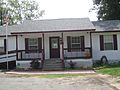
City Hall in Van resembles a residence.
-
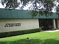
Texas Bank and Trust Co.
-

First United Methodist Church (2012)


Education
Van is served by the Van Independent School District and home to the Van High School Vandals. It is also in the Tyler Junior College taxing district, as many residents attend the school.
Notable people
- Dan Flynn, a businessman and rancher from Van, is a Republican member of the Texas House of Representatives
- Todd Fowler is a former professional football player
See also
 In Spanish: Van (Texas) para niños
