
Van Dyne, Wisconsin facts for kids
Quick facts for kids
Van Dyne, Wisconsin
|
|
|---|---|
|
Census-designated place
|
|

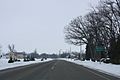
Looking south at downtown Van Dyne
|
|

Van Dyne, Wisconsin
Location in Wisconsin
|
|
| Country | |
| State | |
| County | Fond du Lac |
| Area | |
| • Total | 2.05 km2 (0.790 sq mi) |
| • Land | 2.04 km2 (0.788 sq mi) |
| • Water | 0.005 km2 (0.002 sq mi) |
| Elevation | 241 m (791 ft) |
| Population
(2010)
|
|
| • Total | 279 |
| • Density | 136.4/km2 (353.2/sq mi) |
| Time zone | UTC-6 (Central (CST)) |
| • Summer (DST) | UTC-5 (CDT) |
| Zip codes |
54979
|
| Area code(s) | 920 |
| GNIS feature ID | 1584511 |
Van Dyne is an unincorporated census-designated place in the town of Friendship, in Fond du Lac County, Wisconsin, United States. At the 2010 census, its population is 279. The road traveling north-south through the community was part of the Yellowstone Trail and later Wisconsin Highway 175; it is now a county highway.
History
The community was first platted by Daniel Van Duyne in 1866, and was a stop for a railroad between Fond du Lac and Oshkosh. A post office has been in operation in Van Dyne since 1866.
Images for kids
-
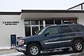
Post office
-
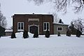
School
-
Sign


See also
 In Spanish: Van Dyne (Wisconsin) para niños

All content from Kiddle encyclopedia articles (including the article images and facts) can be freely used under Attribution-ShareAlike license, unless stated otherwise. Cite this article:
Van Dyne, Wisconsin Facts for Kids. Kiddle Encyclopedia.