
Venice Canal Historic District facts for kids
|
Venice Canal Historic District
|
|

Venice Canal Historic District
|
|

Location in the Los Angeles metropolitan area

Location in California

Location in the United States
|
|
| Location | Los Angeles, California |
|---|---|
| Built | 1905 |
| Architect | Moses Sherman, Eli Clark |
| NRHP reference No. | 82002193 |
Quick facts for kids Significant dates |
|
| Added to NRHP | August 30, 1982 |

The Venice Canal Historic District is embedded in the residential Venice suburb of Los Angeles, California. The historic district is noteworthy for possessing man-made wetland canals, built in 1905 by developer Abbot Kinney as part of his Venice of America. Kinney sought to recreate the appearance and feel of Venice, Italy, in coastal Los Angeles County. The names of the canals were given by Abbot Kinney as follows: Aldebaren Canal, Altair Canal, Cabrillo Canal, Coral Canal, Grand Canal, Lion Canal and Venus Canal.
Another set of canals were built south of the Venice Canals, originally known as the New Amsterdam Canals by investors and architects, namely Howland, Sherman and Clark, for whom two canals were named. These canals are roughly bounded by Eastern Court on the east, Court A on the south, Strongs Drive on the west, and Court E on the north. There are four east-west canals (Carroll Canal, Linnie Canal, Howland Canal, and Sherman Canal) and two north-south canals (Eastern Canal and Grand Canal). The lit canals with gondoliers and arched bridges drew widespread publicity and helped sell lots in the development.
By the 1920s, with cars quickly gaining popularity, the canals were viewed by many as outdated, and as a result a number of canals were filled in 1929 to make room for paved roads. By 1940 the remaining canals had fallen into disrepair, and the sidewalks were condemned by the city. The district remained in poor condition for more than 40 years; numerous proposals to renovate the canals failed due to lack of funding, environmental concerns, and disputes as to who should bear the financial responsibility. The canals were finally renovated in 1992; they were drained, and new sidewalks and walls were built. The canals re-opened in 1993, and have become a desirable and expensive residential section of the city.
The residential district surrounding the remaining canals was listed on the National Register of Historic Places in 1982. However, in recent years, there has been extensive renovation work on many of the old houses, and many large, modern houses have been built.
The water enters the canals through sea gates in the Marina Del Rey breakwater, and again in Washington Boulevard. They open at low tide to drain most of the water, and at high tide they are closed, trapping the water for about three days, before being refreshed again.
Former canals
Before 1929, the area covered by canals was approximately three to four times as large as today. The entire area between Abbot Kinney, Pacific, and Venice Blvd. were canals. These canals were:
- Coral Canal (now Main St.)
- Cabrillo Canal (now Cabrillo Ave.)
- Venus Canal (now San Juan Ave.)
- Lion Canal (now Windward Ave.)
- Altair Canal (now Altair St.)
- Aldebaren Canal (now Market St.)
- Grand Canal (now Grand Boulevard)
Canal Improvement Project
The existing canals were not part of the original Venice Canals built by Abbott Kinney.
They were saved by the mere fact that they did not have a large enough tax base and resident improvements on the lots. At the time the Canals were being filled to make vehicle streets, Los Angeles was in a recession, and couldn't assess the existing canal property owners to pay for the removal and filling in of the canals.
Throughout history, there were several attempts to rehabilitate, restore or improve the canals. However, in every case, the projects were met with fierce opposition and those plans all were stopped or died. One Plan, the Deep water plan, received City of Los Angeles Approval, assessments were sent to the property owners, and Mayor Bradley did a news photo with local residents of the first shovel. But a lawsuit and opposition stopped the project. This project was to include access by large boats from Marina Del Rey into the Venice Canals.
In 1983 Ruth Galanter was elected to the City Council office and inherited a neighborhood sponsored assessment for improving the Venice Canals. The original assessment project was sponsored by the Venice Canals Association(VCA) in 1977 during Pat Russel's term as City Councilperson. The first attempted design was done by City of Los Angeles Engineer Luis Ganajas. The design was known as the vertical wall plan, similar to the Marina Del Rey walls. At the time there were at least 3 attempts through history to restore or rehabilitate the Venice Canals, all leading to failure or opposition. The last attempt was a deep water plan that was stopped in the 1960s. Ruth Galanter was not happy with the environmental aspects, the costs, the Historical design and the safety of the Vertical wall plan, so one of her early actions was to stop the city engineers from pursuing such a plan. Galanter asked the Coastal Conservancy to review the options for the canals, and the state agency returned several plans suggestions, including one using Armorflex. The majority of the neighbors who would be assessed by the new design were opposed to the Armorflex plan. Ruth told the head of the VCA, Mark Galanty, that she would be open to another plan if we found it, but the Armorflex plan was the current city direction. So Mark assembled a committee of the VCA to locate a compromise design and material. Loffelstein, or Loffel Block was identified by a VCA site committee member Andy Shores as possibly meeting those goals. It allowed plants to grow inside the material, could be placed on a slope to allow birds and wildlife to climb out of the canals, was safe for small children as it allowed them to hold on to the sides, and or climb out of the Canals, and was lower cost than the Armorflex. Ruth agreed, and instructed the City Engineers to design a plan using the Loffel Block. Councilwoman Galanter, and staff member Jim Bichart, as well as City Engineers Luis Ganajas, environmental engineer Russ Ruffing worked on the City, State and National approvals. At the Coastal Commission hearing the Venice Canals Association supported the plan, and there was finally no opposition to the restoring of the Venice Canals. The estimated costs for the improvements were 6 million dollars, and included dredging the canals and removing the soil to a class 1 toxic site, removing crumbling sidewalks, replacing new sidewalks, 5 feet deep in center, 1 1/2 feet on the sides, Loffel black at 55 degrees through the canals. Rebuilding the foot bridges that go over the canals. The property owners in the canals paid approximately $6,600 over a 10 year-period for a 30 by 90 foot lot frontage, and $7,800 for a 40 by 90 foot lot frontage. Work began in March 1992, and was completed in 1993. The assessment could be paid in full, or paid over time with interest at approximately 5%.[31]
In addition, the traffic circle at Pacific and Windward Avenues is located on top of what once was the Venice Lagoon.

Images for kids
-
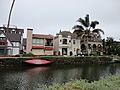
Bungalows on the Venice Canals 2011
-
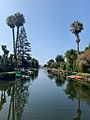
Venice Canals 2019

