
Ventura, California facts for kids
Quick facts for kids
Ventura
San Buenaventura
|
||
|---|---|---|
| City of San Buenaventura | ||
.jpg) .jpg) .jpg) .jpg) Clockwise: Mission San Buenaventura from the Plaza Figueroa; Elizabeth Bard Memorial Hospital; view of the city from Ventura Pier; Father Serra statue in front of Ventura City Hall
|
||
|
||
_Highlighted.svg)
Location in Ventura County
|
||

Ventura
Location in southern California

Ventura
Location in California

Ventura
Location in the United States
|
||
| Country | United States | |
| State | California | |
| County | Ventura | |
| Mission | March 31, 1782 | |
| Incorporated | April 2, 1866 | |
| Named for | Saint Bonaventure | |
| Area | ||
| • Total | 32.29 sq mi (83.63 km2) | |
| • Land | 21.89 sq mi (56.68 km2) | |
| • Water | 10.41 sq mi (26.95 km2) 32.53% | |
| Elevation | 36 ft (11 m) | |
| Population
(2020)
|
||
| • Total | 110,763 | |
| • Rank | 4th in Ventura County 60th in California |
|
| • Density | 3,430.3/sq mi (1,324.44/km2) | |
| Demonym(s) | Venturan | |
| Time zone | UTC−8 (Pacific) | |
| • Summer (DST) | UTC−7 (PDT) | |
| ZIP codes |
93001–93007, 93009
|
|
| Area code(s) | 805 | |
| FIPS code | 06-65042 | |
| GNIS feature IDs | 1667934, 2411779 | |

Ventura, formally known as San Buenaventura (Spanish for "St. Bonaventure"), is a city on the Central Coast of California and the county seat of Ventura County. The population was 110,763 at the 2020 census. Ventura is a popular tourist destination, owing to its historic landmarks, beaches, and resorts.
Ventura was founded by the Spanish in 1782, when Saint Junípero Serra established Mission San Buenaventura. Following the Mexican secularization of the Californian missions, San Buenaventura was granted by Governor Pío Pico to Don José de Arnaz as Rancho Ex-Mission San Buenaventura and a small community arose. Following the American Conquest of California, San Buenaventura eventually incorporated as a city in 1866. The 1920's brought a major oil boom, which along with the post–World War II economic expansion, significantly developed and expanded Ventura.
Contents
History


Prehistory and indigenous peoples
Archaeological discoveries in the area suggest that humans have populated the region for at least 10,000-12,000 years. Archaeological research demonstrates that the Chumash people have deep roots in central and southern coastal regions of California, and has revealed artifacts from their culture. Shisholop Village, designated Historic Point of Interest #18 by the city at the foot of nearby Figueroa Street, was the site of a Chumash village. The Ventura band (Mitskanaka), which was in residence at the time of the arrival of the Spanish, had contact with the Limu band on Santa Cruz Island, who traveled in seagoing Tomols, plank-built boats, bringing shell bead money and chert in trade.
Spanish period (1769 - 1822)
In 1769, the Spanish Portola expedition, first recorded European visitors to inland areas of California, came down the Santa Clara River Valley from the previous night's encampment near today's Saticoy and camped near the outlet of the Ventura River on August 14. Fray Juan Crespi, a Franciscan missionary traveling with the expedition, noted that "we saw a regular town, the most populous and best laid-out of all that we had seen on the journey up to the present time." Archaeological records found that the Chumash village they encountered was settled sometime around 1000 A.D.
Junípero Serra, first leader of the Franciscans in California, founded Mission San Buenaventura in 1782 as his ninth and last mission establish as part of Spain's colonization of Alta California. The mission was named for St. Bonaventure, a Thirteenth Century Franciscan saint and a Doctor of the Church. San Miguel Chapel was the first outpost and center of operations while the first Mission San Buenaventura was being constructed. The first mission burned in 1801 and a replacement building of brick and stone was completed in 1809. The bell tower and facade of the new mission was destroyed by an 1812 earthquake. The Mission was rebuilt and functions as a parish church. Historic tours of downtown include the mission compound.
Mexican period (1822 - 1848)
On July 6, 1841, Governor Juan Bautista Alvarado granted Rancho San Miguel to Felipe Lorenzana and Raymundo Olivas,. Fernando Tico also received a Mexican land grant for part of Ventura. He received a land grant for Ojai and the downtown area of Ventura. whose Olivas Adobe on the banks of the Santa Clara River was the most magnificent hacienda south of Monterey.
Early agricultural development (1848 - 1919)
California became a territory of the United States in 1848 and the 31st state in the Union in 1850. After the American Civil War, settlers came to the area, buying land from the Mexicans, or simply as squatters. Vast holdings were later acquired by Easterners, including the railroad magnate, Thomas A. Scott. He was impressed by one of the young employees, Thomas R. Bard, who had been in charge of train supplies to Union troops, and Bard was sent west to handle Scott's property. Not easily accessible, Ventura was not a target of immigrants, and remained quiet and rural. For most of the century which followed the incorporation of Ventura in 1866, it remained isolated from the rest of the state.
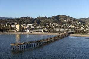
Ventura Pier was built in 1872 at a cost of $45,000 and was the longest wooden Pier in California. In 1914 a ship shattered the pier. It was rebuilt to a length of 1,700 feet (520 m) by 1917. An active wharf for 64 years, it was reinforced with steel pilings after 420 feet (130 m) of the pier was destroyed by a storm in 1995.
Oil and development boom (1920 - 1945)
Bard is often regarded as the Father of Ventura County and his descendants have been prominently identified with the growth of the county. The Union Oil Company was organized with Bard as President in 1890, and has offices in Santa Paula. The large Ventura Oil Field was first drilled in 1919 and at its peak produced 90,000 barrels per day (14,000 m3/d). The development of the oil fields in the 1920s, along with the building of better roads to Los Angeles and the affordability of automobiles, enabled a major real estate boom. Contemporary downtown Ventura is defined by extant buildings from this period. In this bustling oil boom town Ventura Theatre opened in 1928. During this decade, many other buildings were constructed: the Hobson Brothers Meat Packing Company (1923), the First National Bank of Ventura (1926) (commonly called the Earl Stanley Gardner), the Ventura Hotel (1926), the Elks Lodge - B. P. 0. E. #1430 (1928), the Mission Theater (1928), the Hotel Washington (1928), the Swift & Company Building (1928), and the Masonic Temple (1929).
Located between the Ventura River and the Santa Clara River, the soil is so fertile that town boosters claimed that citrus grew better here than anywhere else in the state. The citrus farmers formed Sunkist Growers, Incorporated, the world's largest organization of citrus production. On March 12, 1928, the St. Francis Dam, 54 mi (87 km) inland, failed catastrophically, taking over 600 lives. The resulting flood reached Montalvo about 5:30 a.m., almost two miles (3 km) wide and traveling at a speed of 5 mph (8.0 km/h) per hour.
Postwar years and the 1950s boom (1946 - present)

From the south, travel by auto was slow and hazardous, until the completion of a four-lane freeway (US Highway 101) over the Conejo Grade in 1959. This route, now further widened and improved by 1969, is known as the Ventura Freeway, which directly links Ventura with the rest of the Los Angeles metropolitan area. Another route, US Highway 101 ALT (now the Pacific Coast Highway) traveled along the coast from Santa Monica via Oxnard, but was not heavily used.
From the north, the entrance was by way of a single road along the beach and stagecoach passengers either had to wait until low tide when the horses could cross on the exposed wet sand, or go up the Ventura River Valley and then cross over the mountains to Santa Barbara via Casitas Pass, a long and difficult trip. In 1913, the Rincon Sea Level Road and the Ventura River Bridge opened; motoring tourists no longer had to fear coming through here.
Inland, Ventura was hemmed in by the mountainous country and deep canyons of the Los Padres National Forest. This route became passable with the completion of the Maricopa Highway (U.S. 399, now state highway 33) in the 1930s, connecting Ventura and Ojai with the San Joaquin Valley.
Ventura continued to grow steadily. In 1920 there were 4,156 people. In 1930 the population had increased to 11,603, by 1950 the population reached 16,643, by 1970 the population was 57,964, and in 1980 the population had increased to 73,774. In the last three decades it has increased to approximately 107,000. To minimize outward growth onto the agricultural land that surrounds the existing community, the city is pursuing a strategy of "in-fill first" with the 2005 General Plan which means growth will focus inward to certain "Districts, Corridors, and Neighborhood Centers" that will become more intensely populated.
Geography

Ventura is located northwest of Los Angeles on the California coast. The western portion of the City stretches north along the Ventura River and is characterized by a narrow valley with steeply sloped areas along both sides. The steep slopes of the Ventura foothills abut the northern portion of the community. Much of the eastern portion is on relatively flat alluvial coastal plain lying along the western edge of the Oxnard Plain. The Santa Clara River forms the city's southerly boundary with the city limits reaching up to the beginning of the Santa Clara River Valley at the historic community of Saticoy.
According to the United States Census Bureau, Ventura has a total area of 32.1 square miles (83 km2), of which 21.7 square miles (56 km2) is land and 10.4 square miles (27 km2) (32.53%) is water.
Climate
Ventura has a Mediterranean climate, typical of most coastal California cities, with the sea breeze off the Pacific Ocean moderating temperatures. It is not uncommon for the city to be affected by Santa Ana winds off the Transverse Ranges on occasion, which increase temperatures dramatically.
| Climate data for Ventura, California | |||||||||||||
|---|---|---|---|---|---|---|---|---|---|---|---|---|---|
| Month | Jan | Feb | Mar | Apr | May | Jun | Jul | Aug | Sep | Oct | Nov | Dec | Year |
| Record high °F (°C) | 88 (31) |
91 (33) |
99 (37) |
100 (38) |
101 (38) |
102 (39) |
103 (39) |
103 (39) |
103 (39) |
103 (39) |
99 (37) |
96 (36) |
103 (39) |
| Average high °F (°C) | 66 (19) |
66 (19) |
65 (18) |
68 (20) |
68 (20) |
70 (21) |
73 (23) |
74 (23) |
74 (23) |
73 (23) |
70 (21) |
66 (19) |
69 (21) |
| Daily mean °F (°C) | 55.5 (13.1) |
56.5 (13.6) |
56.5 (13.6) |
59 (15) |
60.5 (15.8) |
63 (17) |
66 (19) |
67 (19) |
66.5 (19.2) |
64 (18) |
59.5 (15.3) |
55.5 (13.1) |
60.8 (16.0) |
| Average low °F (°C) | 45 (7) |
47 (8) |
48 (9) |
50 (10) |
53 (12) |
56 (13) |
59 (15) |
60 (16) |
59 (15) |
55 (13) |
49 (9) |
45 (7) |
52 (11) |
| Record low °F (°C) | 29 (−2) |
28 (−2) |
31 (−1) |
35 (2) |
39 (4) |
42 (6) |
44 (7) |
46 (8) |
42 (6) |
37 (3) |
33 (1) |
29 (−2) |
28 (−2) |
| Average rainfall inches (mm) | 3.41 (87) |
3.90 (99) |
3.04 (77) |
0.72 (18) |
0.21 (5.3) |
0.05 (1.3) |
0.02 (0.51) |
0.07 (1.8) |
0.36 (9.1) |
0.36 (9.1) |
1.37 (35) |
2.11 (54) |
15.62 (397) |
| Source: http://www.weather.com/outlook/travel/businesstraveler/wxclimatology/monthly/graph/USCA1193 | |||||||||||||
Demographics
| Historical population | |||
|---|---|---|---|
| Census | Pop. | %± | |
| 1880 | 1,370 | — | |
| 1890 | 2,320 | 69.3% | |
| 1900 | 2,470 | 6.5% | |
| 1910 | 2,901 | 17.4% | |
| 1920 | 4,156 | 43.3% | |
| 1930 | 11,603 | 179.2% | |
| 1940 | 13,264 | 14.3% | |
| 1950 | 16,534 | 24.7% | |
| 1960 | 29,114 | 76.1% | |
| 1970 | 57,964 | 99.1% | |
| 1980 | 73,774 | 27.3% | |
| 1990 | 92,575 | 25.5% | |
| 2000 | 100,916 | 9.0% | |
| 2010 | 106,433 | 5.5% | |
| 2020 | 110,763 | 4.1% | |
| U.S. Decennial Census | |||


2010
The 2010 United States Census reported that Ventura had a population of 106,433. The population density was 3,316.2 people per square mile (1,280.4/km2). The racial makeup of Ventura was 76.6% White, 1.6% African American, 1.2% Native American, 3.4% Asian (0.9% Filipino, 0.6% Chinese, 0.4% Indian, 0.4% Korean, 0.4% Japanese, 0.3% Vietnamese, 0.5% Other), 0.2% Pacific Islander, 5.2% from two or more races. Hispanic or Latino of any race were 31.8% of the population.
The Census reported that 103,940 people (97.7% of the population) lived in households, 755 (0.7%) lived in non-institutionalized group quarters, and 1,738 (1.6%) were institutionalized.
There were 40,438 households, out of which 13,014 (32.2%) had children under the age of 18 living in them, 18,907 (46.8%) were opposite-sex married couples living together, 4,936 (12.2%) had a female householder with no husband present, 2,153 (5.3%) had a male householder with no wife present. There were 2,621 (6.5%) unmarried opposite-sex partnerships, and 371 (0.9%) same-sex married couples or partnerships. 10,959 households (27.1%) were made up of individuals, and 4,271 (10.6%) had someone living alone who was 65 years of age or older. The average household size was 2.57. There were 25,996 families (64.3% of all households); the average family size was 3.14.
The population was spread out, with 23,918 people (22.5%) under the age of 18, 9,581 people (9.0%) aged 18 to 24, 28,814 people (27.1%) aged 25 to 44, 29,957 people (28.1%) aged 45 to 64, and 14,163 people (13.3%) who were 65 years of age or older. The median age was 39.0 years. For every 100 females, there were 97.7 males. For every 100 females age 18 and over, there were 95.6 males.
There were 42,827 housing units at an average density of 1,334.4 per square mile (515.2/km2), of which 22,600 (55.9%) were owner-occupied, and 17,838 (44.1%) were occupied by renters. The homeowner vacancy rate was 1.3%; the rental vacancy rate was 5.5%. 59,330 people (55.7% of the population) lived in owner-occupied housing units and 44,610 people (41.9%) lived in rental housing units.
2000
.jpg)
As of the census of 2000, there were 100,916 people, 38,524 households, and 25,233 families residing in the city. The population density was 4,790.6 inhabitants per square mile (1,849.3/km2). There were 39,803 housing units at an average density of 1,889.5 per square mile (729.4/km2). The racial makeup of the city was 78.8% White, 1.4% African American, 1.2% Native American, 3.0% Asian, 0.2% Pacific Islander, 11.1% from other races, and 4.3% from two or more races. Hispanic or Latino of any race were 30.4% of the population.
There were 38,524 households, out of which 32.1% had children under the age of 18 living with them, 49.2% were married couples living together, 11.7% had a female householder with no husband present, and 34.5% were non-families. 26.5% of all households were made up of individuals, and 9.7% had someone living alone who was 65 years of age or older. The average household size was 2.56 and the average family size was 3.12.
In the city, the population was spread out, with 25.0% under the age of 18, 7.8% from 18 to 24, 31.5% from 25 to 44, 22.8% from 45 to 64, and 12.8% who were 65 years of age or older. The median age was 37 years. For every 100 females, there were 96.9 males. For every 100 females age 18 and over, there were 93.8 males.
The median income for a household in the city was $52,297, and the other income for a family was $60,466. Males had a median income of $43,828 versus $31,793 for females. The per capita income for the city was $25,065. About 6.4% of families and 9.0% of the population were below the poverty line, including 12.2% of those under age 18 and 5.3% of those age 65 or over.
Arts and culture
The Ventura County Fairgrounds is the home of the annual Ventura County Fair, and over the years has hosted such acts as Jimi Hendrix, The Grateful Dead, Smokey Robinson, and All American Rejects, as well as the Vans Warped Tour. The Derby Club (offering Horse Racing Live via Satellite), and full service bars and restaurants. The Train Station for Amtrak's Pacific Surfliner route is adjacent to the fairgrounds.
The Ventura Film Festival puts on a yearly red carpet gala event and has hosted some of film's top celebrities including the 50th Anniversary of the famous film "West Side Story (film)" and given awards to the Academy Award-winning cast of "West Side Story" and a lifetime achievement award to Academy Award winner George Chakiris and Academy Award Nominee Russ Tamblyn. The films Swordfish, Little Miss Sunshine, Chinatown, Erin Brockovich, The Aviator, and The Rock were partly filmed in Ventura, and most of the 2011 release Bellflower was shot in Ventura. Ancestors of land grant recipient Fernando Tico have been heavily involved in the Arts. Randy Tico was the music coordinator for a Bo Derick movie with Anthony Quinn and Donald Trump. Nate Tico is a talent scout focussing on voice overs and Edward Tico is a television producer for KMVT15.
Downtown's Majestic Ventura Theater is an early 20th-century landmark. A venue for concerts, it has seen performances from legendary artists such as The Doors, Pearl Jam, Van Halen, X, Ray Charles, Red Hot Chili Peppers, Social Distortion, Bad Religion, Fugazi, Incubus, Tom Petty, They Might Be Giants, and Johnny Cash, as well as some of the city's most successful homegrown artists like Big Bad Voodoo Daddy and Army of Freshmen.
In popular culture
Film
The movies Swordfish and Little Miss Sunshine were partially filmed in Ventura, as were parts of the movie Erin Brockovich.
The comedy film, The Bet, was filmed entirely in the city of Ventura and was written by Ventura residents, Chris Jay and Aaron Goldberg, both members of the band Army of Freshmen.
Books
Ventura was fictionalized as 'Madison City' by long-time resident Erle Stanley Gardner in his D.A. Series of crime novels featuring Doug Selby, crusading District Attorney of a rural California county.
Points of interest

Downtown Ventura
Downtown Ventura is home to the Mission San Buenaventura, museums, galleries, dining, and shopping. Primary areas of activity include California Street and Main Street between Ventura Avenue and Fir Street. Located in downtown is the historic Ortega Adobe, once home to the Ortega family, now famous for their chili products. Numerous thrift stores contrast with high-end shops and restaurants. Downtown Ventura is home to Ventura's ornate city hall with its statue of Junipero Serra. Downtown now features numerous restaurants, wine bars and the internationally acclaimed Rubicon Theatre Company.
Ventura Visitors Center
The 4,300-square-foot (400 m2) Ventura Visitors Center, at 101 South California Street, has exhibits on the Heritage Valley, Channel Islands National park, the local arts scene, and maps and brochures about the area.

Two Trees
One of the most recognizable landmarks in Ventura is "Two Trees" which are two prominent lone trees on a hilltop, visible from most of Ventura. Access to the hill is private property. Signs at the bottom of the trails and at the trees themselves warn trespassers.
Plaza Park
In Plaza Park (Chestnut and Santa Clara Streets, downtown) stands one of the nation's largest Moreton Bay Fig Trees. Across the street, the main post office has murals on interior walls commissioned by the Section of Painting and Sculpture of the U.S. Treasury Department as New Deal art.
Ventura Harbor
The Ventura Harbor has fishing boats, seafood restaurants and a retail center, the Ventura Harbor Village. The Channel Islands National Park Headquarters is also located in the harbor, and boats to the Channel Islands depart from there daily.
The Westside of Ventura is a large Subdivision of neighborhoods, along Ventura Avenue.
Pierpont Bay
Pierpont Bay (Pierpont) is a residential neighborhood in the one-mile stretch between the Ventura Harbor and San Buenaventura State Beach. Reclaimed marshland was subdivided in 1925 and houses were built in fits of development interrupted by years of economic depression, war, and coastal floods (in 1937 and 1962). Long a hodge-podge of rental dwellings, weekend cottages and vacant lots, it was transformed by successive California real estate booms into a fashionable but eclectic mix of newer large homes and older modest beach cottages, now mostly owner-occupied. Piecemeal development, not overly burdened by planning efforts or regulatory attentions, left Pierpont with widely varying architectural styles, a spotty retail district on Seaward Avenue, newer residents' demands for increased municipal maintenance, and continuing disputes about the proper regulation of the neighborhood's public beaches. Recently plans have been announced for high-density development on some streets, and state authorities have begun to more actively manage beaches that were mostly self-regulated for eighty years.

Olivas Adobe
The Olivas Adobe, one of the early "California Rancho" styled homes, is operated today as a museum and performing arts venue. Located adjacent to the Olivas Park Golf Course, the home is one of the most visited historic sites on the central Pacific Coast. Living history reenactments, demonstrations of Rancho life, and wonderful ghost stories abound. A summer music series of performances held in the old home's courtyard feature an eclectic assortment of artists from blues to jazz to country.
Erle Stanley Gardner
The famous character, lawyer "Perry Mason", created by Erle Stanley Gardner, first as novels and then later as a television series in the late 1950s and early '60s, followed by several "made-for-TV" movies in the 1980s, had his fictional law practice and did much of his early writing in Downtown Ventura. The building where his law offices were housed, at California and Main Streets, bears his name on a state historical marker.
Notable locations

|
|
Parks

|
|
Sister cities
 Loreto, Baja California Sur (Mexico)
Economy


Ventura is a popular tourist destination in Southern California, owing to its historic landmarks, beaches, and the local leisure economy. Businesses related to tourism and hospitality account for a significant portion of Ventura's economic activity.
The outdoor clothing manufacturer Patagonia is based in Ventura. Diaper bag manufacturer Petunia Pickle Bottom was founded in Ventura. Research and resource company The Barna Group is located near downtown Ventura.
In 2009 the City of Ventura created Ventura Ventures Technology Center, a business incubator with a high-tech focus. Ventura Ventures Technology Center was created as an economic engine to develop jobs and companies locally, as well as attract entrepreneurs to the area. The Trade Desk was started in the incubator.
Top employers
According to the city's 2020 Comprehensive Annual Financial Report, the top employers in the city are:
| # | Employer | Number of Employees | % of Total City Employment |
|---|---|---|---|
| 1 | County of Ventura | 8,232 | 15.08% |
| 2 | Ventura Unified School District | 2,650 | 4.85% |
| 3 | Community Memorial Health System | 2,176 | 3.99% |
| 4 | Employer's Depot Inc. | 820 | 1.50% |
| 5 | Patagonia Works (Lost Arrow Corp.) | 665 | 1.22% |
| 6 | Kaiser Permanente | 656 | 1.20% |
| 7 | Ventura County Community College District | 653 | 1.20% |
| 8 | City of San Buenaventura | 615 | 1.13% |
| 9 | Target | 495 | 0.91% |
| 10 | Ventura Superior Court | 305 | 0.56% |
Education

Ventura has four college campuses: Ventura College of Law, Southern California Institute of Law, Santa Barbara Business College and Ventura College. Ventura College of Law is a non-profit law school founded in 1969. Ventura College is a community college, part of the Ventura County Community College District. The Brooks Institute of Photography shut down in 2016 after many years in the community.
Public school students from kindergarten through 12th grade attend schools in the Ventura Unified School District. The district has five high schools: Ventura High in the midtown area, Buena High in east Ventura, Foothill Technology High School, Pacific High School and El Camino High School, an independent study program located on the Ventura College campus. Private schools include St. Bonaventure High School, a Catholic school, Ventura County Christian School, Ventura Missionary School, evangelical Christian schools, and Holy Cross School, Sacred Heart, and Our Lady of the Assumption, Roman Catholic schools for grades pre-kindergarten through 8.
Infrastructure
.JPG)
Transportation
The major road through Ventura is the Ventura Freeway (U.S. Route 101), connecting the California Central Coast and San Francisco to the north, and Los Angeles to the south. State Route 33, the Ojai Freeway, heads north to Ojai. State Route 126 and State Route 118 head east to Santa Clarita and Simi Valley, respectively.
The East Ventura Station, in the historic Montalvo neighborhood, serves as the western terminus of the Ventura County Line of the Metrolink commuter rail system, which extends to Los Angeles' Union Station. The downtown Ventura Amtrak Station is served by Amtrak's Pacific Surfliner from San Luis Obispo to San Diego.
Local bus service is provided by Gold Coast Transit. Commuter and intercity bus services are provided by VISTA and by MTD to Santa Barbara.
The Downtown - Harbor Trolley began its free service on July 3, 2013. The Trolley makes loops from Downtown to Ventura Harbor.
Utilities

Ventura provides water to its residents and some unincorporated areas near the city. Water sources are Lake Casitas, the Ventura River, and groundwater. The water system includes 3 treatment plants, 10 wells, and 27 reservoirs.
Sanitary sewer services are treated at a single plant in 1955. The plant, within a former portion of the estuary of the Santa Clara River, has ponds of treated water that attract birds. Some recycled water from the plant is used for landscaping and other non potable uses.
The Montalvo Community Services District looked at the cost of a new treatment plant in 2014 and considered having the city take over their service area and dissolve the district. The Montalvo Municipal Improvement District had been formed 60 years prior to bringing sewer service to what was then a remote unincorporated area southeast of Ventura. The city of Ventura annexed the last unincorporated portions of Montalvo in 2012 and had already begun to provide water to the community before the annexation.
Notable people
- Kevin Costner, actor, attended Buena High School.
- Zachary Levi, actor, attended Buena High School.
- Natasha Halevi, actress and director, attended Saint Bonaventure High School. She is married to actor Sean Gunn.
- James Ennis III, basketball player for the Philadelphia 76ers, was born in Ventura.
- Frank Churchill, composer for Disney, began his career in Ventura.
- Theodosia Burr Shepherd (1845–1906) was an American botanist, horticulturist and pioneer in plant breeding. She was called the “Flower Wizard of California”, and "The Pioneer Seed-grower", as she was the first woman in California and possibly in the United States to hybridize flowers. Her seed and bulb business, the Theodosia B. Shepherd Company, is considered to be the foundation of the California seed industry and is listed as number 34 in the City of Ventura Historic Landmarks and Districts. She was compared favorably to Luther Burbank.
- Erle Stanley Gardner (1889–1970) created the fictional lawyer Perry Mason, who appeared first in novels and then later in a television series from 1957 to 1966, followed by several "made-for-TV" movies in the 1980s. Gardner himself was a lawyer and did much of his early writing in Downtown Ventura. The First National Bank building at California and Main streets, where Gardner's law office was located, bears his name on a state historical marker and is also identified as the "Erle Stanley Gardner Building" over the front entrance.
- Cirith Ungol, an influential heavy metal band who formed in Ventura in 1972 and are still active.
Images for kids
-
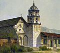
Ventura was founded by the Spanish in 1782, when Saint Junípero Serra established Mission San Buenaventura.
-
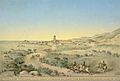
Mission San Buenaventura in 1839.
-
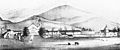
Village of San Buenaventura in 1865.
-
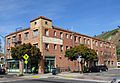
Casa de Anza, built in 1929 to house workers from the Ventura Oil Field.
-
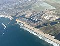
View of Ventura Harbor.
-
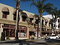
Historic California Churrigueresque architecture in Downtown Ventura.
-
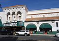
The historic Ventura Theatre was built as a movie palace in 1928.
-
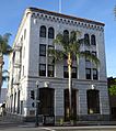
First National Bank of Ventura.
_(cropped).jpg)
_(cropped).jpg)
.jpg)
.jpg)

_(4051708522)_(cropped).jpg)
.jpg)
_(cropped).jpg)
See also
 In Spanish: Ventura (California) para niños
