
Vernor, Queensland facts for kids
Quick facts for kids VernorSomerset Region, Queensland |
|||||||||||||||
|---|---|---|---|---|---|---|---|---|---|---|---|---|---|---|---|

Forest Hill-Fernvale Road, 2014
|
|||||||||||||||

Vernor
Location in Queensland
|
|||||||||||||||
| Population | 233 (2016 census) | ||||||||||||||
| • Density | 25.89/km2 (67.1/sq mi) | ||||||||||||||
| Postcode(s) | 4306 | ||||||||||||||
| Area | 9.0 km2 (3.5 sq mi) | ||||||||||||||
| Time zone | AEST (UTC+10:00) | ||||||||||||||
| Location | |||||||||||||||
| LGA(s) | Somerset Region | ||||||||||||||
| State electorate(s) | Lockyer | ||||||||||||||
| Federal Division(s) | Blair | ||||||||||||||
|
|||||||||||||||
Vernor is a rural locality in the Somerset Region, Queensland, Australia. In the 2016 census, Vernor had a population of 233 people.
Images for kids
-
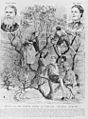
Engraving of the Vernor family rescued during the February flood near Fernvale, 1893


All content from Kiddle encyclopedia articles (including the article images and facts) can be freely used under Attribution-ShareAlike license, unless stated otherwise. Cite this article:
Vernor, Queensland Facts for Kids. Kiddle Encyclopedia.