
Villanueva, New Mexico facts for kids
Quick facts for kids
Villanueva, New Mexico
|
|
|---|---|

Villanueva, New Mexico
Location in New Mexico
|
|
| Country | United States |
| State | New Mexico |
| County | San Miguel |
| Elevation | 5,869 ft (1,789 m) |
| Population
(2010)
|
|
| • Total | 234 |
| Time zone | UTC-7 (MST) |
| • Summer (DST) | UTC-6 (MDT) |
| ZIP code |
87583
|
| Area code | 505 |
| FIPS code | 35-83130 |
| GNIS ID | 915912 |
Villanueva is an unincorporated community and census-designated place in San Miguel County, New Mexico, United States. Known as La Cuesta until 1890, it is located along the Pecos River and New Mexico State Road 3. Villanueva has the ZIP code 87583. The 87583 ZIP Code Tabulation Area had a population of 234 in the 2010 United States census, compared to 267 in 2000. A total of 211 residents of Villanueva in 2010 identified themselves as Hispanic.
Contents
History
Villanueva, an old Spanish colonial village, was originally called La Cuesta (Spanish, hill or slope) because the village sits on top of a steeply sloping hill or cuesta in the Pecos Valley. Soon after the Spanish Government approved the San Miguel del Vado Land Grant in 1794, settlements were established along the banks of the Pecos River, such as Bernal, El Pueblo, Entrnosa, Guzano, La Cuesta, Las Mulas, Puertecito, San Jose, San Miguel.
Some Cibolero buffalo hunters of the 19th century originated from La Cuesta and other Hispano communities along the Pecos River.
In 1890, the community was renamed to Villanueva, for a prominent local family.
Area attractions
East of Villanueva is Villanueva State Park, a colorful canyon cut by the Pecos River.
- The Villanueva, New Mexico story; F. Stanley; 24 pages; 1970.
- 1870 Census of La Cuesta (Villanueva), page 1, page 2
Images for kids
-
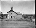
Church at Villanueva, ca. 1915.
-
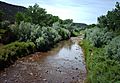
The Pecos River at Villanueva.


See also
 In Spanish: Villanueva (Nuevo México) para niños
