
Waimakariri River facts for kids
Quick facts for kids Waimakariri River |
|
|---|---|

View of the Waimakariri River looking towards the Southern Alps
|
|

Map of the course of the Waimakariri River
|
|
| Country | New Zealand |
| Region | Canterbury |
| Physical characteristics | |
| Main source | Southern Alps, near Mount Rolleston Southern Alps, Canterbury 1,535 m (5,036 ft) 42°54′13″S 171°29′48″E / 42.90361°S 171.49667°E |
| River mouth | Brooklands Lagoon, Pacific Ocean near Kaiapoi 0 m (0 ft) 43°23′26″S 172°42′29″E / 43.39056°S 172.70806°E |
| Length | 151 km (94 mi) |
| Basin features | |
| Tributaries |
|
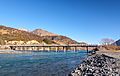
The Waimakariri River is one of the largest rivers in Canterbury, New Zealand. It is on the eastern coast of New Zealand's South Island. It flows for 151 kilometres (94 mi) southeast from the Southern Alps across the Canterbury Plains to the Pacific Ocean.
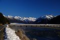
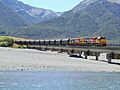
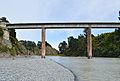
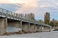
The river is a fine example of a braided river. As the photograph shows, for much of its upper reaches, the river is braided. It runs across wide shingle beds. As the river approaches the Canterbury Plains, it passes through a belt of mountains. There it is forced into a narrow canyon (the Waimakariri Gorge). Then it goes back to its braided form across the plains. It enters the Pacific north of Christchurch, near the town of Kaiapoi.
Most New Zealand river beds are unoccupied crown land, but the bed of the Waimakariri River is looked after by the Canterbury Regional Council (Environment Canterbury).
Images for kids
-
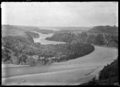
View of river at Kowai Bush near Springfield, 1927
-
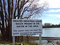
A water pollution sign on the lower reaches of the river
-
-
-
-
-
-
-


See also
 In Spanish: Río Waimakariri para niños
