Walgett, New South Wales facts for kids
Quick facts for kids WalgettNew South Wales |
|||||||||
|---|---|---|---|---|---|---|---|---|---|

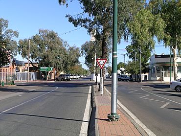
Main street, Walgett (Fox Street/Castlereagh Highway) looking south over Wee Waa Street
|
|||||||||
| Population | 2,145 (2016 census) | ||||||||
| Postcode(s) | 2832 | ||||||||
| Elevation | 133 m (436 ft) | ||||||||
| Location |
|
||||||||
| LGA(s) | Walgett Shire | ||||||||
| County | Baradine | ||||||||
| State electorate(s) | Barwon | ||||||||
| Federal Division(s) | Parkes | ||||||||
|
|||||||||


Walgett is a town in northern New South Wales, Australia, and the seat of Walgett Shire. It is near the junctions of the Barwon and Namoi Rivers and the Kamilaroi and Castlereagh Highways. In 2016, Walgett had a population of 2,145.
In the 2016 Census, there were 6,107 people in the Walgett Local Government Area. Of these 52.9% were male and 47.1% were female. Aboriginal and/or Torres Strait Islander people made up 29.4% of the population. Walgett takes its name from an Aboriginal word meaning 'the meeting place of two rivers'. The town was listed as one of the most socially disadvantaged areas in the State according to the 2015 Dropping Off The Edge report.
History
A post office was gazetted for "Wallgett on the Barwin River" in 1851 and the town sites were surveyed in 1859. The district would have been occupied prior to this by squatters and their livestock. The town of Walgett was proclaimed on 20 March 1885. The surveyor Arthur Dewhurst mapped the town, naming three streets after British Prime Ministers: Fox (main street—Castlereagh Highway), Pitt and Peel. Arthur Street was named after another surveyor. Walgett Courthouse was built in 1865.
Walgett was a port in the late 19th century for paddle steamers that plied the Murray-Darling river system. The first steamer reached Walgett in 1861 and travelled to the town regularly until c.1870.
Euroka Station, 10 miles (16 km) south of the town on the Castlereagh Highway, was purchased by Fred Wolseley in 1876 and was the site of the invention of the Wolseley Shearing Machine. The machine was tested at Bourke in 1888 on 184,000 sheep and eventually revolutionised the shearing industry.
Walgett's history includes the Freedom Rides in the mid-1960s. After their protests the Freedom Riders left town and headed for Narrabri, when a short distance from town their bus was forced off the road by a car driven by a local farmer. This event led to Walgett, the Freedom Riders and the plight of Indigenous Australians receiving national and international media attention.
Climate
Walgett's climate is hot to very hot in summer and mild to cool in winter, with occasional frosts. Summer temperatures frequently rise above 40 °C, and a maximum temperature of 49.2 °C (120.6 °F) was recorded on 3 January 1903, which is one of the hottest temperatures recorded in the state. The annual rainfall is fairly low, at 479.8 mm (18.8 in) which falls fairly evenly throughout the year; however, summer rainfall usually falls as heavy but infrequent downpours associated with thunderstorms; winter rain is usually very light, but can last for days at a time.
| Climate data for Walgett (1878-2012) | |||||||||||||
|---|---|---|---|---|---|---|---|---|---|---|---|---|---|
| Month | Jan | Feb | Mar | Apr | May | Jun | Jul | Aug | Sep | Oct | Nov | Dec | Year |
| Record high °C (°F) | 49.2 (120.6) |
46.9 (116.4) |
43.1 (109.6) |
37.8 (100.0) |
32.9 (91.2) |
29.4 (84.9) |
28.9 (84.0) |
34.4 (93.9) |
38.9 (102.0) |
42.6 (108.7) |
45.6 (114.1) |
47.8 (118.0) |
49.2 (120.6) |
| Average high °C (°F) | 35.4 (95.7) |
34.0 (93.2) |
31.4 (88.5) |
26.8 (80.2) |
21.8 (71.2) |
18.0 (64.4) |
17.4 (63.3) |
19.8 (67.6) |
23.8 (74.8) |
28.1 (82.6) |
31.9 (89.4) |
34.6 (94.3) |
26.9 (80.4) |
| Average low °C (°F) | 20.4 (68.7) |
19.9 (67.8) |
17.1 (62.8) |
12.5 (54.5) |
8.2 (46.8) |
5.5 (41.9) |
4.2 (39.6) |
5.5 (41.9) |
8.6 (47.5) |
12.8 (55.0) |
16.3 (61.3) |
18.9 (66.0) |
12.5 (54.5) |
| Record low °C (°F) | 5.0 (41.0) |
9.4 (48.9) |
2.8 (37.0) |
0.6 (33.1) |
−3.3 (26.1) |
−5.0 (23.0) |
−6.1 (21.0) |
−3.9 (25.0) |
−3.1 (26.4) |
0.0 (32.0) |
2.8 (37.0) |
5.0 (41.0) |
−6.1 (21.0) |
| Average rainfall mm (inches) | 62.4 (2.46) |
59.3 (2.33) |
39.7 (1.56) |
34.0 (1.34) |
39.1 (1.54) |
35.4 (1.39) |
32.4 (1.28) |
28.0 (1.10) |
27.4 (1.08) |
37.6 (1.48) |
40.4 (1.59) |
44.1 (1.74) |
479.8 (18.89) |
| Average rainy days (≥ 0.2 mm) | 5.3 | 4.9 | 4.5 | 3.6 | 4.3 | 5.2 | 4.9 | 4.3 | 4.1 | 4.7 | 4.7 | 5.0 | 55.5 |
| Source: Bureau of Meteorology | |||||||||||||
Economy
It is a regional hub for wool, wheat and cotton industries. It is the gateway to the New South Wales opal fields at Lightning Ridge to the north and The Grawin to the west. The main crop farmed in the district is wheat; however, the drought has caused an increase in the farming of lucerne and other good hay crops.
Sport
Walgett has a strong rugby league culture, and former St. George Dragons player Ricky Walford played in the Walgett junior leagues. Walgett is also the home of the Barwon Brumbies rugby league side. The Walgett Rams is the local rugby side in the Western Plains Rugby Union competition.
The predominant summer sport of the town is cricket. The local competition consists of teams from Walgett, Cumborah, Lightning Ridge, Collarenebri and Goodooga.
The Walgett and District Sporting Club provides facilities for tennis, golf and lawn bowls. The original Tennis Club was situated on the south side of the town in the mid- to late 1960s and 1970s prior to merging with the Bowling Club to become the Walgett District Sporting Club. Likewise, the original Golf Club that was situated on river country some eight kilometres to the west of the town, also merged with the Sporting Club on the north edge of the town allowing the golf course to be re-established along the Namoi River adjacent to the club house proper. The greens are sand and oil as opposed to conventional grass.
The local college hosts two major football carnivals each year. The Ricky Walford Shield and the Neville Thorne Shield are knockout rugby league competitions held in August by the primary school and the high school respectively.
The Walgett Aero Club was established in the town in 1958 with a club house and hangar built at the aerodrome with support from the Walgett Shire Council. The club's first two aircraft purchased in its first years were DH-82 Tiger Moths – registrations VH-BAR and VH-WON carrying the name of the nearby Barwon River. As the club progressed and thrived with the appointment of a chief flying instructor in the early 1960s, it eventually modernised its fleet to include the likes of Cessna 172, Cessna 150 and Piper Comanche 210 aircraft. In 2008 the club celebrated its fiftieth anniversary, and continues to be a prosperous part of the transport and aviation hub of the far north of the state.
Education
The pre-school, primary school and high school were re-structured in 2003 into the Walgett Community College. The college is a unique educational institution, and gave birth to the successful Yaama Maliyaa group that won several national awards in Young Achievers Australia in 2005.
Notable people
- Ricky Walford – former NRL player
See also
 In Spanish: Walgett para niños


