
Wangaratta, Victoria facts for kids
Quick facts for kids WangarattaVictoria |
|||||||||
|---|---|---|---|---|---|---|---|---|---|

Aerial view from the north-west, Hume Freeway bypass somewhere around top, One and Three Mile creeks meeting around the middle.
|
|||||||||

Wangaratta
Location in Victoria
|
|||||||||
| Population | 18,891 (2016) | ||||||||
| • Density | 327.97/km2 (849.4/sq mi) | ||||||||
| Area | 57.6 km2 (22.2 sq mi)(2011 urban) | ||||||||
| Time zone | AEST (UTC+10) | ||||||||
| • Summer (DST) | AEST (UTC+11) | ||||||||
| Location | 250 km (155 mi) from Melbourne | ||||||||
| LGA(s) | Rural City of Wangaratta | ||||||||
| County | Moira, Delatite, Bogong | ||||||||
| State electorate(s) | Ovens Valley | ||||||||
| Federal Division(s) | Indi | ||||||||
|
|||||||||
Wangaratta is a city of almost 17,000 people in the northeast of Victoria, Australia. It is about 230 km (140 mi) from Melbourne along the Hume Highway. The city of Benalla 45 km (28 mi) is to the south west, and Albury and Wodonga 72 km (45 mi) to the north east. The Ovens and King Rivers which flow from the Victorian Alps meet at Wangaratta. It is in the local government area of the Rural City of Wangaratta.
History
Gold was found in the area during the 1850s. A Post Office opened on 1 February 1843, as Ovens, and moved to the town and was renamed Wangaratta in 1854. The Ovens office, and the Kilmore office which opened the same day, were the fifth and sixth to open in the Port Phillip District (Victoria). They were also the first two inland offices.
The small town of Glenrowan about 10 km away is known as the site of the final shootout that led to the capture of Australia's most famous bushranger, Ned Kelly.
Images for kids
-
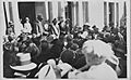
Cr George Handley, Mayor and Hubert Opperman in Wangaratta, 15 Nov 1927 after Opperman won the first stage of the Dunlop Grand Prix
-
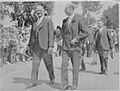
George Handley (Mayor) and Duke of Gloucester on his visit to Wangaratta 22 Oct 1934
-
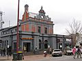
Wangaratta Old Post Office
-
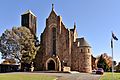
Holy Trinity Anglican Cathedral
-
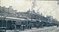
Murphy Street in 1908
-

Government Centre
-
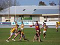
A Victorian Country Football League match in Wangaratta
-
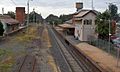
Wangaratta railway station

,_Duke_of_Gloucester,_visit_to_Wangaratta_22_Oct_1934.jpg)

.jpg)


