
Washington, North Carolina facts for kids
Quick facts for kids
Washington, North Carolina
|
|
|---|---|

Washington from the corner of Stewart Street and West Main Street
|
|

Washington, North Carolina
Location in North Carolina
|
|
| Country | United States |
| State | North Carolina |
| County | Beaufort |
| Government | |
| • Type | Council-Manager form of government |
| Area | |
| • Total | 9.02 sq mi (23.37 km2) |
| • Land | 8.19 sq mi (21.21 km2) |
| • Water | 0.83 sq mi (2.16 km2) |
| Elevation | 10 ft (3 m) |
| Population
(2010)
|
|
| • Total | 9,744 |
| • Estimate
(2019)
|
9,497 |
| • Density | 1,159.58/sq mi (447.72/km2) |
| Time zone | UTC−5 (Eastern (EST)) |
| • Summer (DST) | UTC−4 (EDT) |
| ZIP code |
27889
|
| Area code | 252 Exchanges: 940,946,948,974,975 |
| FIPS code | 37-71220 |
| GNIS feature ID | 0996823 |
Washington is a city in Beaufort County, North Carolina, United States, located on the northern bank of the Pamlico River. The population was 9,744 at the 2010 census. It is the county seat of Beaufort County. It is commonly known as "Original Washington" or "Little Washington" to distinguish it from Washington D.C. The closest major city is Greenville, approximately 20 miles (32 km) to the west.
Established in 1776 on land donated by Col. James Bonner, Washington is the first city named after George Washington, the first president of the United States.
Contents
History
The settlement at the current location of the city was founded in the 1770s by James Bonner on his land and was known as Forks of the Tar. In 1776, it was renamed Washington. During the American Revolutionary War, Washington served as a supply port while all major neighboring ports were under British siege.
The Bank of Washington, West End Branch, Beaufort County Courthouse, Bowers-Tripp House, North Market Street Historic District, Rosedale, Washington Historic District, and Zion Episcopal Church are listed on the National Register of Historic Places.
Demographics
| Historical population | |||
|---|---|---|---|
| Census | Pop. | %± | |
| 1850 | 2,015 | — | |
| 1860 | 1,599 | −20.6% | |
| 1870 | 2,094 | 31.0% | |
| 1880 | 2,462 | 17.6% | |
| 1890 | 3,545 | 44.0% | |
| 1900 | 4,842 | 36.6% | |
| 1910 | 6,211 | 28.3% | |
| 1920 | 6,314 | 1.7% | |
| 1930 | 7,035 | 11.4% | |
| 1940 | 8,569 | 21.8% | |
| 1950 | 9,698 | 13.2% | |
| 1960 | 9,939 | 2.5% | |
| 1970 | 8,961 | −9.8% | |
| 1980 | 8,418 | −6.1% | |
| 1990 | 9,075 | 7.8% | |
| 2000 | 9,583 | 5.6% | |
| 2010 | 9,744 | 1.7% | |
| 2019 (est.) | 9,497 | −2.5% | |
| U.S. Decennial Census | |||
2020 census
| Race | Num. | Perc. |
|---|---|---|
| White | 4,483 | 45.4% |
| Black or African American | 4,252 | 43.06% |
| Native American | 20 | 0.2% |
| Asian | 73 | 0.74% |
| Pacific Islander | 1 | 0.01% |
| Other/Mixed | 332 | 3.36% |
| Hispanic or Latino | 714 | 7.23% |
As of the 2020 United States Census, there were 9,875 people, 4,038 households, and 2,251 families residing in the city.
2010 census
As of the census of 2010, there were 9,744 people and 4,246 households in the city. The population density was 1,190.0 people per square mile (459.4/km2). There were 4,754 housing units at an average density of 580.5 per square mile (224.1/km2). The racial composition of the city was: 49.0% White, 45.50% Black or African American, 5.5% Hispanic or Latino American, 0.5% Asian American, 0.2% Native American, 0.1% Native Hawaiian or Other Pacific Islander, and 1.50% two or more races.
There were 4,754 households, out of which 22.5% had children under the age of 18 living with them, 37.3% were married couples living together, 21.1% had a female householder with no husband present, and 37.8% were non-families. 33.5% of all households were made up of individuals, and 15.3% had someone living alone who was 65 years of age or older. The average household size was 2.21 and the average family size was 2.93.
In the city, the age distribution of the population shows 24.7% under the age of 18, 8.6% from 18 to 24, 24.5% from 25 to 44, 22.6% from 45 to 64, and 19.6% who were 65 years of age or older. The median age was 40 years. For every 100 females, there were 77.4 males. For every 100 females age 18 and over, there were 70.8 males.
The median income for a household in the city was $22,057, and the median income for a family was $30,280. Males had a median income of $26,053 versus $21,641 for females. The per capita income for the city was $14,319. About 23.3% of families and 28.7% of the population were below the poverty line, including 42.8% of those under age 18 and 19.3% of those age 65 or over.
Transportation
Freeways and primary designated routes
- U.S. Route 264, dubbed Pactolus Highway, runs roughly east–west through Washington, following John Small Avenue and Fifth Street.
- U.S. Route 17 runs roughly north–south, following Carolina Avenue and North Bridge Street. South of Washington the road crosses the Pamlico River over the Pamlico-Tar Bridge.
North Carolina Highways
- N.C. Route 32 runs east–west through Washington, following River Road, Park Drive and 3rd Street. The road terminates at U.S. Route 17.
Features
This mid-sized rural town has been called the "Heart of the Inner Banks". It has a range of historical buildings and landmarks that add to its architectural interest, with some dating back to colonial times. A self-guided Historic Walking Tour allows visitors to explore the neighborhoods. Homes of Victorian design, Arts and Crafts, and traditional early-20th century dwellings stand side-by-side on sidewalks lined with crepe myrtle trees. Condominiums and townhouses have been constructed on the city's waterfront to bring residents back to the river, the town's starting place. A Farmer's and Artisan's Market is held regularly on the town's green areas on the waterfront.

The North Carolina Estuarium, located on the Pamlico River, portrays the ecology of North Carolina's estuaries. The Tar-Pamlico River and Pamlico Sound are featured in the more than 200 scientific and historic exhibits. In addition, a scenic 3/4 mile boardwalk takes visitors out along the Pamlico River. Washington features fishing and boating along the Pamlico River.
The Turnage Theatre, a restored historic vaudeville and movie theater, has opened in the downtown area and hosts plays and other types of live entertainment. Downtown restaurants benefit from a monthly downtown music and art festival called "Music in the Streets". The Beaufort County Arts Council, founded in 1972, is located in the restored Atlantic Coastline Railroad Station. It offers cultural programs including an annual juried fine arts show, a holiday arts and crafts show, a student art show, year-round exhibitions in the adjacent Washington Civic Center gallery, a series of free public concerts, an annual art camp for youth, workshops, lectures, and organized trips to attend cultural events throughout the region.
Evidence of the Union attack on Washington during the American Civil War is seen by the cannonball shot in an attorney's office located on historic Water Street. Confederates ships were shelling from the Tar River and forced the Union soldiers out. Both Union and Confederate soldiers burned many buildings as they retreated. Civil War re-enacters meet in the outskirts of Washington every year. Many nearby towns also contain Civil War artifacts and museums.
Notable people
- Bam Adebayo, NBA player for the Miami Heat
- Herbert Covington Bonner, Democratic congressman from North Carolina (1940–1965)
- Churchill C. Cambreleng, congressman (1821–1839) and US Minister to Russia
- Terrance Copper, former NFL player
- Josephus Daniels, Secretary of the Navy during World War I, and Ambassador to Mexico under President Franklin Delano Roosevelt's Administration.
- Susan Dimock, pioneer in American medicine and women's health. Studied at the University of Zurich in 1871, and practiced in Boston.
- Tillie Ehringhaus, First Lady of North Carolina
- Murray Hamilton, actor, best remembered for his playing the mayor in Jaws and Mr. Robinson in The Graduate
- Brad Linaweaver, science fiction writer, film producer and screenwriter, magazine publisher.
- Henry Churchill de Mille, playwright and the father of film pioneers Cecil B. DeMille and William C. deMille and the grandfather of the dancer and choreographer Agnes de Mille
- Walter Rasby, former NFL player
- Dominique Wilkins, nine-time NBA All-Star, noted as one of the best dunkers in NBA history, earning the nickname "The Human Highlight Film." In 2006, Wilkins was inducted into the Naismith Memorial Basketball Hall of Fame.
- Willie Williams, Karateka and mixed martial artist
- Ryan Zimmerman, MLB player for the Washington Nationals.
Education
Beaufort County Schools operates area public schools.
- Eastern Elementary School. Pre-k to 1st
- J. C. Tayloe Elementary School. 2nd to 3rd
- John Small Elementary School. 4th to 5th
- P. S. Jones Middle School. 6th to 8th (outside of the city limits)
- Washington High School. 9th to 12th
BHM Regional Library operates the Washington Public Library.
Images for kids
-
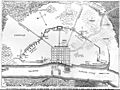
Map of Washington during the American Civil War, by Union soldier Solon M Allis
-
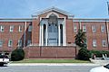
Beaufort County Courthouse
.jpg)

See also
 In Spanish: Washington (Carolina del Norte) para niños
