
Washington, Virginia facts for kids
Quick facts for kids
Washington, Virginia
|
|
|---|---|
|
Town
|
|

Location of Washington, Virginia
|
|
| Country | United States |
| State | Virginia |
| County | Rappahannock |
| Established as a town by the Virginia General Assembly | 1796 |
| Named for | George Washington |
| Government | |
| • Type | Mayor and Town Council |
| Area | |
| • Total | 0.26 sq mi (0.68 km2) |
| • Land | 0.26 sq mi (0.68 km2) |
| • Water | 0.00 sq mi (0.00 km2) |
| Elevation | 682 ft (208 m) |
| Population
(2010)
|
|
| • Total | 135 |
| • Estimate
(2019)
|
127 |
| • Density | 475.29/sq mi (183.79/km2) |
| Time zone | UTC−5 (Eastern (EST)) |
| • Summer (DST) | UTC−4 (EDT) |
| ZIP code |
22747
|
| Area code(s) | 540 |
| FIPS code | 51-83248 |
The town of Washington, Virginia, is a historic village located in the eastern foothills of the Blue Ridge Mountains near Shenandoah National Park. The entire town is listed on the National Register of Historic Places as a historic district, Washington Historic District. It is the county seat of Rappahannock County, Virginia.
The town was established by an act of the Virginia General Assembly in 1796 and as the county seat of Rappahannock County, Virginia, in 1833. The town was incorporated in 1894 and was rechartered by the Virginia General Assembly in 1985. A large portion of the town was designated as the Washington Historic District on the Virginia Landmarks Register and the National Register of Historic Places in 1975 and is considered to be the best preserved of county-seat communities in the Piedmont. The town is led by a 7-member elected Town Council composed of a mayor, a treasurer, and five other members, all of whom serve 4-year terms. The internationally recognized Inn at Little Washington is located in the town. The town combines a mixture of open spaces, residences, village commerce, tourism facilities, historic buildings, cultural offerings, and local government activities. Its population was 135 people in the 2010 census and was estimated to be 127 people in 2019. The area of the town is 182 acres (74 ha).
Contents
History

The Town of Washington was formerly the location of a trading post utilized by frontier families and members of the resident Manahoac tribe. All of the territory in and around the current town was under the ownership of Thomas Fairfax, 6th Lord Fairfax of Cameron. In 1748, Lord Fairfax met a 16-year-old George Washington, a distant relative of his. Being impressed by his character, Fairfax employed Washington to survey his lands west of the Blue Ridge Mountains. On July 24, 1749, the town layout as it appears today was surveyed and platted by Washington with the assistance of his chainmen John Lonem and Edward Corder as part of his service to Fairfax. The village was officially established as a Town by the Virginia General Assembly on December 14, 1795 when it gained the requisite population of 200. Records from an 1835 gazetteer state that the town contained one academy, fifty-five dwellings, four mercantile stores, two taverns, one house of worship, twenty-seven trade shops, and two large flour mills.
During the Civil War, a home on the town's Main Street served as a Confederate Hospital. In the late 19th century when rail became the main method of trade, the main east-west railway route of the time was constructed north of town through the accessible Thoroughfare Gap. Washington was relatively unaffected by the Industrial Age and thus the current town is quite similar to the one of 150 years ago. By the start of the 20th century the population reached three hundred, supporting businesses such as three garages and a barber shop. However, since then, the population had declined to less than 200.
Today, the town is probably most known for The Inn at Little Washington, a five-star restaurant, inn, and member of the Relais & Chateaux group. As such it attracts a discerning clientele from Washington, D.C. and its suburbs. Largely due to its influence, the town is also now home to several art galleries, unique shops, bed and breakfasts and restaurants. Dining aside, the town also attracts many art lovers, because of its numerous galleries, history buffs, and hikers that come into the county from the east en route for day hikes or weekend camping trips.
Ben Venue, Calvert Mill/Washington Mill, Mount Salem Baptist Meetinghouse, Sunnyside, and Washington Historic District are listed on the National Register of Historic Places.
Geography
Washington is located at 38°42′46″N 78°9′34″W / 38.71278°N 78.15944°W (38.712914, −78.159474).
According to the United States Census Bureau, the town has a total area of 0.3 square miles (0.7 km²), all of it land.
The town is located at the foot of the Blue Ridge Mountains.
Demographics
| Historical population | |||
|---|---|---|---|
| Census | Pop. | %± | |
| 1880 | 254 | — | |
| 1890 | 252 | −0.8% | |
| 1900 | 300 | 19.0% | |
| 1910 | 235 | −21.7% | |
| 1920 | 233 | −0.9% | |
| 1930 | 250 | 7.3% | |
| 1940 | 245 | −2.0% | |
| 1950 | 249 | 1.6% | |
| 1960 | 255 | 2.4% | |
| 1970 | 189 | −25.9% | |
| 1980 | 247 | 30.7% | |
| 1990 | 198 | −19.8% | |
| 2000 | 183 | −7.6% | |
| 2010 | 135 | −26.2% | |
| 2015 (est.) | 128 | −5.2% | |
|
|
|||
As of the census of 2000, there were 183 people, 88 households, and 49 families residing in the town. The population density was 692.5 people per square mile (271.8/km²). There were 117 housing units at an average density of 442.7 per square mile (173.7/km²). The racial makeup of the town was 83.06% White, 10.93% African American, 2.19% Asian, 2.19% from other races, and 1.64% from two or more races. Hispanic or Latino of any race were 3.83% of the population.
There were 88 households out of which 15.9% had children under the age of 18 living with them, 47.7% were married couples living together, 4.5% had a female householder with no husband present, and 44.3% were non-families. 36.4% of all households were made up of individuals and 8.0% had someone living alone who was 65 years of age or older. The average household size was 2.08 and the average family size was 2.69.
In the town, the population was spread out with 14.2% under the age of 18, 7.1% from 18 to 24, 21.3% from 25 to 44, 37.7% from 45 to 64, and 19.7% who were 65 years of age or older. The median age was 50 years. For every 100 females there were 72.6 males. For every 100 females age 18 and over, there were 68.8 males.
The median income for a household in the town was $53,125, and the median income for a family was $61,250. Males had a median income of $40,417 versus $19,063 for females. The per capita income for the town was $29,265. About 5.8% of families and 11.2% of the population were below the poverty line, including 11.1% of those under the age of eighteen and none of those sixty five or over.
Images for kids
-
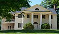
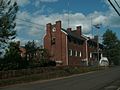
The historic Avon Hall home
-
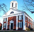
The courthouse of Washington, Virginia, constructed in 1833-1834
-
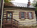
The log cabin at 322 Main Street, considered to be one of the earliest buildings constructed in the town
-
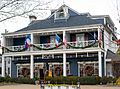
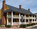
The Inn at Little Washington at Christmastime
-
-
-
-


.jpg)


See also
 In Spanish: Washington (Virginia) para niños
