Washington County, Iowa facts for kids
Quick facts for kids
Washington County
|
|
|---|---|

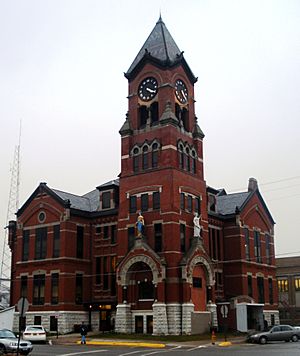
Washington County Courthouse
|
|

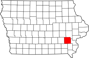
Location within the U.S. state of Iowa
|
|
 Iowa's location within the U.S. |
|
| Country | |
| State | |
| Founded | January 18, 1838 |
| Named for | George Washington |
| Seat | Washington |
| Largest city | Washington |
| Area | |
| • Total | 571 sq mi (1,480 km2) |
| • Land | 569 sq mi (1,470 km2) |
| • Water | 2.1 sq mi (5 km2) 0.4% |
| Population
(2020)
|
|
| • Total | 22,565 |
| • Density | 39.52/sq mi (15.258/km2) |
| Time zone | UTC−6 (Central) |
| • Summer (DST) | UTC−5 (CDT) |
| Congressional district | 2nd |
Washington County is a county located in the U.S. state of Iowa. As of the 2020 census, the population was 22,565. The county seat is Washington.
Washington County is included in the Iowa City Metropolitan Statistical Area.
Contents
History
Washington County was originally formed on January 18, 1838 as Slaughter County in honor of William B. Slaughter, the secretary of Wisconsin Territory. The county, still named Slaughter County, became part of Iowa Territory on July 4, 1838 when it was organized. January 25, 1839, Slaughter County was renamed Washington County, in honor of George Washington. The first settlers arrived in Washington County in 1835. The homesteads did not start until 1836. A town was built in the present day township of Oregon named Astoria. It became the first county seat and housed the first court house. In 1839, Washington became the final location of the seat of justice.
The first religious society organized by Reverend J.L. Kirkpatrick, a Methodist reverend was created in 1839. The first newspaper was established in 1853; lasting only two years before crumbling. The very next year another newspaper was created, which is still viable today. The major waterways through Washington County are the Skunk and English Rivers and the Crooked Creek. Timber is found in abundance around these bodies of waters which helps in the major business of lumber. Soon after the year 1855, a bank was started in the city of Washington and other institutions followed soon after. No major increase in population happened until the year 1858 when the Mississippi and Missouri Railroad was finished through Washington.
Geography
According to the U.S. Census Bureau, the county has a total area of 571 square miles (1,480 km2), of which 569 square miles (1,470 km2) is land and 2.1 square miles (5.4 km2) (0.4%) is water.
Major highways
Adjacent counties
- Iowa County (northwest)
- Johnson County (northeast)
- Louisa County (east)
- Henry County (southeast)
- Jefferson County (southwest)
- Keokuk County (west)
Demographics
| Historical population | |||
|---|---|---|---|
| Census | Pop. | %± | |
| 1850 | 4,957 | — | |
| 1860 | 14,235 | 187.2% | |
| 1870 | 18,952 | 33.1% | |
| 1880 | 20,374 | 7.5% | |
| 1890 | 18,468 | −9.4% | |
| 1900 | 20,718 | 12.2% | |
| 1910 | 19,925 | −3.8% | |
| 1920 | 20,421 | 2.5% | |
| 1930 | 19,822 | −2.9% | |
| 1940 | 20,055 | 1.2% | |
| 1950 | 19,557 | −2.5% | |
| 1960 | 19,406 | −0.8% | |
| 1970 | 18,967 | −2.3% | |
| 1980 | 20,141 | 6.2% | |
| 1990 | 19,612 | −2.6% | |
| 2000 | 20,670 | 5.4% | |
| 2010 | 21,704 | 5.0% | |
| 2020 | 22,565 | 4.0% | |
| U.S. Decennial Census 1790-1960 1900-1990 1990-2000 2010-2018 |
|||
2010 census
The 2010 census recorded a population of 21,704 in the county, with a population density of 38.1636/sq mi (14.7350/km2). There were 9,516 housing units, of which 8,741 were occupied.
2020 census
The 2020 census recorded a population of 22,565 in the county, with a population density of 39.4886/sq mi (15.2466/km2). 95.31% of the population reported being of one race. 83.15% were non-Hispanic White, 0.83% were Black, 7.14% were Hispanic, 0.31% were Native American, 0.51% were Asian, 0.01% were Native Hawaiian or Pacific Islander and 8.04% were some other race or more than one race. There were 9,573 housing units, of which 8,916 were occupied.
Communities
Cities
Unincorporated communities
Population ranking
The population ranking of the following table is based on the 2010 census of Washington County.
† county seat
| Rank | City/Town/etc. | Municipal type | Population (2010 Census) |
|---|---|---|---|
| 1 | † Washington | City | 7,266 |
| 2 | Kalona | City | 2,363 |
| 3 | Wellman | City | 1,408 |
| 4 | Riverside | City | 993 |
| 5 | Brighton | City | 652 |
| 6 | Ainsworth | City | 567 |
| 7 | Crawfordsville | City | 264 |
| 8 | West Chester | City | 146 |
| 9 | Coppock (partially in Henry and Jefferson Counties) | City | 47 |
Education
The county is served by 3 school districts
- Highland Community School District
- Mid-Prairie Community School District
- Washington Community School District.
Highland Community School District includes:
- Highland Elementary School
- Highland Middle School
- Highland High School
See also
 In Spanish: Condado de Washington (Iowa) para niños

