Washington County, Texas facts for kids
Quick facts for kids
Washington County
|
|
|---|---|

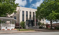
The Washington County Courthouse in Brenham
|
|

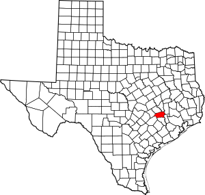
Location within the U.S. state of Texas
|
|
 Texas's location within the U.S. |
|
| Country | |
| State | |
| Founded | 1837 |
| Named for | George Washington |
| Seat | Brenham |
| Largest city | Brenham |
| Area | |
| • Total | 622 sq mi (1,610 km2) |
| • Land | 604 sq mi (1,560 km2) |
| • Water | 18 sq mi (50 km2) 2.9% |
| Population
(2020)
|
|
| • Total | 35,805 |
| • Density | 57.56/sq mi (22.226/km2) |
| Time zone | UTC−6 (Central) |
| • Summer (DST) | UTC−5 (CDT) |
| Congressional district | 10th |
Washington County is a county in Texas. As of the 2020 census, the population was 35,805. Its county seat is Brenham, which is located along U.S. Highway 290 seventy-two miles northwest of Houston. The county was created in 1835 as a municipality of Mexico and organized as a county in 1837. It is named for George Washington, the first president of the United States.
Washington County comprises the Brenham, TX Micropolitan Statistical Area, which is also included in the Houston-The Woodlands, TX Metropolitan Statistical Area.
Washington-on-the-Brazos in the county is notable as the site of the signing of the Texas Declaration of Independence during the Convention of 1836. Reflecting the county's history as a destination of mid-19th-century German immigrants who came after the 1848 German revolutions, in the 2000 US Census more than one-third of residents identified as being of German ancestry.
In 2013, the syndicated television series, Texas Country Reporter, hosted by Bob Phillips, declared the highways between Brenham and Chappel Hill as the No. 2 site for the viewing of wildflowers within Texas. The first ranking went to the Lady Bird Johnson Wildflower Center in Austin.
Contents
Geography
According to the U.S. Census Bureau, the county has a total area of 622 square miles (1,610 km2), of which 604 square miles (1,560 km2) is land and 18 square miles (47 km2) (2.9%) is water.
Major highways
Adjacent counties
- Brazos County (north)
- Grimes County (northeast)
- Waller County (east)
- Austin County (south)
- Fayette County (southwest)
- Lee County (west)
- Burleson County (northwest)
Demographics
| Historical population | |||
|---|---|---|---|
| Census | Pop. | %± | |
| 1850 | 5,983 | — | |
| 1860 | 15,215 | 154.3% | |
| 1870 | 23,104 | 51.9% | |
| 1880 | 27,565 | 19.3% | |
| 1890 | 29,161 | 5.8% | |
| 1900 | 32,931 | 12.9% | |
| 1910 | 25,561 | −22.4% | |
| 1920 | 26,624 | 4.2% | |
| 1930 | 25,394 | −4.6% | |
| 1940 | 25,387 | 0.0% | |
| 1950 | 20,542 | −19.1% | |
| 1960 | 19,145 | −6.8% | |
| 1970 | 18,842 | −1.6% | |
| 1980 | 21,998 | 16.7% | |
| 1990 | 26,154 | 18.9% | |
| 2000 | 30,373 | 16.1% | |
| 2010 | 33,718 | 11.0% | |
| 2020 | 35,805 | 6.2% | |
| U.S. Decennial Census 1850–2010 2010 2020 |
|||
2020 census
| Race / Ethnicity | Pop 2010 | Pop 2020 | % 2010 | % 2020 |
|---|---|---|---|---|
| White alone (NH) | 22,394 | 22,023 | 66.42% | 61.51% |
| Black or African American alone (NH) | 5,861 | 5,555 | 17.38% | 15.51% |
| Native American or Alaska Native alone (NH) | 61 | 75 | 0.18% | 0.21% |
| Asian alone (NH) | 432 | 547 | 1.28% | 1.53% |
| Pacific Islander alone (NH) | 7 | 14 | 0.02% | 0.04% |
| Some Other Race alone (NH) | 34 | 140 | 0.10% | 0.39% |
| Mixed Race/Multi-Racial (NH) | 288 | 1,026 | 0.85% | 2.87% |
| Hispanic or Latino (any race) | 4,641 | 6,425 | 13.76% | 17.94% |
| Total | 33,718 | 35,805 | 100.00% | 100.00% |
Note: the US Census treats Hispanic/Latino as an ethnic category. This table excludes Latinos from the racial categories and assigns them to a separate category. Hispanics/Latinos can be of any race.
Communities
Cities
Unincorporated communities
- Berlin
- Chappell Hill
- Gay Hill
- Greenvine
- Independence
- Latium
- Muellersville
- Prairie Hill
- Quarry
- Phillipsburg
- Rehburg
- Salem
- Washington-on-the-Brazos
- Zionville
Historic communities
- Cedar Creek – a mile north of Chappell Hill
Education
School districts:
- Brenham Independent School District
- Burton Independent School District
- Giddings Independent School District
- Hallettsville Independent School District
Blinn College is the designated community college for all of the county.
See also
 In Spanish: Condado de Washington (Texas) para niños


