
Waupaca, Wisconsin facts for kids
Quick facts for kids
Waupaca
|
|
|---|---|
|
City
|
|

Waupaca City Hall/Library Building
|
|

Location of Waupaca in Waupaca County, Wisconsin.
|
|

Waupaca
Location in Wisconsin
|
|
| Country | United States |
| State | Wisconsin |
| County | Waupaca |
| Area | |
| • Total | 8.21 sq mi (21.27 km2) |
| • Land | 7.92 sq mi (20.51 km2) |
| • Water | 0.29 sq mi (0.75 km2) |
| Population
(2010)
|
|
| • Total | 6,069 |
| • Estimate
(2019)
|
5,969 |
| • Density | 753.66/sq mi (291.01/km2) |
| Time zone | UTC-6 (Central (CST)) |
| • Summer (DST) | UTC-5 (CDT) |
| ZIP code |
54981
|
| Area code(s) | 715 & 534 |
| FIPS code | 55-84375 |
| Website | www.cityofwaupaca.org |


Waupaca is a city in and the county seat of Waupaca County in the U.S. state of Wisconsin. The population was 6,069 at the 2010 census.
The city is located mostly within the Town of Waupaca, and it is politically independent of the town. A portion extends west into the adjacent Town of Farmington, and there is also a noncontiguous area of the city in the Town of Lind to the south. The city is divided into natural areas, city areas, and industrial areas.
Contents
History
Native American mound builders lived in the area prior to European settlement. At one time there were 72 mounds n the area.
Waupaca was first settled in June 1849 by Capt. Augustus Hill Sr. and his sons, on a small waterfall along the Waupaca River. At the time, the area was home to the Menominee and Potowatomi tribes. The name for the settlement came either from the Indian term "waubuck seba," meaning pale water, or from a Potowatomi man named Sam Wapuka, or Chief Waupaca.
Waupaca was incorporated as a village on May 4, 1857 by act of the Wisconsin State Legislature. This act was repealed on April 7, 1862, but promptly revived on June 17 of the same year. Waupaca was incorporated as a city by the legislature on March 5, 1875. Beginning in the 1960s and continuing to the present, it has expanded through annexation.
Geography
Waupaca is located at 44°21′17″N 89°4′54″W / 44.35472°N 89.08167°W (44.354922, -89.081775).
According to the United States Census Bureau, the city has a total area of 8.11 square miles (21.00 km2), of which, 7.82 square miles (20.25 km2) is land and 0.29 square miles (0.75 km2) is water.
Transportation
|
|
U.S. 10 Eastbound US 10 routes to Appleton. Westbound, US 10 routes to Stevens Point. |
|
|
WIS 22 travels north to Clintonville and south to Wild Rose. |
|
|
WIS 49 routes northbound to Iola. Southbound, it runs concurrent with US 10 and routes to Berlin. |
|
|
WIS 54 travels east to New London and west to Wisconsin Rapids, Wisconsin. |
From 1899 to 1926, streetcar service was provided by the Waupaca Electric Light and Railway Company.
Airport
- KPCZ - Waupaca Municipal Airport
Demographics
| Historical population | |||
|---|---|---|---|
| Census | Pop. | %± | |
| 1880 | 1,392 | — | |
| 1890 | 2,127 | 52.8% | |
| 1900 | 2,912 | 36.9% | |
| 1910 | 2,789 | −4.2% | |
| 1920 | 2,839 | 1.8% | |
| 1930 | 3,131 | 10.3% | |
| 1940 | 3,458 | 10.4% | |
| 1950 | 3,921 | 13.4% | |
| 1960 | 3,984 | 1.6% | |
| 1970 | 4,342 | 9.0% | |
| 1980 | 4,472 | 3.0% | |
| 1990 | 4,957 | 10.8% | |
| 2000 | 5,676 | 14.5% | |
| 2010 | 6,069 | 6.9% | |
| 2019 (est.) | 5,969 | −1.6% | |
| U.S. Decennial Census | |||
2010 census
As of the census of 2010, there were 6,069 people, 2,702 households, and 1,356 families residing in the city. The population density was 776.1 inhabitants per square mile (299.7/km2). There were 2,996 housing units at an average density of 383.1 per square mile (147.9/km2). The racial makeup of the city was 96.6% White, 0.9% African American, 0.7% Native American, 0.3% Asian, 0.5% from other races, and 1.0% from two or more races. Hispanic or Latino of any race were 2.3% of the population.
There were 2,702 households, of which 25.9% had children under the age of 18 living with them, 34.9% were married couples living together, 10.9% had a female householder with no husband present, 4.4% had a male householder with no wife present, and 49.8% were non-families. 42.9% of all households were made up of individuals, and 20.7% had someone living alone who was 65 years of age or older. The average household size was 2.10 and the average family size was 2.92.
The median age in the city was 40.1 years. 22.1% of residents were under the age of 18; 8.4% were between the ages of 18 and 24; 24.7% were from 25 to 44; 24.6% were from 45 to 64; and 20.1% were 65 years of age or older. The gender makeup of the city was 47.5% male and 52.5% female.
Notable people
- Edward E. Browne, United States Representative
- Edward L. Browne, legislator
- Daniel F. Burnham, legislator
- George H. Calkins, legislator and physician
- Clarence Ekstrom, U.S. Navy Vice Admiral
- Fred R. Fisher, legislator
- Robert Frederick Froehlke, lawyer and government official
- Edwin J. Larson, legislator
- Alfred R. Lea, legislator
- Reid F. Murray, United States Representative
- Clay Perry, writer, coined the word "spelunker"
- Kevin David Petersen, legislator
- Richard E. Peterson, legislator, lawyer
- Myron Reed, legislator, lawyer
- Lyall Schwarzkopf, Minnesota state legislator
- Milan H. Sessions, legislator, lawyer
- Joseph H. Woodnorth, legislator
Images for kids
-
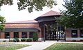
Library
-
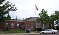
Waupaca Post Office, listed on the National Register of Historic Places
-
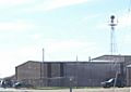
Waupaca Municipal Airport
-
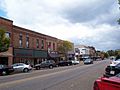
A portion of the Main Street Historic District, listed on the National Register of Historic Places
-
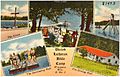
Postcard from c. 1930—1945 for Pine Lake Camp


.jpg)
See also
 In Spanish: Waupaca (Wisconsin) para niños
