Wayne County, Indiana facts for kids
Quick facts for kids
Wayne County
|
|
|---|---|

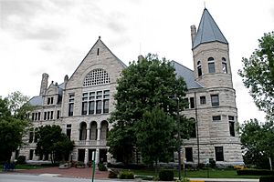
Wayne County Courthouse
|
|

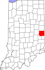
Location within the U.S. state of Indiana
|
|
 Indiana's location within the U.S. |
|
| Country | |
| State | |
| Founded | 1811 |
| Named for | Anthony Wayne |
| Seat | Richmond |
| Largest city | Richmond |
| Area | |
| • Total | 404.34 sq mi (1,047.2 km2) |
| • Land | 401.74 sq mi (1,040.5 km2) |
| • Water | 2.60 sq mi (6.7 km2) 0.64%% |
| Population | |
| • Estimate
(2018)
|
65,936 |
| • Density | 176/sq mi (68/km2) |
| Time zone | UTC−5 (Eastern) |
| • Summer (DST) | UTC−4 (EDT) |
| Congressional district | 6th |
| Indiana county number 89 | |
Wayne County is a county located in east central Indiana, United States, on the border with Ohio. As of the 2010 census, the population was 68,917. The county seat is Richmond.
Wayne County comprises the Richmond, IN Micropolitan Statistical Area.
Richmond hosts Earlham College, a small private liberal arts college.
Contents
History
Wayne County was formed in 1811. It was named for Gen. "Mad" Anthony Wayne, who was an officer during the Revolutionary War. Wayne is mainly remembered for his service in the 1790s in the Northwest Indian War, which included many actions in Indiana and Ohio.
The first county seat was Salisbury, Indiana, a town which no longer exists and later moved to Centerville, Indiana where it remained until a move to Richmond.
In the 1920s, Indiana had the strongest Ku Klux Klan organization in the country under Grand Dragons D. C. Stephenson and Walter F. Bossert, with control over the state legislature and an ally in Governor Ed Jackson. At its height, national membership during the second Klan movement reached 1.5 million, with 300,000 from Indiana. Records show that Wayne County was home to Whitewater Klan No. 60. Robert Lyons, of Richmond, was national chief of staff for the Klan.
Geography

According to the 2010 census, the county has a total area of 404.34 square miles (1,047.2 km2), of which 401.74 square miles (1,040.5 km2) (or 99.36%) is land and 2.60 square miles (6.7 km2) (or 0.64%) is water. Wayne County includes Indiana's highest natural elevation, Hoosier Hill, at 1,257 feet (383 m).
Adjacent counties
- Randolph County (north)
- Darke County, Ohio (northeast)
- Preble County, Ohio (east)
- Union County (south)
- Fayette County (southwest)
- Henry County (west)
Cities and towns
Unincorporated towns
|
Townships
|
|
|
Major highways
|
Climate and weather
| Weather chart for Richmond, Indiana | |||||||||||||||||||||||||||||||||||||||||||||||
|---|---|---|---|---|---|---|---|---|---|---|---|---|---|---|---|---|---|---|---|---|---|---|---|---|---|---|---|---|---|---|---|---|---|---|---|---|---|---|---|---|---|---|---|---|---|---|---|
| J | F | M | A | M | J | J | A | S | O | N | D | ||||||||||||||||||||||||||||||||||||
|
2.5
34
17
|
2.3
39
21
|
3.2
50
30
|
3.8
62
39
|
4.4
73
49
|
4.3
81
58
|
3.8
85
62
|
3.6
83
59
|
2.5
76
52
|
3
64
40
|
3.3
51
32
|
2.9
39
23
|
||||||||||||||||||||||||||||||||||||
| temperatures in °F precipitation totals in inches source: The Weather Channel |
|||||||||||||||||||||||||||||||||||||||||||||||
|
Metric conversion
|
|||||||||||||||||||||||||||||||||||||||||||||||
In recent years, average temperatures in Richmond have ranged from a low of 17 °F (−8 °C) in January to a high of 85 °F (29 °C) in July, although a record low of −27 °F (−33 °C) was recorded in January 1994 and a record high of 100 °F (38 °C) was recorded in July 1988. Average monthly precipitation ranged from 2.27 inches (58 mm) in February to 4.41 inches (112 mm) in May.
Demographics
| Historical population | |||
|---|---|---|---|
| Census | Pop. | %± | |
| 1820 | 12,119 | — | |
| 1830 | 18,571 | 53.2% | |
| 1840 | 23,290 | 25.4% | |
| 1850 | 25,320 | 8.7% | |
| 1860 | 29,558 | 16.7% | |
| 1870 | 34,048 | 15.2% | |
| 1880 | 38,613 | 13.4% | |
| 1890 | 37,628 | −2.6% | |
| 1900 | 38,970 | 3.6% | |
| 1910 | 43,757 | 12.3% | |
| 1920 | 48,136 | 10.0% | |
| 1930 | 54,809 | 13.9% | |
| 1940 | 59,229 | 8.1% | |
| 1950 | 68,566 | 15.8% | |
| 1960 | 74,039 | 8.0% | |
| 1970 | 79,109 | 6.8% | |
| 1980 | 76,058 | −3.9% | |
| 1990 | 71,951 | −5.4% | |
| 2000 | 71,097 | −1.2% | |
| 2010 | 68,917 | −3.1% | |
| 2018 (est.) | 65,936 | −4.3% | |
| U.S. Decennial Census 1790-1960 1900-1990 1990-2000 2010-2013 |
|||
As of the 2010 United States Census, there were 68,917 people, 27,551 households, and 18,126 families residing in the county. The population density was 171.5 inhabitants per square mile (66.2/km2). There were 31,242 housing units at an average density of 77.8 per square mile (30.0/km2). The racial makeup of the county was 90.2% white, 5.0% black or African American, 0.8% Asian, 0.2% American Indian, 0.1% Pacific islander, 1.1% from other races, and 2.7% from two or more races. Those of Hispanic or Latino origin made up 2.6% of the population. In terms of ancestry, 24.4% were German, 11.8% were Irish, 11.0% were English, and 10.9% were American.
Of the 27,551 households, 30.5% had children under the age of 18 living with them, 47.4% were married couples living together, 13.3% had a female householder with no husband present, 34.2% were non-families, and 28.5% of all households were made up of individuals. The average household size was 2.41 and the average family size was 2.93. The median age was 40.2 years.
The median income for a household in the county was $47,697 and the median income for a family was $51,155. Males had a median income of $40,644 versus $30,194 for females. The per capita income for the county was $21,789. About 12.6% of families and 16.1% of the population were below the poverty line, including 24.9% of those under age 18 and 9.3% of those age 65 or over.
Notable people
- Oliver P. Morton, 14th Governor of Indiana, born in Wayne County
- Walter R. Stubbs, 18th Governor of Kansas
- Ralph Teetor, inventor
- Levi Coffin, abolitionist, lived in Wayne Co, Indiana. He and his wife Catharine were active in the Underground Railroad, aiding refugees from slavery to reach Canada.
- Jim Jones, cult leader, attended school in Wayne County
- Timothy S. Jordan, Wisconsin politician, born in Wayne County
- Marcus Mote, early Indiana artist
- John Stark, California pioneer who rescued members of the Donner Party
See also
 In Spanish: Condado de Wayne (Indiana) para niños

