Waynoka, Oklahoma facts for kids
Quick facts for kids
Waynoka, Oklahoma
|
|
|---|---|

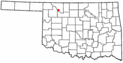
Location of Waynoka, Oklahoma
|
|
| Country | United States |
| State | Oklahoma |
| County | Woods |
| Area | |
| • Total | 0.99 sq mi (2.56 km2) |
| • Land | 0.99 sq mi (2.56 km2) |
| • Water | 0.00 sq mi (0.00 km2) |
| Elevation | 1,476 ft (450 m) |
| Population
(2010)
|
|
| • Total | 927 |
| • Estimate
(2019)
|
914 |
| • Density | 924.17/sq mi (356.77/km2) |
| Time zone | UTC-6 (Central (CST)) |
| • Summer (DST) | UTC-5 (CDT) |
| ZIP code |
73860
|
| Area code(s) | 580 |
| FIPS code | 40-79350 |
| GNIS feature ID | 1099446 |
Waynoka is a city in Woods County, Oklahoma, United States. It is located on U.S. Highway 281 and State Highway 14, seventy miles west of Enid. The population, which peaked at 2018 in 1950, stood at 927 according to the 2010 census.
Geography
Waynoka is located at 36°35′3″N 98°52′47″W / 36.58417°N 98.87972°W (36.584060, -98.879714). According to the United States Census Bureau, the city has a total area of 1.0 square mile (2.6 km2), all of it land.
Little Sahara State Park is 4 miles (6.4 km) south of the city. The park offers over 1,600 acres (6.5 km2) of rideable sand dunes ranging in height from 25 to 75 feet (23 m).
Demographics
| Historical population | |||
|---|---|---|---|
| Census | Pop. | %± | |
| 1910 | 1,160 | — | |
| 1920 | 1,500 | 29.3% | |
| 1930 | 1,840 | 22.7% | |
| 1940 | 1,584 | −13.9% | |
| 1950 | 2,018 | 27.4% | |
| 1960 | 1,794 | −11.1% | |
| 1970 | 1,444 | −19.5% | |
| 1980 | 1,377 | −4.6% | |
| 1990 | 947 | −31.2% | |
| 2000 | 993 | 4.9% | |
| 2010 | 927 | −6.6% | |
| 2019 (est.) | 914 | −1.4% | |
| U.S. Decennial Census | |||
As of the census of 2000, there were 993 people, 453 households, and 252 families residing in the city. The population density was 1,034.0 people per square mile (399.4/km2). There were 582 housing units at an average density of 606.0 per square mile (234.1/km2). The racial makeup of the city was 92.65% White, 2.32% African American, 1.51% Native American, 1.01% from other races, and 2.52% from two or more races. Hispanic or Latino of any race were 5.14% of the population.
There were 453 households, out of which 22.1% had children under the age of 18 living with them, 44.6% were married couples living together, 8.8% had a female householder with no husband present, and 44.2% were non-families. 42.6% of all households were made up of individuals, and 24.3% had someone living alone who was 65 years of age or older. The average household size was 2.07 and the average family size was 2.84.
In the city, the population was spread out, with 22.6% under the age of 18, 7.5% from 18 to 24, 22.4% from 25 to 44, 22.2% from 45 to 64, and 25.5% who were 65 years of age or older. The median age was 43 years. For every 100 females, there were 84.2 males. For every 100 females age 18 and over, there were 79.3 males.
The median income for a household in the city was $20,708, and the median income for a family was $28,833. Males had a median income of $24,063 versus $16,731 for females. The per capita income for the city was $12,493. About 13.5% of families and 16.6% of the population were below the poverty line, including 26.8% of those under age 18 and 9.5% of those age 65 or over.
Notable places and events
Waynoka is the home to the Cimarron River Stampede, a rodeo held annually since 1936. It is held on the second weekend of August.
The passenger and freight railroad stations originally built by the Santa Fe remain intact. The Waynoka Santa Fe Depot and Harvey House is listed on the NRHP.
Other NRHP-listed locations in town are the First Congregational Church at 1887 E. Cecil St., and the Waynoka Telephone Exchange Building at 200 S. Main St.
See also
 In Spanish: Waynoka (Oklahoma) para niños

