Weber County, Utah facts for kids
Quick facts for kids
Weber County
|
|
|---|---|

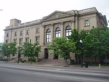
Historic United States Post Office and Courthouse in Ogden, Utah.
|
|

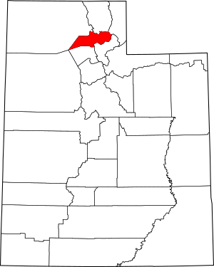
Location within the U.S. state of Utah
|
|
 Utah's location within the U.S. |
|
| Country | |
| State | |
| Founded | January 31, 1850 (created) March 3, 1852 (organized) |
| Named for | Weber River |
| Seat | Ogden |
| Largest city | Ogden |
| Area | |
| • Total | 659 sq mi (1,710 km2) |
| • Land | 576 sq mi (1,490 km2) |
| • Water | 83 sq mi (210 km2) 13% |
| Population
(2020)
|
|
| • Total | 262,223 |
| • Estimate
(2019)
|
260,213 |
| • Density | 397.91/sq mi (153.63/km2) |
| Time zone | UTC−7 (Mountain) |
| • Summer (DST) | UTC−6 (MDT) |
| Congressional district | 1st |
Weber County ( WEE-bər) is a county in the U.S. state of Utah. As of the 2010 census, the population was 231,236, making it Utah's fourth-most populous county. Its county seat and largest city is Ogden, the home of Weber State University. The county was named for the Weber River.
Weber County is part of the Ogden-Clearfield, UT Metropolitan Statistical Area as well as the Salt Lake City-Provo-Orem, UT Combined Statistical Area.
Contents
Geography
According to the U.S. Census Bureau, the county has an area of 659 square miles (1,710 km2), of which 576 square miles (1,490 km2) is land and 83 square miles (210 km2) (13%) is water. It is the second-smallest county in Utah by land area and third-smallest by total area.
The county extends from high in the Wasatch Range in the east into a portion of the Great Salt Lake to the west. The Weber and Ogden rivers and their tributaries run through its valleys. The Weber County Surveyor's office divides the county into two regions, the "Lower Valley" and the "Upper Valley", divided by the ridge of the Wasatch front range south through the county. The "Lower Valley" is the more county's populous part and is next to the Great Salt Lake. The "Upper Valley" is the eastern part of the county and consists mostly of the Ogden Valley, the watershed of the Ogden River.
Adjacent counties
- Box Elder County (northwest)
- Cache County (north)
- Rich County (northeast)
- Morgan County (south)
- Davis County (south)
- Tooele County (southwest)
National protected area
- Cache National Forest (part)
Demographics
| Historical population | |||
|---|---|---|---|
| Census | Pop. | %± | |
| 1850 | 1,186 | — | |
| 1860 | 8,675 | 631.5% | |
| 1870 | 7,858 | −9.4% | |
| 1880 | 12,344 | 57.1% | |
| 1890 | 22,723 | 84.1% | |
| 1900 | 25,239 | 11.1% | |
| 1910 | 35,179 | 39.4% | |
| 1920 | 43,663 | 24.1% | |
| 1930 | 52,172 | 19.5% | |
| 1940 | 56,714 | 8.7% | |
| 1950 | 83,319 | 46.9% | |
| 1960 | 110,744 | 32.9% | |
| 1970 | 126,278 | 14.0% | |
| 1980 | 144,616 | 14.5% | |
| 1990 | 158,330 | 9.5% | |
| 2000 | 196,533 | 24.1% | |
| 2010 | 231,236 | 17.7% | |
| 2020 | 262,223 | 13.4% | |
| US Decennial Census 1790–1960 1900–1990 1990–2000 2010–2019 2020 |
|||
2010 census
As of the 2010 United States Census, there were 231,236 people in the county, organized into 78,784 households and 57,867 families. The population density was 351/sqmi (135/km2). There were 86,187 housing units at an average density of 131 per square mile (50/km2). The racial makeup of the county was 85.2% White, 1.4% Black or African American, 1.3% Asian, 0.8% Native American, 0.3% Pacific Islander, 6.59% from other races, and 3.0% from two or more races. 16.7% of the population were Hispanic or Latino of any race.
In the 2000 United States Census, there were 196,533 people in the county, organized into 65,698 households and 49,536 families. The population density was 341/sqmi (132/km2). There were 70,454 housing units at an average density of 122 per square mile (47/km2). The racial makeup of the county was 87.69% White, 1.40% Black or African American, 1.28% Asian, 0.77% Native American, 0.16% Pacific Islander, 6.59% from other races, and 2.12% from two or more races. 12.65% of the population were Hispanic or Latino of any race.
By 2005 80.4% of the population was non-Hispanic whites. 1.5% was African-Americans while 0.9% was Native American. Asians were 1.4% of the population. Latinos were 15.2% of the county population.
There were 78,748 households, out of which 36.8% had children under the age of 18 living with them, 56.7% were married couples living together, 11.5% had a female householder with no husband present, and 26.5% were non-families. 21.1% of all households had an individual who was 65 years of age or older and 7.3% had someone living alone who was 65 years of age or older. The average household size was 2.90 and the average family size was 3.40.
Ages
| Age Range | Number | Percent |
|---|---|---|
| Under 5 years | 20,837 | 9.0 |
| 5 to 9 years | 19,667 | 8.5 |
| 10 to 14 years | 18,375 | 7.9 |
| 15 to 19 years | 17,261 | 7.5 |
| 20 to 24 years | 17,636 | 7.6 |
| 25 to 29 years | 19,131 | 8.3 |
| 30 to 34 years | 17,469 | 7.6 |
| 35 to 39 years | 14, 559 | 6.3 |
| 40 to 44 years | 12,899 | 5.6 |
| 45 to 49 years | 14,160 | 6.1 |
| 50 to 54 years | 14,123 | 6.1 |
| 55 to 59 years | 11,904 | 5.1 |
| 60 to 64 years | 9,824 | 4.2 |
| 65 years and over | 23,388 | 10.1 |
The median age was 30.7 years. For every 100 females, there were 100.7 males. For every 100 females age 18 and over, there were 99.0 males.
Income and employment
As of the 2010 census, the median income for a household in the county was $62,036, and the median income for a family was $71,359. Males had a median income of $49,081 versus $34,954 for females. The per capita income for the county was $25,275. 12.1% of the population and 8.7% of families were below the poverty line. Out of the total population, 15.4% of those under the age of 18 and 8.5% of those 65 and older were living below the poverty line.
The 2000 census found, the median income for a household in the county was $44,014, and the median income for a family was $49,724. Males had a median income of $36,239 versus $24,719 for females. The per capita income for the county was $18,246. 9.30% of the population and 6.90% of families were below the poverty line. Out of the total population, 11.10% of those under the age of 18 and 5.50% of those 65 and older were living below the poverty line.
In the 2010 census, 67.0% of people over 16 were in labor and 33.0% were not in labor. The unemployment rate was 3.2%.
Ancestry
As of 2017, the largest self-identified ancestry groups in Weber County, Utah were:
- English (21.6%)
- German (10.5%)
- "American" (7.5%)
- Irish (6.1%)
- Scottish (4.1%)
- Danish (3.9%)
- Italian (3.6%)
- Dutch (3.1%)
- Swedish (3.0%)
- Welsh (1.9%)
- Norwegian (1.9%)
Communities
Cities
- Farr West
- Harrisville
- Hooper
- Marriott-Slaterville
- North Ogden
- Ogden (county seat)
- Plain City
- Pleasant View
- Riverdale
- Roy
- South Ogden
- Uintah
- Washington Terrace
- West Haven
Town
Census-designated places
Unincorporated communities
- Nordic Valley
- Reese
- Taylor
- Warren
- West Weber
Education
Institutions and organizations of education in Weber County:
- Weber State University
- Ogden–Weber Technical College
- Ogden City School District
- Weber School District
Notable residents
- Hal Ashby - film director
- Rodney Bagley - developed catalytic converter
- Gilbert Belnap - pioneer, sheriff of Weber County 1862-1870
- Solon Borglum - sculptor
- Fawn M. Brodie - historian
- John Browning - firearms manufacturer
- Bernard DeVoto - historian
- David Eccles - businessman
- Lester Herrick - pioneer, sheriff of Weber County in 1860
- Jefferson Hunt - founded Huntsville
- J. Willard Marriott - businessman
- Herbert B. Maw - Utah governor
- David O. McKay
- Olene S. Walker - Utah governor
See also
 In Spanish: Condado de Weber para niños

