Webster County, Georgia facts for kids
Quick facts for kids
Webster County
|
|
|---|---|

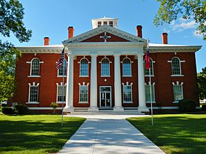
County courthouse in Preston
|
|

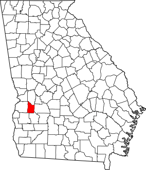
Location within the U.S. state of Georgia
|
|
 Georgia's location within the U.S. |
|
| Country | |
| State | |
| Founded | December 16, 1853 |
| Named for | Daniel Webster |
| Seat | Preston |
| Largest community | Preston |
| Area | |
| • Total | 210 sq mi (500 km2) |
| • Land | 209 sq mi (540 km2) |
| • Water | 1.1 sq mi (3 km2) 0.5%% |
| Population | |
| • Estimate
(2018)
|
2,611 |
| • Density | 13/sq mi (5/km2) |
| Time zone | UTC−5 (Eastern) |
| • Summer (DST) | UTC−4 (EDT) |
| Congressional district | 2nd |
Webster County is a county located in the west central portion of the U.S. state of Georgia. As of the 2010 Census reflected a population of 2,799, making it the third-least populous county in Georgia. The county seat is Preston.
Contents
History
Webster County was created by an act of the Georgia General Assembly on December 16, 1853, as Kinchafoonee County. A subsequent legislative act on February 21, 1856, changed the name to Webster. The land for the county came from portions of Stewart County.
The County is named for Daniel Webster, U.S. representative of New Hampshire and U.S. representative and U.S. senator of Massachusetts. Webster County's original name of Kinchafoonee came from the Kinchafoonee Creek which runs through the county.
Geography
According to the U.S. Census Bureau, the county has a total area of 210 square miles (540 km2), of which 209 square miles (540 km2) is land and 1.1 square miles (2.8 km2) (0.5%) is water.
The majority of Webster County, bordered to the southwest by State Route 520, is located in the Kinchafoonee-Muckalee sub-basin of the ACF River Basin (Apalachicola-Chattahoochee-Flint River Basin). The southwestern corner of the county is located in the Ichawaynochaway Creek sub-basin of the same ACF River Basin. A tiny edge of the southwestern border, just south of State Route 520, is located in the Middle Chattahoochee River-Walter F. George Lake sub-basin of the same ACF River Basin.
Major highways
Adjacent counties
- Marion County - north
- Sumter County - east
- Terrell County - south
- Randolph County - southwest
- Stewart County - west
Demographics
| Historical population | |||
|---|---|---|---|
| Census | Pop. | %± | |
| 1860 | 5,030 | — | |
| 1870 | 4,677 | −7.0% | |
| 1880 | 5,237 | 12.0% | |
| 1890 | 5,695 | 8.7% | |
| 1900 | 6,618 | 16.2% | |
| 1910 | 6,151 | −7.1% | |
| 1920 | 5,342 | −13.2% | |
| 1930 | 5,032 | −5.8% | |
| 1940 | 4,726 | −6.1% | |
| 1950 | 4,081 | −13.6% | |
| 1960 | 3,247 | −20.4% | |
| 1970 | 2,362 | −27.3% | |
| 1980 | 2,341 | −0.9% | |
| 1990 | 2,263 | −3.3% | |
| 2000 | 2,390 | 5.6% | |
| 2010 | 2,799 | 17.1% | |
| 2020 | 2,348 | −16.1% | |
| U.S. Decennial Census 1790-1960 1900-1990 1990-2000 2010-2013 |
|||
2010 census
As of the 2010 United States Census, there were 2,799 people, 1,119 households, and 788 families living in the county. The population density was 13.4 inhabitants per square mile (5.2/km2). There were 1,523 housing units at an average density of 7.3 per square mile (2.8/km2). The racial makeup of the county was 54.0% white, 42.3% black or African American, 0.3% Asian, 2.4% from other races, and 1.0% from two or more races. Those of Hispanic or Latino origin made up 3.5% of the population. In terms of ancestry, 18.6% were Irish, 9.9% were English, 8.0% were German, and 5.3% were American.
Of the 1,119 households, 34.4% had children under the age of 18 living with them, 46.8% were married couples living together, 16.4% had a female householder with no husband present, 29.6% were non-families, and 26.6% of all households were made up of individuals. The average household size was 2.50 and the average family size was 3.00. The median age was 40.6 years.
The median income for a household in the county was $25,708 and the median income for a family was $40,441. Males had a median income of $29,669 versus $27,745 for females. The per capita income for the county was $16,295. About 16.9% of families and 23.6% of the population were below the poverty line, including 25.8% of those under age 18 and 21.9% of those age 65 or over.
2020 census
| Race | Num. | Perc. |
|---|---|---|
| White | 1,136 | 48.38% |
| Black or African American | 1,063 | 45.27% |
| Asian | 12 | 0.51% |
| Pacific Islander | 6 | 0.26% |
| Other/Mixed | 72 | 3.07% |
| Hispanic or Latino | 59 | 2.51% |
As of the 2020 United States Census, there were 2,348 people, 1,140 households, and 724 families residing in the county.
Communities
Education
Webster County School District operates public schools.
See also
 In Spanish: Condado de Webster (Georgia) para niños

