Weekapaug, Rhode Island facts for kids
Quick facts for kids
Weekapaug, Rhode Island
|
|
|---|---|

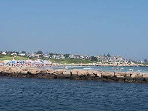
A photo of Weekapaug showing the breachway, jetty, channel, Fenway Beach, and numerous ocean front homes.
|
|
| Country | United States |
| State | Rhode Island |
| County | Washington |
| Area | |
| • Total | 1.20 sq mi (3.1 km2) |
| • Land | 1.16 sq mi (3.0 km2) |
| • Water | 0.036 sq mi (0.09 km2) |
| Elevation | 7 ft (2 m) |
| Population
(2010)
|
|
| • Total | 425 |
| • Density | 354.2/sq mi (137.1/km2) |
| Time zone | UTC-5 (Eastern (EST)) |
| • Summer (DST) | UTC-4 (EDT) |
| ZIP code |
02891
|
| Area code(s) | 401 |
| FIPS code | 44-75920 |
| GNIS feature ID | 2631342 |
Weekapaug is a census-designated place in southern Washington County, Rhode Island, part of the town of Westerly, Rhode Island. The population was 425 at the 2010 census.
Contents
History
Weekapaug has many private roads running through it and isn't as well known as neighboring Watch Hill, Rhode Island. It has had summer cottages since 1877. Weekapaug was known as Noyes Beach from 1701 to 1899. It was named after Reverend James Noyes who had purchased 300 acres (1.2 km2) of what was to become Weekapaug. Weekapaug is a Native American word meaning "end of pond". Niantics, Pequots, and Narrangansetts lived in this area before early settlers arrived.
In 1899, Frederick and Phebe Buffum opened the Weekapaug Inn for a first summer season of guests.
On September 21, 1938, The Hurricane of 1938 swept the barrier beach clean of houses and irreparably damaged the Weekapaug Inn. See Fredrick C. Buffum's first hand account. The Weekapaug Inn was rebuilt and reopened for guests in June 1939.
Geography
Two large saltwater ponds, Winnapaug Pond and Quonochontaug Pond, dominate the map of the area. The area just west of the breachway and channel that lead to Winnapaug pond defines the western area of Weekapaug and the breachway that leads to the Quonochontaug Pond is the eastern edge of the fire district. Both breachways are lined with rock jetties. Most of the rock is granite which was readily available in Westerly and used to be its number one industry. The breachway and jetties on Winnapaug were completed on May 5, 1954. The permanent breachway leading to Quonochontaug was completed on October 31, 1961.
In popular culture
The song "Weekapaug Groove" by the band Phish is named after the area. The song does not appear on any of their studio albums, but does appear on many of their live albums, such as Slip Stitch and Pass.
In several episodes of Family Guy, cutaways mention "off Route 2 in Weekapaug" as the location of a fictional establishment, "Al Harrington's Wacky Waving Inflatable Arm Flailing Tube Man Emporium and Warehouse".
See also
 In Spanish: Weekapaug (Rhode Island) para niños


