
Weengallon facts for kids
Quick facts for kids WeengallonQueensland |
|
|---|---|

Weengallon locality sign, eastern approach (2021)
|
|

Weengallon
Location in Queensland
|
|
| Population | 30 (2016 census) |
| • Density | 0.035/km2 (0.091/sq mi) |
| Postcode(s) | 4497 |
| Area | 855.5 km2 (330.3 sq mi) |
| Time zone | AEST (UTC+10:00) |
| LGA(s) | Goondiwindi Region |
| State electorate(s) | Southern Downs |
| Federal Division(s) | Maranoa |
Weengallon is a rural locality in the Goondiwindi Region, Queensland, Australia. In the 2016 census Weengallon had a population of 30 people.
The Barwon Highway goes through the locale.
History
The significant cultural area of the Ngaru-gi Gali ('to drink') or Weengallon rock wells are four large water holes, some twelve metres deep, and several smaller ones. These wells were used by the Indigenous Australians, including the Kalkadoon as they moved from Mount Isa south for ceremonies and business towards Goondiwindi, and further coastal towards the Bunya Mountains. Another rock well exists at Thornby on the Moonie Highway near Saint George (27°58′09″S 148°56′18″E / 27.969052°S 148.938276°E).
-
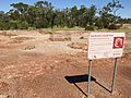
Weengallon Aboriginal rock wells (2021).
-
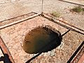
A large rock well (2021).


The Weengallon property was in existence by 1867, although in July that year, the 80 square miles (210 km2) run was forfeited for sale. While for cattle, it was noted in 1906 that there was not always water, and a distance from a railway station or siding. A water bore was subsequently sunk in 1911, later down to 3,000 feet (910 m).
A Weengallon Progress Association was in existence by 1913.
By the 1930s, the locale had a public hall, and hosted a ball by Queensland Country Women's Association, cricket, and later, an annual Catholic Ball.
The locality was officially named and bounded on 26 November 1999.
In the 2016 census Weengallon had a population of 30 people.
Gallery
-
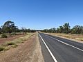
Barwon Highway between Gradna and Weengallon (2021).
-
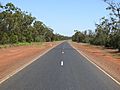
Barwood Highway towards Weengallon (2021).
-
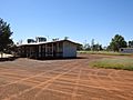
Weengallon community hall and tennis courts (2021).
-
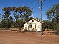
Our Lady Queen church (2021).


