
Weld, Maine facts for kids
Quick facts for kids
Weld, Maine
|
|
|---|---|

Webb Lake and Mount Blue
|
|

Weld, Maine
Location in Maine
|
|
| Country | United States |
| State | Maine |
| County | Franklin |
| Incorporated | 1816 |
| Area | |
| • Total | 62.87 sq mi (162.83 km2) |
| • Land | 59.50 sq mi (154.10 km2) |
| • Water | 3.37 sq mi (8.73 km2) |
| Elevation | 676 ft (206 m) |
| Population
(2020)
|
|
| • Total | 376 |
| • Density | 6/sq mi (2.4/km2) |
| Time zone | UTC-5 (Eastern (EST)) |
| • Summer (DST) | UTC-4 (EDT) |
| ZIP code |
04285
|
| Area code(s) | 207 |
| FIPS code | 23-81300 |
| GNIS feature ID | 0582798 |
Weld is a town in Franklin County, Maine, United States. The population was 376 at the 2020 census. Set beside Webb Lake and almost surrounded by mountains, Weld is noted for its scenic beauty. It is home to Mount Blue State Park, Camp Kawanhee for Boys, and Camp Lawroweld.
History
Originally called No. 5 (or Webb's Pond Plantation), it was first settled in 1800 by Nathaniel Kittredge and his family from Chester, New Hampshire. The town was part of an extensive tract purchased about 1790 from the state of Massachusetts by Jonathan Phillips of Boston. Phillips was an investor whose agent, Jacob Abbott of Wilton, New Hampshire, resold parcels of the land to settlers. Together with Benjamin Weld of Boston, Abbott and his brother-in-law Thomas Russell Jr. in 1815 bought what remained of the Phillips tract.
Incorporated on February 8, 1816, the town was named for its proprietor, Benjamin Weld, a member of the Weld family. Inauspiciously, 1816 was the Year Without a Summer, when unusually cold weather threatened northeastern communities with famine.
A longtime resident of Weld was Pomp Russell, an African-American man born in Charlestown, Massachusetts, in 1765. Russell served at the Battle of Bunker Hill as a young boy, and was later caught spying behind British lines. Russell was lined up to be shot when he managed to escape. Following the Revolutionary War Russell moved to New Hampshire, and then to Weld, the home of the Russell family, into which he had been adopted at age five, when Thomas Russell paid £5 for him. Pomp Russell was raised as a member of the Russell family, was awarded his freedom at age 21, and ultimately settled on land at Weld given him by Abel and Joseph Russell, sons of Thomas. Pomp Russell married Margaret Southwick of Charlestown, and he was a farmer.
Weld is located on a fairly level area of gravelly loam almost surrounded by mountains, some of which are beyond the town's limits. Farmers cultivated corn, potatoes, wheat and oats. Weld was noted for numerous and prolific apple orchards. Streams provided water power for mills, which included 5 sawmills, 3 box mills, a gristmill and a carding machine. It also produced fork and shovel handles, butter tubs, harness and tinware. Other industries were a starch factory, blacksmith and tannery. By 1870, the population was 1,130.
-
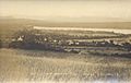
Bird's-eye view c. 1915
-
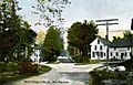
The Square c. 1906
-
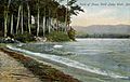
Webb Lake c. 1908
-
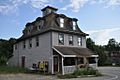
Mount Blue Trading Post


Geography
According to the United States Census Bureau, the town has a total area of 62.87 square miles (162.83 km2), of which, 59.50 square miles (154.10 km2) of it is land and 3.37 square miles (8.73 km2) is water. Weld is situated beside Webb Lake, which is drained by the Webb River, a tributary of the Androscoggin River.
The town is crossed by state routes 142 and 156. It borders the town of Phillips and Unincorporated Township No. 6 to the north, Avon and Temple to the east, and Carthage and Perkins Plantation to the south.
Weld is home to Spruce Mountain and Hurricane Mountain, and considered home to several summits outside the town's boundaries, including Tumbledown Mountain and Mount Blue.
Demographics
| Historical population | |||
|---|---|---|---|
| Census | Pop. | %± | |
| 1820 | 489 | — | |
| 1830 | 765 | 56.4% | |
| 1840 | 1,045 | 36.6% | |
| 1850 | 995 | −4.8% | |
| 1860 | 1,035 | 4.0% | |
| 1870 | 1,130 | 9.2% | |
| 1880 | 1,040 | −8.0% | |
| 1890 | 885 | −14.9% | |
| 1900 | 738 | −16.6% | |
| 1910 | 574 | −22.2% | |
| 1920 | 521 | −9.2% | |
| 1930 | 493 | −5.4% | |
| 1940 | 422 | −14.4% | |
| 1950 | 361 | −14.5% | |
| 1960 | 348 | −3.6% | |
| 1970 | 360 | 3.4% | |
| 1980 | 435 | 20.8% | |
| 1990 | 430 | −1.1% | |
| 2000 | 402 | −6.5% | |
| 2010 | 419 | 4.2% | |
| 2020 | 376 | −10.3% | |
| U.S. Decennial Census | |||
2010 census
As of the census of 2010, there were 419 people, 194 households, and 138 families living in the town. The population density was 7.0 inhabitants per square mile (2.7/km2). There were 632 housing units at an average density of 10.6 per square mile (4.1/km2). The racial makeup of the town was 97.9% White, 0.2% African American, 0.2% from other races, and 1.7% from two or more races. Hispanic or Latino of any race were 0.2% of the population.
There were 194 households, of which 15.5% had children under the age of 18 living with them, 64.4% were married couples living together, 2.1% had a female householder with no husband present, 4.6% had a male householder with no wife present, and 28.9% were non-families. 22.7% of all households were made up of individuals, and 7.7% had someone living alone who was 65 years of age or older. The average household size was 2.16 and the average family size was 2.46.
The median age in the town was 54 years. 11% of residents were under the age of 18; 5.9% were between the ages of 18 and 24; 14% were from 25 to 44; 45.1% were from 45 to 64; and 23.9% were 65 years of age or older. The gender makeup of the town was 51.3% male and 48.7% female.
Notable people
- Henry Braun, poet
- C. J. Stevens, author
See also
 In Spanish: Weld (Maine) para niños
