
Wells, Maine facts for kids
Quick facts for kids
Wells, Maine
|
||
|---|---|---|

Town Hall
|
||
|
||
| Motto(s):
The Friendliest Town In Maine
|
||

Wells, Maine
Location in Maine
|
||
| Country | United States | |
| State | Maine | |
| County | York | |
| Founded | 1643 | |
| Incorporated | 1653 | |
| Government | ||
| • Type | Town Meeting, Board of Selectmen, Town Manager | |
| Area | ||
| • Total | 73.61 sq mi (190.6 km2) | |
| • Land | 57.55 sq mi (149.1 km2) | |
| • Water | 16.06 sq mi (41.6 km2) | |
| Elevation | 177 ft (54 m) | |
| Population
(2020)
|
||
| • Total | 11,314 | |
| • Density | 153.702/sq mi (59.345/km2) | |
| Time zone | UTC−5 (Eastern (EST)) | |
| • Summer (DST) | UTC−4 (EDT) | |
| ZIP Codes |
04054 (Moody), 04090 (Wells)
|
|
| Area code(s) | 207 | |
| FIPS code | 23-81475 | |
| GNIS feature ID | 0582799 | |
| Website | www.wellstown.org | |

Wells is a resort town in York County, Maine, United States. Founded in 1643, it is the third-oldest town in Maine. The population was 11,314 at the 2020 census. Wells Beach is a popular summer destination.
Contents
History
The Abenaki Indians called the area Webhannet, meaning "at the clear stream", a reference to the Webhannet River.
Edmund Littlefield, an immigrant from the wool regions of Titchfield, England, built the first gristmill and later a woolen mill on the Webhannet River, becoming known as "The Father of Wells," where a monument commemorates his contribution. In 1622, the Plymouth Company in England awarded to Sir Ferdinando Gorges, Lord Proprietor of Maine, territory which included the Plantation of Wells. His young cousin, Thomas Gorges, acting as deputy and agent, in 1641 granted to Rev. John Wheelwright and other settlers from Exeter, New Hampshire the right to populate the land from northeast of the Ogunquit River to southwest of the Kennebunk River. Following the death of the elder Gorges in 1647, the Massachusetts Bay Colony laid claim to Maine. In 1653, Wells was incorporated, the third town in Maine to do so, and named after Wells, England, a small cathedral city in the county of Somerset. It then included Kennebunk, set off the year Maine became a state in 1820, and Ogunquit, designated a village within Wells by the legislature in 1913, then set off in 1980.
Wells was the resilient northeastern frontier of English settlement. Except for a few forts and garrisons, early attempts to colonize Maine above Wells were abandoned because of attacks by Native Americans allied with New France, which resented encroachment by New England in territory it considered its own, Acadia. Wells endured three major attacks, most famously the Raid on Wells in 1692. The region became less dangerous, however, after the Battle of Louisburg in 1745.
Many early Wells settlers joined the Continental Army and were Revolutionary War heroes including Captains Samuel Gooch, Nathanial Littlefield, and Jeremiah Storer. Ocean View Cemetery on Post Road contains a well designed Civil War monument and plot honoring its service members. Visitors can walk to Founder's Park just off of Post Road onto Sanford Road, which includes a light walking trail, picnic area, and the first settlement home. Monuments list the names of Wells' founding families.
The town developed as a farming community, producing hay and vegetables. Other industries included shipbuilding and fisheries. In the 19th century, with the arrival of the railroad, the town's beautiful beaches attracted tourists. Many inns and hotels were built along the seashore. Today, tourism remains important to the economy.

Wells celebrated its 350th anniversary in 2003. The year-long celebration included a New Year's Eve party with fireworks, parade, a visit by the traveling Russian circus, concerts, historical reenactments, and more. The town commissioned a member of the celebration committee, Kristi Borst, to design a town flag. Her design portrays historic aspects of the Town's settlement and agriculture as well as the 2003 Town Hall and focus on tourism represented by a train. Also included is the motto she penned for the project: "Proud of our Past, Ready for our Future".
Geography

Wells is on the southern coast of Maine, surrounded by Kennebunk to the northeast, Sanford to the northwest, North Berwick to the west, South Berwick to the southwest, and Ogunquit to the south.
According to the United States Census Bureau, the town has a total area of 73.61 square miles (190.65 km2), of which, 57.55 square miles (149.05 km2) of it is land and 16.06 square miles (41.60 km2) is water. Wells is drained by the Webhannet River. The highest point in town is an unnamed hill located a half mile south of the intersection of State Route 9 and Bragdon Road, which is 360 feet (110 m) above sea level. The lowest elevation is sea level, along the coastline with the Atlantic Ocean.
Wells is part of the Portland-South Portland-Biddeford Metropolitan Statistical Area.
Transportation

There are several transportation corridors connecting Wells with other communities:
- Interstate 95 (Maine Turnpike Exit 19)
- U.S. Route 1
- Maine State Route 9
- Maine State Route 9A
- Maine State Route 109
- The Pan Am Railways mainline (formerly the Boston & Maine Railroad)
Access to the Amtrak national passenger rail system is available at the Wells Regional Transportation Center, which is served by 10 Downeaster trains per day. The center has a park and ride lot and is adjacent to the I-95 interchange.
Places of worship

Baptist
Christian, interdenominational
Church of the Nazarene
Pentecostal
Roman Catholic
- Saint Mary's Church
Old Catholic United Church of Christ
Points of interest

- 7 miles of beaches with public parking areas: Drakes Island Beach, East Shore Beach, and Wells Beach, as well as the privately held Moody Beach.
- The "Antiques Mile" - dozens of antiques vendors lining Post Road between Wells Corner and the Wells/Kennebunk town line.
- Maine Diner
- Rachel Carson National Wildlife Refuge
- Wells National Estuarine Research Reserve and Historic Laudholm Farm
Demographics
| Historical population | |||
|---|---|---|---|
| Census | Pop. | %± | |
| 1790 | 3,070 | — | |
| 1800 | 3,692 | 20.3% | |
| 1810 | 4,489 | 21.6% | |
| 1820 | 2,660 | −40.7% | |
| 1830 | 2,978 | 12.0% | |
| 1840 | 2,978 | 0.0% | |
| 1850 | 2,945 | −1.1% | |
| 1860 | 2,878 | −2.3% | |
| 1870 | 2,773 | −3.6% | |
| 1880 | 2,450 | −11.6% | |
| 1890 | 2,029 | −17.2% | |
| 1900 | 2,007 | −1.1% | |
| 1910 | 1,908 | −4.9% | |
| 1920 | 1,943 | 1.8% | |
| 1930 | 2,047 | 5.4% | |
| 1940 | 2,144 | 4.7% | |
| 1950 | 2,321 | 8.3% | |
| 1960 | 3,528 | 52.0% | |
| 1970 | 4,448 | 26.1% | |
| 1980 | 8,211 | 84.6% | |
| 1990 | 7,778 | −5.3% | |
| 2000 | 9,400 | 20.9% | |
| 2010 | 9,589 | 2.0% | |
| 2020 | 11,314 | 18.0% | |
2010 Census
As of the census of 2010, there were 9,589 people, 4,120 households, and 2,734 families living in the town. The population density was 166.6 inhabitants per square mile (64.3/km2). There were 8,557 housing units at an average density of 148.7 per square mile (57.4/km2). The racial makeup of the town was 97.2% White, 0.5% African American, 0.2% Native American, 0.6% Asian, 0.2% from other races, and 1.3% from two or more races. Hispanic or Latino of any race were 1.2% of the population.
There were 4,120 households, of which 24.5% had children under the age of 18 living with them, 54.6% were married couples living together, 8.1% had a female householder with no husband present, 3.6% had a male householder with no wife present, and 33.6% were non-families. 26.2% of all households were made up of individuals, and 11.4% had someone living alone who was 65 years of age or older. The average household size was 2.30 and the average family size was 2.77.
The median age in the town was 48.5 years. 18.6% of residents were under the age of 18; 5.4% were between the ages of 18 and 24; 20.2% were from 25 to 44; 34.8% were from 45 to 64; and 21% were 65 years of age or older. The gender makeup of the town was 48.3% male and 51.7% female.
Education

There are four educational institutions in Wells: Wells Elementary School (kindergarten through fourth grade), Wells Junior High School (fifth grade through eighth grade), Wells High School (ninth grade through twelfth grade, as well as adult education programs), and York County Community College.
Wells is a member of the Wells-Ogunquit Community School District.
Notable people


- Kathleen Chase, Maine state representative
- Ronald F. Collins, Maine state senator
- Jonathan Courtney, Maine state senator
- Nate Dingle, NFL football player
- Daniel W. Gooch, US congressman
- Ivory Kimball, judge
- Steve Lavigne, comic book illustrator
- Nathaniel Littlefield, US congressman; captain, Revolutionary War, Coast Guard at Wells and Kittery
- Ryan Peters (stage name Spose), rapper
- John Fairfield Scamman, US congressman
- John Storer, founder of Storer College
- Guy Tripp, Business executive and U.S. Army brigadier general
- Esther Wheelwright, Mother Superior of the Ursuline order in Quebec City
- John Wheelwright, clergyman, original settler of Wells
Images for kids
-
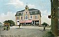
Wells Town Hall in 1911.
-

Wells High School
-
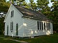
One of Wells' many one-room schools, preserved as a museum.
-
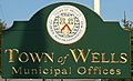
Sign at town hall
-
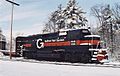
Freight train at Wells Industrial Park
-
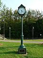
Memorial clock near train station
-
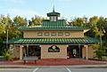
Wells train station
-
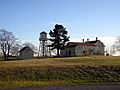
Laudholm main building
-
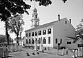
First Parish Unitarian-Universalist Church, Kennebunk, built in 1749 when Kennebunk was still part of Wells.
-
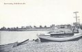
Boat landing in 1916
-
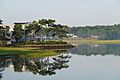
Ogunquit River in Moody, 2016

.jpg)


_2011.jpg)


See also
 In Spanish: Wells (Maine) para niños
