
West Wittering facts for kids
Quick facts for kids West Wittering |
|
|---|---|
 The Parish Church |
|

West Wittering
|
|
| Area | 13.63 km2 (5.26 sq mi) |
| Population | 2,700. 2011 Census |
| • Density | 197/km2 (510/sq mi) |
| OS grid reference | SZ779984 |
| • London | 60 miles (97 km) NE |
| Civil parish |
|
| District |
|
| Shire county | |
| Region | |
| Country | England |
| Sovereign state | United Kingdom |
| Post town | CHICHESTER |
| Postcode district | PO20 |
| Dialling code | 01243 |
| Police | Sussex |
| Fire | West Sussex |
| Ambulance | South East Coast |
| EU Parliament | South East England |
| UK Parliament |
|
| Website | Parish Council |
West Wittering is a village and civil parish situated on the Manhood Peninsula in the Chichester district of West Sussex, England. It lies near the mouth of Chichester Harbour on the B2179 road 6.5 miles (10.5 km) southwest of Chichester close to the border with Hampshire. The sandy beach has been described as having excellent water quality.
The population in 1872 was 616. The 2001 census records a population of 2,684. There is a primary school.
Contents
Governance
An electoral ward in the same name exists. This ward includes some of Birdham and at the 2011 Census had a total population of 4,472.
Natural history
Part of the Site of Special Scientific Interest Bracklesham Bay runs in between the coastline in the parish.
Chichester Harbour, a Site of Special Scientific Interest is partly within the parish. This is a wetland of international importance, a Special Protection Area for wild birds and a Special Area of Conservation. The harbour is of particular importance for wintering wildfowl and waders of which five species reach numbers which are internationally important.
Gallery
-
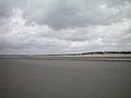
East Head sand dunes
-
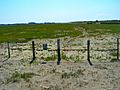
Salt marsh, East Head
-
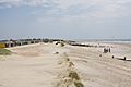
West Wittering beach


See also
 In Spanish: West Wittering para niños
