
Westford, Massachusetts facts for kids
Quick facts for kids
Westford, Massachusetts
|
||
|---|---|---|

Old Westford Academy,
now the Westford Museum |
||
|
||

Location in Middlesex County in Massachusetts
|
||
| Country | ||
| State | ||
| County | Middlesex | |
| Region | New England | |
| Settled | 1635 | |
| Incorporated | September 23, 1729 | |
| Government | ||
| • Type | Open town meeting | |
| Area | ||
| • Total | 81.1 km2 (31.3 sq mi) | |
| • Land | 79.3 km2 (30.6 sq mi) | |
| • Water | 1.9 km2 (0.7 sq mi) | |
| Elevation | 124 m (406 ft) | |
| Population
(2020)
|
||
| • Total | 24,643 | |
| • Density | 274.8/km2 (712.1/sq mi) | |
| Time zone | UTC−5 (Eastern) | |
| • Summer (DST) | UTC−4 (Eastern) | |
| ZIP Code |
01886
|
|
| Area code(s) | 351/978 | |
| FIPS code | 25-76135 | |
| GNIS feature ID | 0618244 | |
| Website | Town of Westford | |

Westford is a town in Middlesex County, Massachusetts, United States. The population was at 24,643 at the time of the 2020 Census.
Contents
History

Originally a part of neighboring Chelmsford, West Chelmsford soon grew large enough to sustain its own governance, and was officially incorporated as Westford on September 23, 1729.
In the late 18th and early 19th centuries, Westford primarily produced granite, apples, and worsted yarn. The Abbot Worsted Company was said to be the first company in the nation to use camel hair for worsted yarns. Citizens from Westford also had some notable involvement in the Revolutionary War. Westford Minutemen were alerted by efforts of Samuel Prescott who alerted Acton, to the southeast towards Stow.
Paul Revere's son attended Westford Academy and a bell cast by Revere graces its lobby today. A weather vane made by Paul Revere sits atop the Abbot Elementary school.
By the end of the American Civil War, as roads and transportation improved, Westford began to serve as a residential suburb for the factories of Lowell, becoming one of the earliest notable examples of suburban sprawl. Throughout the 20th century (and with the invention of the automobile), Westford progressively grew, continuing to serve as residential housing for the industries of Lowell, and later, Boston.
In the 1960s, the town was home to one of the research sites supporting Project West Ford.
By the 1970s, with the advent of the 128 Technology Belt, Westford began to act as a suburb for high-tech firms in Burlington, Woburn, and other areas, and later became a center of technology itself.
By the 1990s, Westford was home to offices for Red Hat, Samsung, Sonus Networks, Seagate, Iris Associates, Visual Solutions, and many other technology firms, most located along Massachusetts Route 110, parallel to I-495. It is also the North American headquarters for Puma, which holds a road race in town. The leading manufacturer of EEG electrodes, HydroDot Inc., located here in 2007.
Today, Westford's agricultural past has given way to rapidly expanding high technology industries, suburban retail, and upper-middle class residential areas.
Westford's inter-town sports teams have the colors of maroon, white, and sometimes black.
Geography

According to the United States Census Bureau, the town has a total area of 31.3 square miles (81 km2), of which 30.6 square miles (79 km2) is land and 0.7 square miles (1.8 km2) (2.30%) is water.
The town is bordered by Chelmsford to the east, Tyngsborough to the north, Groton to the west, Littleton to the southwest, Acton to the south, and Carlisle to the southeast.
Regionally, it is on the edge of the Merrimack Valley, Northern Middlesex County, and the Metrowest regions of Massachusetts.
Colloquially, the town is divided into different regions based on location, including Forge Village, Nabnasset, Graniteville, Parker Village, and Center of Town. The town's Master Plan maintains a distinction between the Commercial and Residential zones of the town, divided by Route 495. This allows for growth in the town while maintaining the character of this lovely area, and a balance of open spaces, without encroachment of commercial development as you approach Westford's Historic Town Center.
The town was rated as #11 Best Places to live by CNN Money in 2013.
Demographics
| Historical population | ||
|---|---|---|
| Year | Pop. | ±% |
| 1850 | 1,473 | — |
| 1860 | 1,624 | +10.3% |
| 1870 | 1,803 | +11.0% |
| 1880 | 2,147 | +19.1% |
| 1890 | 2,250 | +4.8% |
| 1900 | 2,624 | +16.6% |
| 1910 | 2,851 | +8.7% |
| 1920 | 3,170 | +11.2% |
| 1930 | 3,600 | +13.6% |
| 1940 | 3,830 | +6.4% |
| 1950 | 4,262 | +11.3% |
| 1960 | 6,261 | +46.9% |
| 1970 | 10,368 | +65.6% |
| 1980 | 13,434 | +29.6% |
| 1990 | 16,467 | +22.6% |
| 2000 | 20,754 | +26.0% |
| 2010 | 21,951 | +5.8% |
| 2020 | 24,643 | +12.3% |
| * = population estimate. Source: United States Census records and Population Estimates Program data. |
||
As of the 2010 census there were 21,951 people, 7,498 households, and 6,165 families residing in the town. The racial makeup of the town was 76.1% White, 0.40% African American, 0.1% Native American, 22.6% Asian (10.7% Indian, 8.2% Chinese, 1.6% Korean, 0.3% Cambodian, 0.2% Vietnamese, 0.2% Japanese, 0.1% Filipino, 0.1% Pakistani, 0.1% Bangladeshi), 0.0% Pacific Islander, 0.30% from other races, and 1.5% from two or more races. Hispanic or Latino of any race were 1.5% of the population.
As of the 2010 census, there were 7,498 households, out of which 45.3% had children under the age of 18 living with them, 72.5% were married couples living together, 7.3% had a female head of household, and 17.8% were other families. The average household size was 2.93 and the average family size was 3.27.
In the town, the population was spread out, with 31.8% under the age of 18, 4.2% from 18 to 24, 32.8% from 25 to 44, 23.9% from 45 to 64, and 7.2% who were 65 years of age or older. The median age was 37 years. For every 100 females, there were 99.0 males. For every 100 females age 18 and over, there were 95.4 males.
The median income for a household in the town was $121,136, and the median income for a family was $137,230. The per capita income for the town was $48,951. About 1.3% of families and 1.7% of the population were below the poverty line, including 2.2% of those under age 18 and 1.0% of those age 65 or over.
Transportation
Freight travels daily through Westford over the tracks of the historic Stony Brook Railroad. The line currently serves as a major corridor of Pan Am Railways' District 3 which connects New Hampshire and Maine with western Massachusetts, Vermont, and New York. Interstate 495 also passes through the town, linking it to other parts of the state as well as New Hampshire. US-3 passes through the town, although the nearest interchanges are located in neighboring Tyngsborough (exit 34) and Chelmsford (exit 33).
The LRTA 15 bus connects Westford along Route 110 with Chelmsford and the Lowell train station on the MBTA Commuter Rail Lowell Line.
Local routes passing through town are Massachusetts Routes 110, 40, 225, and 27.
Annual events

- In January or February, Westford Funfest has an annual Snow Sculpture contest - www.westford.com/funfest - depending on snow.
- In March or April, Westford FunFest has Breakfast with the Bunny.
- In May, the Westford Charitable Foundation 5k/10k Road Races, or The Westford Road Race are held.
- In May, the Kiwanis club hosts the Apple Blossom Parade and Carnival [1].
- In June, The First Parish Church hosts the Strawberry Festival.
- In August, the Westford Rotary Club hosts the Blues & Brews Festival as well as the Pig & Pepper Festival at the Nashoba Valley Ski Area, featuring top blues bands and many local beers to sample.
- In October, the Westford Education Foundation sponsors the Family Fun Run, Westford FunFest holds a Fall Festival at Kimball Farms, and the Nashoba Valley Ski Resort runs the Witch's Woods Halloween Screampark.
- In December, First Parish Church hosts the Westford Greens Sale, Westford Academy has its annual Holiday Bazaar, Westford FunFest holds the Festival of Trees, Wreaths and Gingerbread Creations and Breakfast with Santa..
- In December, Westford's United Methodist Church holds an outdoor Live Nativity overlooking the Stony Brook Reservoir pond, including farm animals, music & bonfire http://www.umcw.org/christmas
Education
Westford Public Schools
The Superintendent of Westford's Public Schools is Christopher Chew, who has held that role since 2021. The Assistant Superintendent is Kerry Clery.

- Westford Academy, Public High School
- Lloyd G. Blanchard Middle School, Public Middle School
- Stony Brook Middle School, Public Middle School
- Norman E. Day Elementary School, Public Elementary School (3–5)
- Abbot Elementary, Public Elementary School (3–5)
- John A. Crisafulli Elementary, Public Elementary School (3–5)
- Col. John Robinson School, Public Elementary School (K–2)
- Nabnasset Elementary School, Public Elementary School (K–2)
- Rita Edwards Miller School, Public Elementary School (K–2)
Nashoba Valley Technical High School District
Nashoba Valley Technical High School enrolls students from Westford, Chelmsford, Ayer, Groton, Littleton, Townsend, Shirley, and Pepperell
Established in 1968, Nashoba Valley Technical High School is a public, four-year, vocational high school.
- Nashoba Valley Technical High School, Public Regional Vocational Technical (known as Nashoba Tech, or The Tech)
Notable people
- Joel Abbot (1793–1855), born in Westford, noted naval officer
- Pat Bradley, Member of World Golf Hall of Fame
- Michael Fucito, Retired Major League Soccer player, first drafted by the Seattle Sounders FC
- Pamela L. Gay, Astronomer
- Ellen Henrietta Swallow Richards, creator of the field of home economics, first woman admitted to MIT, co-founder of American Association of University Women
- Lt. Col. John Robinson, Revolutionary War soldier
- Aaron Stanford, actor known for Nikita
- Nettie Stevens, American geneticist
Images for kids
-
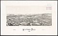
Lithograph of Westford from 1886 by L.R. Burleigh with list of landmarks
.jpg)
See also
 In Spanish: Westford (Massachusetts) para niños
