
Whetstone, London facts for kids
Quick facts for kids Whetstone |
|
|---|---|
 Barnet council offices dominate the centre of Whetstone. |
|

Whetstone
|
|
| OS grid reference | TQ265935 |
| London borough | |
| Ceremonial county | Greater London |
| Region | |
| Country | England |
| Sovereign state | United Kingdom |
| Post town | LONDON |
| Postcode district | N20 |
| Dialling code | 020 |
| Police | Metropolitan |
| Fire | London |
| Ambulance | London |
| EU Parliament | London |
| UK Parliament |
|
| London Assembly |
|
Whetstone is a place in the London Borough of Barnet, bearing the postcode N20. It is to the east of Totteridge, and these areas are known together as Totteridge and Whetstone. Whetstone is around 8.5 miles North of Charing Cross and is within the boundaries of the historic county of Middlesex. The combined areas of Totteridge and Whetstone was, at the outset of the 21st century, found to be the 63rd-richest of the more than 9,000 wards of the United Kingdom.
The High Road is the A1000, formerly known as the Great North Road, parts of it still bear this name. Until the late 19th century its tiny developed area was one of two main settlements in the ancient parish of Friern Barnet, the other being Colney Hatch. It was thus the northernmost settlement in the Ossulstone hundred. Whetstone is also the northernmost part of the parish of Finchley.
History
Whetstone originated in medieval times. It was an important staging post for coaches going north from London. There has been an inn on the site of the present Griffin pub for centuries, though the present building dates from 1928. The buildings to the left of the pub (viewed from the High Road) are late 15th century.
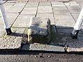
It is thought that Whetstone was named after the whetstone used to sharpen knives and other tools, a chunk of which is located on the High Road, on the pavement outside the Griffin pub (see picture). Some was used by soldiers about to fight in the Battle of Barnet.
There were early 19th century buildings opposite the Griffin pub [1] on the corner of Totteridge Lane, but they were demolished in 2001 and replaced by a new Boots the Chemist.
Russian spies
Whetstone may have been the location of a Soviet spy base. Tass, the Soviet news agency, had a radio monitoring station at The Lodge, 13 Oakleigh Park North, and the British security agencies became aware that it was being used to track its activities. According to local newspapers, the diplomatic immunity granted to the Russians was a worry for the British government since it effectively granted a licence for Tass to publish libellous newsletters without the threat of prosecution.
Despite this concern, the Soviets were subsequently granted permission to use specialist radio equipment which was then used to spy on the British. The matter was escalated to Prime Minister Clement Attlee and was discussed by senior members of the cabinet, and the Russians were eventually ordered to cease their radio monitoring operation.
Geography
 |
Totteridge | Oakleigh Park | Osidge | |
| Woodside Park | Brunswick Park | |||
| North Finchley | Friern Barnet | New Southgate |
Transport
Stations in the area are:
- Totteridge and Whetstone Station (Northern line)
Images for kids
-
The Whetstone

