
White Mountains (Arizona) facts for kids
Quick facts for kids White Mountains (Arizona) |
|
|---|---|

Mount Baldy
|
|
| Highest point | |
| Elevation | Mount Baldy 11,420 ft (3,480 m) 33°54′22″N 109°33′46″W / 33.90611°N 109.56278°W |
| Geography | |

Position of White Mountains inside Arizona
|
|
| Parent range | Arizona transition zone–Colorado Plateau |
The White Mountains of Arizona is a mountain range and mountainous region in the eastern part of the state, near the border with New Mexico; it is a continuation from the west of the Arizona transition zone–Mogollon Rim, with the Rim ending in western New Mexico. The White Mountains are a part of the Colorado Plateau high country of Northeast Arizona, the Navajo Nation, with the rest of the Plateau in eastern Utah, northwest New Mexico, and southwestern Colorado. Nearby communities include Show Low, Pinetop-Lakeside, Greer, St. Johns, Springerville, Eagar, and McNary. Much of the range is within the Fort Apache Indian Reservation.
The highest summit is Mount Baldy, with an elevation of 11,400 feet (3,475 m). The mountains are drained to the south by several tributaries of the Salt River, and to the north by the Little Colorado River. There are several small lakes.
The part of the White Mountains outside the reservation is in the Apache-Sitgreaves National Forests.
-
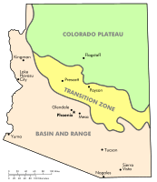
Physiographic regions of Arizona
-
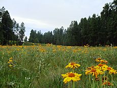
Wildflowers near Alpine, Arizona


See also
 In Spanish: Sierra Blanca (Arizona) para niños
