Whitesburg, Kentucky facts for kids
Quick facts for kids
Whitesburg, Kentucky
|
|
|---|---|

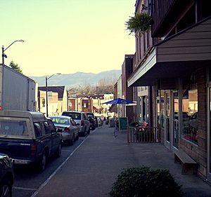
Downtown Whitesburg
|
|

Location in Letcher County, Kentucky
|
|
| Country | United States |
| State | Kentucky |
| County | Letcher |
| Incorporated | March 6, 1876 |
| Government | |
| • Type | Mayor-Council |
| Area | |
| • Total | 3.20 sq mi (8.30 km2) |
| • Land | 3.13 sq mi (8.11 km2) |
| • Water | 0.07 sq mi (0.18 km2) |
| Elevation | 1,171 ft (357 m) |
| Population
(2020)
|
|
| • Total | 1,773 |
| • Density | 566.09/sq mi (218.59/km2) |
| Time zone | UTC-5 (Eastern (EST)) |
| • Summer (DST) | UTC-4 (EDT) |
| ZIP code |
41858
|
| Area code(s) | 606 Exchanges: 632,633 |
| FIPS code | 21-82776 |
| GNIS feature ID | 0506678 |
Whitesburg is a home rule-class city in and the county seat of Letcher County, Kentucky, United States. The population was 2,139 at the 2010 census and an estimated 1,875 in 2018. It was named for C. White, a state politician.
Contents
Culture
Whitesburg is home to Appalshop, a multi-disciplinary arts and education center founded in 1969 which produces original films, video, theater, music and spoken-word recordings, radio, photography, multimedia, and books. WMMT 88.7 FM (Mountain Community Radio), also located in Whitesburg, was founded by Appalshop in 1985.
Whitesburg's major newspaper is The Mountain Eagle. Founded by Nehemiah Webb in 1907, the weekly paper has been owned by the Gish family of Letcher County since 1956. The Eagle has won numerous awards for its coverage of strip mining and its environmental effects, education, and political corruption.
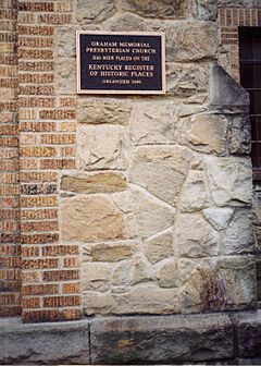
Whitesburg is known for its ubiquitous cut stone. The city was home to a community of Italian stonemasons who moved there with the coming of the Louisville and Nashville Railroad in 1911-1912. Those masons left their mark on the city and the surrounding county of Letcher. The city includes numerous ashlar stone retaining walls, foundations and bridge abutments, as well as several buildings covered entirely in sandstone pulled from the Kentucky River.
One of its best-known features is an arched stone bridge designed by Roy Crawford, a local mining and civil engineer and land surveyor who was educated through the International Correspondence School and in about 1925 founded R. R. Crawford Engineering, a company that remains family owned and operated. The bridge was built in 1938 across the North Fork of the Kentucky River. The downtown historic district includes many buildings built between 1914 and 1925, a time of great expansion in the town.
By 1921, all of the pre-Civil War buildings had been razed to make way for new, brick-and-stone edifices. Among the oldest commercial buildings are the former Lewis Wholesale building, built in 1914, which is now used as City Hall; the Fields Building, built 1911-1914, which now houses a restaurant, bookstore and law offices; and the Daniel Boone Hotel, a fine brick building with stone foundations and pressed metal cornice thought to have been built circa 1915. It includes several distinctive residences such as the Judge Ira Fields home (1897); the cut stone Palumbo House, and Italian villa-inspired house built by master stonemason John Palumbo; the stately Salyers House Bed and Breakfast, built for Confederate States of America Col. Logan Henry Neal Salyer in the early 20th century; and a Dutch Colonial style home ordered from the Sears Modern Home Catalog and delivered to its owner, in pieces, by railcar in 1928.
Whitesburg's streets were paved for the first time in 1924 and some of those original concrete streets are still in use. Broadway, one of those streets, is marked with the hoofprints of a cow, the footprints of chickens and of a barefoot child who ran across the street while the concrete was still wet. The Letcher County Fiscal Court completed construction of a recreation center in Whitesburg in 2011.
Residents of Whitesburg voted 2-1 on April 17, 2007, in favor of legalizing alcohol sales in restaurants which seat more than 100 people and get 70% of their revenue from food sales, known in Kentucky as 'moist' status. In 2012, city residents overwhelmingly voted to become completely 'wet,' bringing more than 60 years of prohibition in Whitesburg to its close.
Environment and Outdoor Recreation
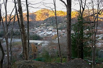
A paved rail-trail open to pedestrians and bicycles passes through the west end of the city into downtown, with future extensions planned through the eastern side of Whitesburg. The Town Hill Trail connects from downtown Whitesburg across a former wagon road to the top of Town Hill, with trail access to the communities of Cowan and Little Cowan as well as to High Rock, a large rock face on Pine Mountain.
Whitesburg also offers access to the Little Shepherd Trail (13 existing miles of which passes through the Pine Mountain Wildlife Management Area) and the Pine Mountain State Scenic Trail. The Pine Mountain State Scenic Trail is part of the Pine Mountain Wildlife Corridor, a protected contiguous forest block and migratory corridor from Virginia to Tennessee. Whitesburg is also located near the Pioneer Horse Trail and the Historic Scuttlehole Gap Wagon Road.
Primitive and RV camping is available at nearby Fish Pond Lake. Primitive camping is also available at Wiley's Last Resort, a privately owned campground, public art park, and festival ground at the top of Pine Mountain founded by Whitesburg poet and radio host Jim Webb.
Events

- Country Music Highway Road Rally - This antique car rally begins at Greenup, Kentucky, traverses the length of U.S. 23 in Kentucky, and ends at Whitesburg. Held during the peak color season in October, the rally draws sightseers from around the nation. Every county along the route is the home of at least one country music artist.
- Cowan Creek Mountain Music School - A set of week-long intensive classes in banjo, guitar, fiddle, square dance, storytelling and singing. The school is held in late June at the community of Cowan and in Whitesburg. It is open to children and adults.
- Letcher County Marching Invitational - On the last Saturday of October, the Letcher County Central High School Marching Band hosts a day of competition for marching bands from Southeast Kentucky, Southwest Virginia, and Northeast Tennessee. The contest has even brought in groups from five states.
- The Heritage 2KX Car Show, a custom and antique car show held annually in early September. The event attracts hundreds of show cars from around the region, and features a police-escorted drag through Whitesburg.
Geography
Whitesburg is located at 37°7′4″N 82°49′16″W / 37.11778°N 82.82111°W (37.117867, -82.821068).
According to the United States Census Bureau, the city has a total area of 3.1 square miles (8.0 km2), all land.
Climate
Whitesburg is located within a climatic transition zone between the humid subtropical climate and the humid continental climate zones. Summers are hot, humid and wet. July is the warmest month, with an average high of 86 °F (30 °C) and an average low of 63 °F (17 °C). Winters are generally cool to cold, with occasional snowfall. January is the coldest month, with an average high of 44 °F (7 °C) and an average low of 21 °F (-6 °C). May receives the most precipitation with an average of 5.83 inches (14.8 cm). The highest recorded temperature was 97 °F (36 °C) in 1998, and the lowest recorded temperature was -15 °F (-26 °C) in 1996.
| Climate data for Whitesburg, Kentucky | |||||||||||||
|---|---|---|---|---|---|---|---|---|---|---|---|---|---|
| Month | Jan | Feb | Mar | Apr | May | Jun | Jul | Aug | Sep | Oct | Nov | Dec | Year |
| Record high °F (°C) | 72 (22) |
76 (24) |
84 (29) |
88 (31) |
91 (33) |
95 (35) |
96 (36) |
96 (36) |
97 (36) |
91 (33) |
83 (28) |
75 (24) |
97 (36) |
| Average high °F (°C) | 44 (7) |
49 (9) |
58 (14) |
67 (19) |
76 (24) |
82 (28) |
86 (30) |
86 (30) |
80 (27) |
69 (21) |
59 (15) |
48 (9) |
67 (19) |
| Average low °F (°C) | 23 (−5) |
26 (−3) |
33 (1) |
44 (7) |
50 (10) |
58 (14) |
63 (17) |
62 (17) |
55 (13) |
41 (5) |
33 (1) |
26 (−3) |
43 (6) |
| Record low °F (°C) | −12 (−24) |
−15 (−26) |
−2 (−19) |
19 (−7) |
30 (−1) |
42 (6) |
51 (11) |
48 (9) |
36 (2) |
24 (−4) |
11 (−12) |
1 (−17) |
−15 (−26) |
| Average rainfall inches (mm) | 4.61 (117) |
4.34 (110) |
4.95 (126) |
4.65 (118) |
5.83 (148) |
3.86 (98) |
4.31 (109) |
3.89 (99) |
3.95 (100) |
3.45 (88) |
4.00 (102) |
4.52 (115) |
52.36 (1,330) |
| Source: The Weather Channel. | |||||||||||||
Demographics
| Historical population | |||
|---|---|---|---|
| Census | Pop. | %± | |
| 1900 | 194 | — | |
| 1910 | 321 | 65.5% | |
| 1920 | 706 | 119.9% | |
| 1930 | 1,804 | 155.5% | |
| 1940 | 1,616 | −10.4% | |
| 1950 | 1,393 | −13.8% | |
| 1960 | 1,774 | 27.4% | |
| 1970 | 1,137 | −35.9% | |
| 1980 | 1,525 | 34.1% | |
| 1990 | 1,636 | 7.3% | |
| 2000 | 1,600 | −2.2% | |
| 2010 | 2,139 | 33.7% | |
| 2020 | 1,773 | −17.1% | |
| U.S. Decennial Census | |||
According to the census of 2000, there were 1,600 people, 642 households, and 412 families residing in the city. The population density was 516.9 people per square mile (199.3/km2). There were 733 housing units at an average density of 236.8 per square mile (91.3/km2). The racial makeup of the city was 96.19% White, 0.62% African American, 2.62% Asian, 0.06% from other races, and 0.50% from two or more races. Hispanic or Latino of any race were 0.56% of the population.
There were 642 households, out of which 27.1% had children under the age of 18 living with them, 48.6% were married couples living together, 12.8% had a female householder with no husband present, and 35.8% were non-families. 34.3% of all households were made up of individuals, and 15.1% had someone living alone who was 65 years of age or older. The average household size was 2.21 and the average family size was 2.82.
In the city the population was spread out, with 18.6% under the age of 18, 7.8% from 18 to 24, 24.2% from 25 to 44, 25.4% from 45 to 64, and 24.1% who were 65 years of age or older. The median age was 45 years. For every 100 females, there were 79.0 males. For every 100 females age 18 and over, there were 76.1 males.
As a result of a survey taken subsequent to the census it was established that the city's population was made up of 3,100 residents. 1,241 households were left out of the census because neither the residents of Whitesburg's Housing Project nor residents of the Letcher Manor Nursing Home were counted in the census. When these facilities are included in the population count the number of city residents climbs to 3,100.
The median income for a household in the city was $28,750, and the median income for a family was $35,714. Males had a median income of $31,339 versus $25,478 for females. The per capita income for the city was $20,202. About 22.0% of families and 23.1% of the population were below the poverty line, including 27.2% of those under age 18 and 13.9% of those age 65 or over.
Education
Whitesburg has a lending library, a branch of the Letcher County Library.
Notable people
- Harry M. Caudill, author, historian, professor, lawyer, legislator, and environmentalist, 1922–1990
- Jessamyn Duke, Former martial arts fighter and professional wrestler signed under WWE on the Nxt brand
- Emery L. Frazier, mayor, state representative, Chief Clerk of the U.S. Senate, Secretary of the U.S. Senate, 1896–1973
- Tom Gish, publisher of The Mountain Eagle
- Goebel Ritter, player for the New York Knicks (1948–1951), and assistant superintendent of Whitesburg schools
- Lee Sexton, traditional Appalachian banjo musician
- Robb Webb, voice artist
See also
 In Spanish: Whitesburg (Kentucky) para niños


