
Wilhelmina Bay facts for kids

Wilhelmina Bay is a bay 24 kilometres (15 mi) wide along the west coast of Graham Land on the Antarctic Peninsula. It spans between the Reclus Peninsula to the northeast and Cape Anna to the southwest. It was discovered by the Belgian Antarctic Expedition of 1897–99 led by Adrien de Gerlache. The bay is named for Wilhelmina, Queen of the Netherlands, who reigned from 1890 to 1948. Wilhelmina Bay is a popular destination for tourist ships to Antarctica thanks to its scenery and abundant humpback whale population. The bay is surrounded by steep cliffs full of snow and glaciers.
Geography
Coastal
The southernmost part of the bay is a cove called Piccard Cove. It is bordered to the east by Sophie Cliff, a granite cliff which is the terminus of Balis Ridge. On the west side, O'Neal Point separates it from Beaupré Cove. Beaupré Cove is 1 nautical mile (2 km) wide, bordered by O'Neal Point and Jones Point. Its head is fed by Nadjakov Glacier. Hugershoff Cove lies at the southwestern end of Wilhelmina Bay, less than 1 nautical mile (2 km) south of Louise Island and Emma Island, and 2 nautical miles (4 km) northwest of Beaupré Cove.
Islands

The bay is large enough to contain several islands. The largest of these is Nansen Island or Isla Nansen Sur. Approximately 6.4 kilometres (4.0 mi) to the west is 2.8 km (1.5 nmi) long Emma Island, an icecap with bare jagged peaks projecting through. Ice-covered Louise Island is approximately 1 km (0.6 mi) long. It sits 1.6 km (1 mi) west of Emma Island, and 1.6 km east of Cape Anna and Anna Cove on the southwest side of the entrance to Wilhelmina Bay.
Nomenclature
Most features in the bay were charted by the Belgian Antarctic Expedition of 1897–99 under Gerlache. Gerlache provided names for many features, often after friends, supporters, and expedition members. Nansen Island was named for noted Arctic explorer Fridtjof Nansen. Emma Island was named for his mother, and Louise Island for his sister.
Some features charted by Gerlache were left unnamed. The United Kingdom Antarctic Place-Names Committee (UK-APC) named the following features in 1960. Piccard Cove was named for Swiss physicist Auguste Piccard. Beaupré Cove was named for French hydrographer Charles-François Beautemps-Beaupré. Jones Point was named for engineer Bennett M. Jones. Hugershoff Cove was named for German geodesist Carl R. Hugershoff.
O'Neal Point was named for American cartographer James D. O'Neal, although GNIS does not specify which agency named it.
Gallery
-
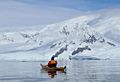
A kayaker watches whales in Wilhelmina Bay
-
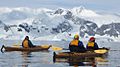
Kayakers in Wilhelmina Bay
-
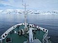
Expedition vessel Akademik Ioffe sailing into Wilhelmina Bay in January 2014
-
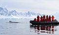
A tourist Zodiac has a close encounter with a humpback whale in Wilhelmina Bay


See also
 In Spanish: Bahía Wilhelmina para niños
- Geology of Gerlache Strait
- Plata Passage
