
Windsor, New South Wales facts for kids
Quick facts for kids WindsorNew South Wales |
|||||||||||||||
|---|---|---|---|---|---|---|---|---|---|---|---|---|---|---|---|

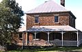
Historic Home in Windsor
|
|||||||||||||||

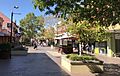
George Street Mall
|
|||||||||||||||
| Population | 1,891 (2016 census) | ||||||||||||||
| Established | 1791 | ||||||||||||||
| Postcode(s) | 2756 | ||||||||||||||
| Elevation | 21 m (69 ft) | ||||||||||||||
| Location |
|
||||||||||||||
| LGA(s) | City of Hawkesbury | ||||||||||||||
| State electorate(s) | Hawkesbury | ||||||||||||||
| Federal Division(s) | Macquarie | ||||||||||||||
|
|||||||||||||||
Windsor is a historic town north-west of Sydney, New South Wales, Australia. It is in the Hawkesbury local government area. The town sits on the Hawkesbury River, enveloped by farmland and Australian bush. Many of the oldest surviving European buildings in Australia are located at Windsor. It is 46 kilometres (29 mi) north-west of metropolitan Sydney, on the fringes of urban sprawl.
History
Windsor is the third-oldest place of British settlement on the Australian continent. Settlement at the location was first established about 1791, near the head of navigation on the Hawkesbury River (known as Deerubbin in Dharuk) and taking advantage of the fertile river flats for agriculture. The area was originally called Green Hills, but renamed Windsor (after Windsor in England). The town was officially proclaimed in a Government and General Order issued from Government House, Sydney, dated 15 December 1810, Governor Lachlan Macquarie having "marked out the district of Green Hills", which he "... called Windsor", after Windsor-on-the-Thames.
While in Windsor, Macquarie ordered the main institutions of organised settlement to be erected, such as a church, school-house, gaol and "commodious inn" (The Macquarie Arms). Of these new buildings, the most outstanding was Francis Greenway's Saint Matthew's Anglican Church, for which Macquarie himself chose the site. Samuel Marsden, principal chaplain of the colony, consecrated the church on 8 December 1822.
In 1813 a report was given to Governor Macquarie from Earl Bathurst detailing a proposed invasion of the Hawkesbury River by France. This planned invasion that did not eventuate, targeted the Windsor granary in order to cut off supply to Sydney, showing the relative importance of this new settlement on a global scale.
Windsor is approximately 60 kilometres north-west of Sydney, and the location was chosen because of the agricultural potential of the area and the location was accessible by coastal shipping from Sydney. It was known as the "bread basket", ensuring the survival of the starving colony. The extensive agriculture caused major silting in the Hawkesbury River, by the 1890s the river had become so blocked with silt, ships could not travel up to Windsor from the coast. By then the railway, in 1864, and the road, in 1814, had been built.
On 1 January 1803 Daniel Egan was born in Windsor. He went on to become Mayor of Sydney in 1853. Many of the oldest surviving European buildings in Australia are located at Windsor.
Heritage
The following buildings are listed on the Register of the National Estate.
- St Matthew's Anglican Church, Cemetery and Rectory, 1817–20
- Toll House, Bridge Street, c. 1835
- Claremont Cottage, Claremont Crescent, c. 1822
- Court House, Court Street, 1821
- Fairfield House, Fairfield Avenue, c. 1831
- Sunny Brae, Kable Street, 1875
- Cope House Group, George Street, c. 1835–1880
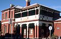
- George Street Inn Group, George Street, c. 1830–1841
- Public School, George and Dight Streets, 1869
- Loder House, George Street, 1834
- Johnston Street Group, 21–27 Johnston Street, c. 1840
- Former Bell Inn, Little Church Street, c. 1841
- Two Terraced Houses, 2–4 Catherine Street, c. 1840
- Two Terraced Houses, 5–7 Catherine Street, c. 1840
- Two Terraced Houses, 1–3 Little Church Street, c. 1840
- Tebbutt's Observatory and House, Palmer Street, 1844–79
- Group of Houses, 23–39 North Street, 28 North Street, c. 1840–1875
- Thompson Square Precinct and Bridge Street Buildings, including Hawkesbury Museum, c. 1830–1861
- Macquarie Arms Hotel, Thompson Square, built 1815
- Crescentville, 80 The Terrace, 1851
- The Doctor's House, 1–3 Thompson Square, 1830
Demographics


At the 2016 census, Windsor had a reported population of 1,891 people, with a median age of 42. The most common ancestries in Windsor were English (30.9%), Australian (28.9%), Irish (10.3%), Scottish (7.5%), and German (2.8%). Most people from Windsor were born in Australia (78.8%), followed by England (3.3%), and New Zealand (1.5%).
The most common religious group in Windsor was Christianity (65.8%), 25.2% being Catholic and 23.0% Anglican. The second largest group was No Religion (28.9%).
The most common occupations in Windsor included Professionals (15.9%), Technicians and Trades Workers (15.1%), Clerical and Administrative Workers (13.6%), Managers (12.8%), and Labourers (11.0%). The median weekly household income was A$1,422.
Geography
Floods are a major concern in Windsor. Its proximity to the Hawkesbury River has resulted in numerous disastrous floods. A horseshoe on the outside wall of the Macquarie Arms pub marks the level the flood peaked at in 1867, when beaches along the Hawkesbury to Barrenjoey were littered with the debris from the town.
Transport
Urban sprawl of metropolitan Sydney has almost reached Windsor. The town is now regarded as an outer suburb which has retained its appeal as a small country town. Growth in the Hawkesbury area has created an increased need for public transport and roads. Most people from Windsor traveled to work by car in 2016 (68.9%). Only 9.0% of people used public transport.
Windsor railway station opened 1 December 1864. It is on the Richmond branch of the T1 North Shore & Western Line and T5 Cumberland Line of the Sydney Trains network.
Located in the town centre is the Windsor Bridge which was constructed in 1874. It is the oldest existing crossing of the Hawkesbury River. There was a proposal in 2013 by the Government of New South Wales to demolish the existing bridge and replace it with a safer bridge. It was suggested by the political activist group Community Action for Windsor Bridge (CAWB) that a bypass is a better option to preserve history, ensure safety, and better manage the congestion of Windsor Road. Nevertheless, the new bridge was constructed despite the protests. On 18 May 2020 the replacement bridge was opened to traffic within Windsor, NSW.
The new bridge has a centreline height of 17.8 metres Australian Height Datum (AHD) (ie significantly higher than the typical water level – peak flood levels at Windsor bridge are 11.1 metres AHD and 17.2 metres AHD for the five year and 100 year ARI events respectively.). In 2021 the bridge was closed due to flooding in March 2021, and further work on the new bridge was completed
Windsor is also connected to Parramatta via the 31-kilometre-long (19 mi) Windsor Road cycleway, with much of its route via the North-West T-way.
Images for kids
-
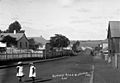
George Street Windsor
-
Windsor Post Office
-
Historic Home in Windsor
-
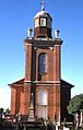
St Matthew's Anglican Church, designed by Francis Greenway
-
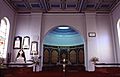
Interior of St Matthew's Church
-
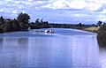
Hawkesbury River at Windsor
-
Poster Contest (Royal Australian Historical Society)

.jpg)


.jpg)
