
Wiwaxy Peak facts for kids
Quick facts for kids Wiwaxy Peaks |
|
|---|---|

Wiwaxy Peaks reflected in Opabin Lake
|
|
| Highest point | |
| Elevation | 2,706 m (8,878 ft) |
| Prominence | 174 m (571 ft) |
| Geography | |

Wiwaxy Peaks
Location in British Columbia

Wiwaxy Peaks
Location in Canada
|
|
| Parent range | Canadian Rockies |
| Topo map | NTS 82N/08 |
| Climbing | |
| First ascent | 1951 by T. Church, D. Pullin, W.Roubenheimer, T. Whalley |
| Easiest route | YDS 5.6 trad |
Wiwaxy Peaks is a 2,706-metre (8,878-foot) mountain near Lake O'Hara in Yoho National Park, in the Canadian Rockies of British Columbia, Canada. The Burgess Shale animal Wiwaxia corrugata is named after it. Its nearest higher peak is Mount Huber, 1.7 km (1.1 mi) to the east.
History
It was named in 1894 by Samuel E.S. Allen for the Stoney First Nations word for "windy".
The mountain's current name became official in 1924 when the Geographical Names Board of Canada approved its name.
The first ascent of the mountain was made in 1951 by T. Church, D. Pullin, W. Roubenheimer, and T. Whalley.
Geology
Wiwaxy Peaks is composed of sedimentary rock laid down during the Precambrian to Jurassic periods. Formed in shallow seas, this sedimentary rock was pushed east and over the top of younger rock during the Laramide orogeny.
Climate
Based on the Köppen climate classification, Wiwaxy Peaks is located in a subarctic climate with cold, snowy winters, and mild summers. Temperatures can drop below −20 C with wind chill factors below −30 C. Precipitation runoff from the peaks drains into tributaries of the Kicking Horse River which is a tributary of the Columbia River.
Routes
- Grassi Ridge
Gallery
-
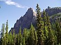
Wiwaxy Peak, from the Lake O'Hara campground
-
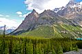
Wiwaxy Peaks and Huber
-
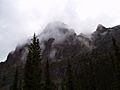
Wiwaxy Peak on a bad-weather morning


Nearby
 |
Cathedral Mountain | Mount Victoria |
|
||||
| Odaray Mountain | Mount Huber | ||||||
| Elizabeth Parker hut | Mount Lefroy | ||||||
| Lake O'Hara | Mount Hungabee |
