Wolffdene, Queensland facts for kids
Quick facts for kids WolffdeneQueensland |
|||||||||||||||
|---|---|---|---|---|---|---|---|---|---|---|---|---|---|---|---|

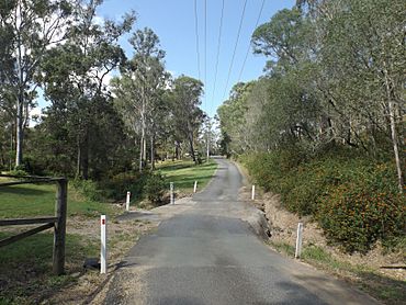
Wickham Road, 2016
|
|||||||||||||||
| Population | 288 (2016 census) | ||||||||||||||
| • Density | 25.95/km2 (67.2/sq mi) | ||||||||||||||
| Postcode(s) | 4207 | ||||||||||||||
| Area | 11.1 km2 (4.3 sq mi) | ||||||||||||||
| Time zone | AEST (UTC+10:00) | ||||||||||||||
| Location |
|
||||||||||||||
| LGA(s) | Logan City | ||||||||||||||
| State electorate(s) | Logan | ||||||||||||||
| Federal Division(s) | Forde | ||||||||||||||
|
|||||||||||||||
Wolffdene is a rural locality in the City of Logan, Queensland, Australia. In the 2016 census Wolffdene had a population of 288 people.
Contents
History
Wolffdene State School opened about 1 January 1892 and closed on 31 August 1942.
Proposed dam
In 1989, the Goss Government rejected a proposal to build Wolffdene Dam on the Albert River. Later, a dam near Glendower Homestead was once planned in a Queensland Government water strategy report from 1990. The option was discarded after it was revealed the site was too costly to build a dam for the amount of water it would have provided.
Education
There are no schools in Wolffdene. The nearest government schools are Windaroo State School in Mount Warren Park to the north and Cedar Creek State School in Cedar Creek to the south. The nearest government secondary school is Windaroo Valley State High School in Bahrs Scrub to the north.
Road infrastructure
The Beaudesert–Beenleigh Road runs through from south-east to north-east.


