Woodlynne, New Jersey facts for kids
Quick facts for kids
Woodlynne, New Jersey
|
|
|---|---|
|
Borough
|
|
| Borough of Woodlynne | |
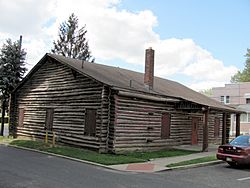
Woodlynne Log Cabin
|
|
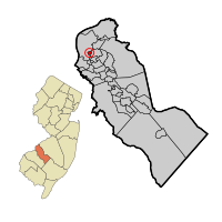
Woodlynne highlighted in Camden County. Inset: Location of Camden County in New Jersey.
|
|
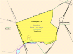
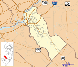
Census Bureau map of Woodlynne, New Jersey
|
|
| Country | |
| State | |
| County | Camden |
| Settled | 1681 |
| Incorporated | March 19, 1901 |
| Government | |
| • Type | Borough |
| • Body | Borough Council |
| Area | |
| • Total | 0.23 sq mi (0.58 km2) |
| • Land | 0.22 sq mi (0.56 km2) |
| • Water | 0.01 sq mi (0.02 km2) 3.04% |
| Area rank | 558th of 565 in state 35th of 37 in county |
| Elevation | 20 ft (6 m) |
| Population | |
| • Total | 2,978 |
| • Estimate
(2019)
|
2,915 |
| • Rank | 454th of 566 in state 28th of 37 in county |
| • Density | 13,600.4/sq mi (5,251.1/km2) |
| • Density rank | 18th of 566 in state 1st of 37 in county |
| Time zone | UTC−05:00 (Eastern (EST)) |
| • Summer (DST) | UTC−04:00 (Eastern (EDT)) |
| ZIP Code |
08107
|
| Area code(s) | 856 |
| FIPS code | 3400782450 |
| GNIS feature ID | 0885450 |
Woodlynne is a borough in Camden County, New Jersey, United States. As of the 2010 United States Census, the borough's population was 2,978, reflecting an increase of 182 (+6.5%) from the 2,796 counted in the 2000 Census, which had in turn increased by 249 (+9.8%) from the 2,547 counted in the 1990 Census. The borough is the state's eighth-smallest municipality. Established on the site of a defunct amusement park, Woodlynne is less than one-third the size of Six Flags Great Adventure and Safari.
Woodlynne was incorporated as a borough by an act of the New Jersey Legislature on March 19, 1901, from portions of Haddon Township. In 1906, the City of Camden made an unsuccessful attempt to annex Woodlynne.
Woodlynne had the highest property tax rate in New Jersey, with an equalized rate of 7.384% in 2020, compared to a statewide average of 2.279% and 3.470% in Camden County.
Contents
History
First settled in 1681, a property owned by Mark Newbie was called Lynnewood, named for the linden trees in the area. The name was changed from Lynnewood to Woodlynne in 1892, due to conflicts with the name of another municipality.
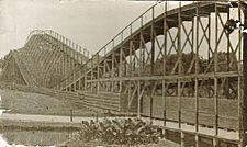
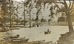
Woodlynne Amusement Park, which encompassed Woodlynne Lake (no longer in existence), operated between the years 1895 and 1914 in the area that now comprises the town of Woodlynne. The New Camden Land Improvement Company commissioned the creation of Woodlynne Amusement Park on the estate of Charles M. Cooper in 1892. A fire destroyed the park in 1914. The roller coaster that once stood in Woodlynne Amusement Park now resides in Clementon Amusement Park and Splash World Waterpark in Clementon. Homes built over the old lake tend to flood in the basements during heavy rainstorms.
The Camden and Suburban Railway Company, formed in 1896, established a housing development in a section of Woodlynne Amusement Park, which contributed to its incorporation as Woodlynne Borough in 1901.
Geography
According to the United States Census Bureau, the borough had a total area of 0.226 square miles (0.585 km2), including 0.219 square miles (0.567 km2) of land and 0.007 square miles (0.018 km2) of water (3.12%).
Woodlynne borders the Borough of Collingswood and the City of Camden.
Climate
The climate in this area is characterized by hot, humid summers and generally mild to cool winters. According to the Köppen Climate Classification system, Woodlynne has a humid subtropical climate, abbreviated "Cfa" on climate maps.
Demographics
| Historical population | |||
|---|---|---|---|
| Census | Pop. | %± | |
| 1900 | 388 | — | |
| 1910 | 500 | 28.9% | |
| 1920 | 1,515 | 203.0% | |
| 1930 | 2,878 | 90.0% | |
| 1940 | 2,861 | −0.6% | |
| 1950 | 2,776 | −3.0% | |
| 1960 | 3,128 | 12.7% | |
| 1970 | 3,101 | −0.9% | |
| 1980 | 2,578 | −16.9% | |
| 1990 | 2,547 | −1.2% | |
| 2000 | 2,796 | 9.8% | |
| 2010 | 2,978 | 6.5% | |
| 2019 (est.) | 2,915 | −2.1% | |
| Population sources: 1900-2000 1900-1920 1900-1910 1910-1930 1930-1990 2000 2010 |
|||
Census 2010
As of the census of 2010, there were 2,978 people, 917 households, and 700 families residing in the borough. The population density was 13,600.4 per square mile (5,251.1/km2). There were 1,016 housing units at an average density of 4,640.0 per square mile (1,791.5/km2)*. The racial makeup of the borough was 28.17% (839) White, 33.55% (999) Black or African American, 0.71% (21) Native American, 9.70% (289) Asian, 0.03% (1) Pacific Islander, 23.10% (688) from other races, and 4.73% (141) from two or more races. [[Hispanic (U.S. Census)|Hispanic or Latino of any race were 38.28% (1,140) of the population.
There were 917 households out of which 42.5% had children under the age of 18 living with them, 37.6% were married couples living together, 31.0% had a female householder with no husband present, and 23.7% were non-families. 18.6% of all households were made up of individuals, and 4.6% had someone living alone who was 65 years of age or older. The average household size was 3.25 and the average family size was 3.67.
In the borough, the population was spread out with 30.2% under the age of 18, 12.9% from 18 to 24, 29.9% from 25 to 44, 20.8% from 45 to 64, and 6.1% who were 65 years of age or older. The median age was 29.3 years. For every 100 females there were 97.7 males. For every 100 females ages 18 and old there were 90.6 males.
The Census Bureau's 2006-2010 American Community Survey showed that (in 2010 inflation-adjusted dollars) median household income was $41,516 (with a margin of error of +/- $6,233) and the median family income was $45,313 (+/- $17,965). Males had a median income of $39,020 (+/- $7,398) versus $32,688 (+/- $8,474) for females. The per capita income for the borough was $18,210 (+/- $2,557). About 14.8% of families and 14.2% of the population were below the poverty line, including 20.9% of those under age 18 and none of those age 65 or over.
Census 2000
As of the 2000 United States Census there were 2,796 people, 912 households, and 684 families residing in the borough. The population density was 12,939.4 people per square mile (4,907.0/km2). There were 1,012 housing units at an average density of 4,683.4 per square mile (1,776.1/km2). The racial makeup of the borough was 48.43% White, 22.71% African American, 0.57% Native American, 12.27% Asian, 11.59% from other races, and 4.43% from two or more races. Hispanic or Latino of any race were 20.60% of the population.
There were 912 households, out of which 42.4% had children under the age of 18 living with them, 42.1% were married couples living together, 25.0% had a female householder with no husband present, and 25.0% were non-families. 20.7% of all households were made up of individuals, and 7.5% had someone living alone who was 65 years of age or older. The average household size was 3.07 and the average family size was 3.52.
In the borough the population was spread out, with 32.4% under the age of 18, 8.7% from 18 to 24, 31.3% from 25 to 44, 18.8% from 45 to 64, and 8.7% who were 65 years of age or older. The median age was 31 years. For every 100 females, there were 95.0 males. For every 100 females age 18 and over, there were 85.6 males.
The median income for a household in the borough was $39,138, and the median income for a family was $39,669. Males had a median income of $33,520 versus $26,885 for females. The per capita income for the borough was $14,757. About 11.7% of families and 13.9% of the population were below the poverty line, including 21.5% of those under age 18 and 6.2% of those age 65 or over.
Transportation
Roads and highways
As of May 2010[update], the borough had a total of 5.69 miles (9.16 km) of roadways, of which 5.20 miles (8.37 km) were maintained by the municipality, 0.30 miles (0.48 km) by Camden County and 0.19 miles (0.31 km) by the New Jersey Department of Transportation.
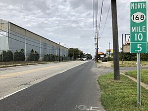
New Jersey Route 168 and U.S. Route 130 are the main highways serving Woodlynne. Route 168 skims the western border of Woodlynne, while US 130 brushes the eastern edge of the borough.
Public transportation
The Ferry Avenue station, located in Woodlynne and Camden, provides PATCO Speedline service between the 15–16th & Locust station in Philadelphia and the Lindenwold station.
NJ Transit bus service is available on routes 400 (between Sicklerville and Philadelphia), 403 (between Turnersville and Camden via Lindenwold PATCO station), 450 (between Cherry Hill and Camden via Audubon) and 453 (between Ferry Avenue PATCO station and Camden).
Points of interest
- The Woodlynne war memorial, commemorating residents of Woodlynne who lost their lives in World War I, World War II, the Korean War, and the Vietnam War, is located on Woodlynne Avenue.
- Woodlynne School District's 2014–15 School Report Card from the New Jersey Department of Education
Education
The Woodlynne School District serves public school students in pre-kindergarten through eighth grade at Woodlynne Elementary School. As of the 2019–20 school year, the district, comprised of one school, had an enrollment of 403 students and 33.1 classroom teachers (on an FTE basis), for a student–teacher ratio of 12.2:1.
Students in public school for ninth through twelfth grades attend Collingswood High School in neighboring Collingswood as part of a sending/receiving relationship with the Collingswood Public Schools, together with students from Oaklyn, New Jersey. As of the 2019–20 school year, the high school had an enrollment of 718 students and 64.5 classroom teachers (on an FTE basis), for a student–teacher ratio of 11.1:1.
See also
 In Spanish: Woodlynne para niños


