
Woodside, London facts for kids
Quick facts for kids Woodside |
|
|---|---|
 Woodside War Memorial on Woodside Green |
|

Woodside
|
|
| Population | 16,743 (2011 Census Ward) |
| OS grid reference | TQ344672 |
| London borough | |
| Ceremonial county | Greater London |
| Region | |
| Country | England |
| Sovereign state | United Kingdom |
| Post town | CROYDON |
| Postcode district | CR0 |
| Post town | LONDON |
| Postcode district | SE25 |
| Dialling code | 020 |
| Police | Metropolitan |
| Fire | London |
| Ambulance | London |
| EU Parliament | London |
| UK Parliament |
|
| London Assembly |
|
Woodside is an area in south London, in the London Borough of Croydon and the historic county of Surrey. It is between Addiscombe and South Norwood. It is south of South Norwood, west of Shirley and Monks Orchard, north of Addiscombe, and east of Selhurst.
History
Woodside is a suburban district of residential streets based around Woodside Green, a small sized area of green land. At one end of the green is a war memorial. It is surrounded by residential properties, with the main shopping parade at one end. Portland Road, an important distributor road, leads away from the green towards South Norwood, and has many more shops, restaurants, pubs and a swimming pool. The green still has a somewhat villagey feel with several old houses and cottages around it. Housing is largely Victorian terraces or more recent developments of small flats. There are some attractive pubs including the Joiner's Arms.
Woodside was first mentioned in 1332, one of the older settlements in the area. It is likely to signify 'at the side of the Great North Wood', which gives its name to Norwood, London. Woodside was largely agricultural land, but its heavy soil enabled a brick-making industry to form from 1815. Handley's brickworks' chimneys dominated the area, their hooter being heard all over the locality at lunchtime to signify the start and finish of the rest period and following their closure in 1974, a new open space known as Brickfield Meadows serves the community. Handley's sold out to Hall & Co who were subsequently taken over by Ready Mixed Concrete prior to closure. (There were two other brickyards in the group - at Newdigate and Ashford - the managing director Jack Milsted was also Founder Chairman of Croydon Amateurs FC from 1953 until 1990 when the club was known as Croydon FC. Croydon Racecourse opened in 1866 on nearby Stroud Green Farm, now the site of Ashburton Community School, closing in 1890.
Woodside station was built to serve visitors to the racecourse in 1871. The station was served by the Woodside and South Croydon Railway. It is now served by Tramlink routes 1 and 2, with services to Croydon and the London Borough of Bromley.
Woodside is part of the electoral ward of Woodside, one of 24 of the London Borough of Croydon, which covers a wider area up to Norwood Junction railway station, including South Norwood Country Park. The area identifying primarily as Woodside has gradually shrunk with most living within the SE25 postcode now terming themselves 'South Norwood'.
Nearest places
- Addiscombe
- South Norwood
- Elmers End
- Shirley, London
- Selhurst
Nearest stations
- Woodside station
- Norwood Junction railway station
- Arena tram stop
- Harrington Road tram stop
- Blackhorse Lane tram stop
- Elmers End station
Transport
The area is served by two Tramlink stops - Woodside and Blackhorse Lane.The nearest rail station is Norwood Junction, located to the north in South Norwood.
Woodside formerly had its own railway station, opened in 1871 and served by the Woodside and South Croydon Railway, however this closed in 1997 after a long period of decline. The station stood where the tram stop now is, and part of the old disused track-bed was turned into Addiscombe Railway Park.
Images for kids
-
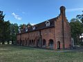
The old Ashburton Library in Ashburton Park, formerly an extension to a mansion
-
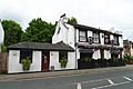
The Joiners Arms pub
-
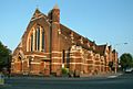
St's Luke's Church, built in 1870 with modifications in 1949, now a grade II listed building
-
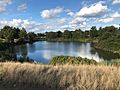
Lake in Brickfields Meadow
-
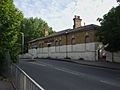
The old Woodside station building, now disused
-
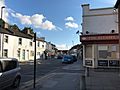
Shops on Woodside Green, with the boarded-up Beehive to the right

.jpg)


