Wrightsville, Pennsylvania facts for kids
Quick facts for kids
Wrightsville, Pennsylvania
Wrights Ferry
|
||
|---|---|---|
|
Borough
|
||
 |
||
|
||

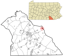
Location in York County and the U.S. state of Pennsylvania.
|
||
| Country | United States | |
| State | Pennsylvania | |
| County | York | |
| Settled | 1811 | |
| Incorporated | 1834 | |
| Government | ||
| • Type | Borough Council | |
| Area | ||
| • Total | 0.66 sq mi (1.70 km2) | |
| • Land | 0.66 sq mi (1.70 km2) | |
| • Water | 0.00 sq mi (0.00 km2) | |
| Elevation | 390 ft (120 m) | |
| Population
(2010)
|
||
| • Total | 2,310 | |
| • Estimate
(2019)
|
2,296 | |
| • Density | 3,505.34/sq mi (1,352.54/km2) | |
| Time zone | UTC-5 (Eastern (EST)) | |
| • Summer (DST) | UTC-4 (EDT) | |
| Zip code |
17368
|
|
| Area code(s) | 717 | |
| FIPS code | 42-86640 | |
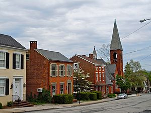
Wrightsville is a borough in York County, Pennsylvania, United States. The population was 2,310 at the 2010 census. Wrightsville borough has a police department, historic society, and a volunteer fire company.
History
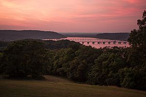
According to a plaque at Samuel S. Lewis State Park, which overlooks Wrightsville and the Susquehanna River, Wrightsville was among George Washington's choices as location of the capital of the United States.
The world's longest covered bridge, at 5,960 feet (1,820 m), once spanned the Susquehanna from Wrightsville to neighboring Columbia in Lancaster County. Built in 1814, it was destroyed by high water and ice in 1832. A replacement bridge was burned the night of June 28, 1863, by state militia during the Gettysburg Campaign in the American Civil War. Confederate troops under John Brown Gordon formed a bucket brigade to save the town from fire. Yet another replacement covered bridge was destroyed by a windstorm a few years later.
The final bridge, the Pennsylvania Railroad Bridge, was a steel open-air bridge constructed in 1896. It was razed in the early 1960s because of obsolescence and restructuring of the railroad industry.
Wrightsville was the northern terminus of the Susquehanna and Tidewater Canal, which extended to Havre de Grace, Maryland.
In 2007, Wrightsville was the chosen location for the rekindling of the War of the Roses between the York Revolution and the Lancaster Barnstormers baseball teams. Wrightsville was chosen for its location on the Susquehanna River, the boundary between York and Lancaster counties.
The Columbia-Wrightsville Bridge and Wrightsville Historic District are listed on the National Register of Historic Places.
Geography
Wrightsville is located at 40°1′28″N 76°31′52″W / 40.02444°N 76.53111°W (40.024481, -76.531221).
According to the United States Census Bureau, the borough has a total area of 0.6 square miles (1.6 km2), all of it land.
Demographics
| Historical population | |||
|---|---|---|---|
| Census | Pop. | %± | |
| 1840 | 672 | — | |
| 1850 | 1,310 | 94.9% | |
| 1860 | 1,360 | 3.8% | |
| 1870 | 1,544 | 13.5% | |
| 1880 | 1,776 | 15.0% | |
| 1890 | 1,912 | 7.7% | |
| 1900 | 2,266 | 18.5% | |
| 1910 | 2,051 | −9.5% | |
| 1920 | 1,943 | −5.3% | |
| 1930 | 2,247 | 15.6% | |
| 1940 | 2,120 | −5.7% | |
| 1950 | 2,104 | −0.8% | |
| 1960 | 2,345 | 11.5% | |
| 1970 | 2,668 | 13.8% | |
| 1980 | 2,365 | −11.4% | |
| 1990 | 2,396 | 1.3% | |
| 2000 | 2,223 | −7.2% | |
| 2010 | 2,310 | 3.9% | |
| 2019 (est.) | 2,296 | −0.6% | |
| Sources: | |||
As of the census of 2000, there were 2,223 people, 955 households, and 606 families residing in the borough. The population density was 3,572.8 people per square mile (1,384.4/km2). There were 1,009 housing units at an average density of 1,621.7 per square mile (628.4/km2). The racial makeup of the borough was 97.62% White, 0.40% African American, 0.09% Native American, 0.36% Asian, 0.54% from other races, and 0.99% from two or more races. Hispanic or Latino of any race were 2.02% of the population.
There were 955 households, out of which 29.7% had children under the age of 18 living with them, 46.1% were married couples living together, 11.1% had a female householder with no husband present, and 36.5% were non-families. 30.6% of all households were made up of individuals, and 11.4% had someone living alone who was 65 years of age or older. The average household size was 2.33 and the average family size was 2.86.
In the borough, the population was spread out, with 23.1% under the age of 18, 7.6% from 18 to 24, 31.4% from 25 to 44, 22.7% from 45 to 64, and 15.2% who were 65 years of age or older. The median age was 38 years. For every 100 females, there were 94.8 males. For every 100 females age 18 and over, there were 92.0 males.
The median income for a household in the borough was $37,379, and the median income for a family was $47,083. Males had a median income of $33,587 versus $23,073 for females. The per capita income for the borough was $18,711. About 4.9% of families and 5.8% of the population were below the poverty line, including 4.8% of those under age 18 and 10.6% of those age 65 or over.
Events
Mud Runs are a popular activity involving mud. Participants run a distance of 3 miles to as long as 10 miles, while crawling through mud bogs, and battling other obstacles. Popular mud runs include Tough Mudder, CerebRun, and Warrior Dash. CerebRun will be held in Wrightsville, Pa.
www.cerebrun.com/events
- Marcello, Ronald E. Small Town America in World War II: War Stories from Wrightsville, Pennsylvania (University of North Texas Press, 2014) 452 pp.
Education
Wrightsville is served by the Eastern York School District.
See also
 In Spanish: Wrightsville (Pensilvania) para niños


